Ticul Municipality
Municipality in the Mexican state of Yucatán
Municipality in Yucatán, Mexico
20°24′N 89°32′W / 20.400°N 89.533°W / 20.400; -89.533 Mexico
 Yucatán
 (2010[3])
97860
Ticul de Morales Municipality is a municipality in the Mexican state of Yucatán. It is located in the western part of the state at (20°24′N 89°32′W / 20.400°N 89.533°W / 20.400; -89.533) 100 km south of the state capital city of Mérida. The municipality, which has an area of 355.12 km² (137.11 sq mi), in the 2005 census reported 25,621 inhabitants. The city of Ticul which is the municipal seat had a population of 21,147, the ninth-largest community in the state in population. The majority are ethnically Maya. Its largest other towns are Pustunich and Yotholín.
Geography
Climate
| Climate data for Ticul | |||||||||||||
|---|---|---|---|---|---|---|---|---|---|---|---|---|---|
| Month | Jan | Feb | Mar | Apr | May | Jun | Jul | Aug | Sep | Oct | Nov | Dec | Year |
| Mean daily maximum °C (°F) | 29.8 (85.6) | 31.7 (89.1) | 34.1 (93.4) | 36.7 (98.1) | 37.7 (99.9) | 35.7 (96.3) | 35.3 (95.5) | 35.1 (95.2) | 34.3 (93.7) | 32.6 (90.7) | 31 (88) | 29.9 (85.8) | 33.7 (92.7) |
| Mean daily minimum °C (°F) | 15 (59) | 15.9 (60.6) | 17.6 (63.7) | 19.4 (66.9) | 21.3 (70.3) | 21.9 (71.4) | 21.2 (70.2) | 21.6 (70.9) | 21.7 (71.1) | 20.6 (69.1) | 18.0 (64.4) | 16.3 (61.3) | 19.2 (66.6) |
| Average precipitation mm (inches) | 20 (0.8) | 130 (5) | 36 (1.4) | 51 (2) | 110 (4.5) | 170 (6.6) | 140 (5.7) | 170 (6.5) | 190 (7.5) | 120 (4.8) | 51 (2) | 41 (1.6) | 1,230 (48.4) |
| Source: Weatherbase[4] | |||||||||||||
Communities
The municipality is made up of 32 communities the most important are as follows:
Notable people
Francisco Ché Cacique de Ticul who ruled from 1562-1569.
Gallery
Wikimedia Commons has media related to Ticul Municipality.
-
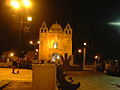 The church at night
 -
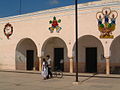 City Hall
 -
 Church


References
- ^ "Presidente Municipal" (in Spanish). Mérida, Mexico: PRI. 2012. Retrieved 6 August 2015.
- ^ a b "Municipios de Yucatán »Santa Elena" (in Spanish). Retrieved 13 November 2018.
- ^ "Mexico In Figures:Sacalum, Yucatán". INEGI (in Spanish and English). Aguascalientes, México: Instituto Nacional de Estadística y Geografía (INEGI). Archived from the original on 6 May 2015. Retrieved 3 August 2015.
- ^ "Weatherbase: Historical Weather for Ticul, Yucatán". Weatherbase. 2011. Retrieved on November 24, 2011.
- v
- t
- e

Mérida (capital)

- Akil
- Baca
- Buctzotz
- Cacalchén
- Cansahcab
- Caucel
- Celestún
- Cenotillo
- Chablecal
- Chelem
- Chichimilá
- Chicxulub
- Chocholá
- Cholul
- Conkal
- Cuzamá
- Dzán
- Dzemul
- Dzidzantún
- Dzilam González
- Halachó
- Hocabá
- Hoctún
- Homún
- Huhí
- Itzincab
- Ixil
- Kantunil
- Kimbilá
- Kinchil
- Komchén
- Maní
- Opichén
- Panabá
- Pisté
- Popolá
- Popolnáh
- Sacalum
- San José Tzal
- Santa Elena
- Seyé
- Sotuta
- Sucilá
- Tahdziú
- Tahmek
- Teabo
- Tecoh
- Tekantó
- Tekit
- Telchac Pueblo
- Temax
- Temozón
- Tetiz
- Timucuy
- Tixcacalcupul
- Tixpéhual
- Tzucacab
- X-Can
| Region 1, Poniente, Yucatán | |
|---|---|
| Region 2: Noroeste, Yucatán | |
| Region 3: Centro, Yucatán | |
| Region 4: Litoral centro, Yucatán | |
| Region 5: Noreste, Yucatán | |
| Region 6: Oriente, Yucatán | |
| Region 7: Sur, Yucatán |
Authority control databases | |
|---|---|
| International |
|
| National |
|


