Olinda
Municipality in Pernambuco, Brazil
Municipality in Northeast, Brazil

Flag

Seal

Location in Pernambuco
 Brazil
 Pernambuco
 (2020 [1])
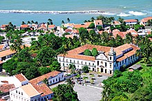
Olinda (Portuguese pronunciation: [ɔˈlĩndɐ]) is a historic city in Pernambuco, Brazil, in the Northeast Region. It is located on the country's northeastern Atlantic Ocean coast, in the Metropolitan Region of Recife, the state capital.[3] It has a population of 393,115 people, covers 41.681 square kilometres (16.093 sq mi), and has a population density of 9,437 inhabitants per square kilometre (24,440/sq mi). It is noted as one of the best-preserved colonial cities in Brazil[4] and has been inhabited since 1535.
As the former capital of the Captaincy of Pernambuco during the colonial era, Olinda has many historical buildings—the center was declared a UNESCO World Heritage Site in 1982—and a rich culture. The Carnaval of Olinda, a popular street party, is very similar to traditional Portuguese carnivals, with the addition of African influenced dances, reflecting the history of the Northeast. All the festivities are celebrated on the streets with no bleachers or roping, and, unlike in other cities, admission is free. There are hundreds of small musical groups (sometimes featuring a single performer) in many genres.
History
| UNESCO World Heritage Site | |
|---|---|
 View of Olinda | |
| Criteria | Cultural: ii, iv |
| Reference | 189 |
| Inscription | 1982 (6th Session) |
| Area | 120 ha |
| Buffer zone | 920 ha |
Several indigenous tribes occupied the coast of Northeastern Brazil for several thousand years, and the hills of the present day municipality of Olinda had settlements of Caetés and Tupinambá tribes, which were frequently at war. French mercenaries are thought to be the first Europeans to reach the region, but the Portuguese exploited intertribal rivalries and managed to build a stronghold on the former Caeté village on a high hill. Recent studies by the Federal University of Pernambuco have uncovered new evidence of the pre-colonial population of the area.
The settlement of Olinda was founded in 1535 by Duarte Coelho Pereira, from Portugal; it was elevated to a town on March 12, 1537.[3] It was made the seat of the Roman Catholic Territorial Prelature of Pernambuco in 1614, becoming the Diocese of Olinda in 1676. The economy of the region was dominated by the production of sugarcane. This, combined with the importing of slaves from Africa to support cultivation made Olinda a colonial stronghold.
Olinda was the capital of the Portuguese hereditary captaincy of Pernambuco, but was burned by Dutch invaders. The Portuguese built their town on the hill, for practical purposes (eg, sewers) and to make it easier to defend. In the 17th century the Kingdom of Portugal was united with Spain (the 1580-1640 Iberian Union). Taking advantage of this period of Portuguese weakness, the area around Olinda and Recife was occupied by the Dutch who gained access to the Portuguese sugarcane plantations.[4] John Maurice, Prince of Nassau-Siegen was appointed as the governor of the Dutch possessions in Brazil in 1637 by the Dutch West India Company on recommendation of Frederick Henry. He landed at Recife, the port of Pernambuco and the chief stronghold of the Dutch, in January 1637. By a series of successful expeditions, he gradually extended the Dutch possessions from Sergipe on the south to São Luís de Maranhão in the north. He likewise conquered the Portuguese possessions of Saint George del Mina, Saint Thomas, and Luanda, Angola, on the west coast of Africa. After the dissolution of the Iberian Union in 1640, Portugal would reestablish its authority over the lost territories of the Portuguese Empire, including the former Dutch Brazil. Sugarcane plantation slavery would continue to be a source of wealth in Olinda until the Lei Áurea ("Golden Law") abolished slavery in an independent Brazil in 1888.
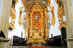
Olinda declined in importance after the Dutch invasion. Recife became the capital of Pernambuco in 1827, and Olinda is part of the greater Recife metropolitan area. Due to the historic position of the city, its cathedral, a World Heritage Site, called São Salvador do Mundo, remains the primary seat of the Roman Catholic Archdiocese of Olinda and Recife,[3] with a co-cathedral in Recife. Olinda also has a Minor Basilica, again a World Heritage Site (Minor): Basílica Abacial do Mosteiro de São Bento de Olinda.[5]
Besides its natural beauty, Olinda is also one of Brazil's main cultural centers: in 1982 it was declared a World Heritage Site by UNESCO. The city relives the magnificence of the past every year during the large Carnival, to the rhythms of frevo, maracatu and other northeast music and dances.
Geography
Olinda is located on the coast of the state of Pernambuco, six kilometers north of the center of Recife. It is bordered by the Atlantic Ocean to the east, the municipality of Paulista to the north, and Recife to the south and west. It is part of the Metropolitan Region of Recife (RMR).
The average elevation is 16 m above sea level. The landscapes is made of plains and hills, some of them steep. Olinda is mostly drained by the Paratibe River (55.13% of the territory), with the remainder drained by the Capibaribe River.[6] The municipality is in the Atlantic Forest ecoregion.
Olinda has a tropical monsoon type climate (Köppen-Geiger: Am), typical of the eastern section of the northeastern Brazilian coast, with average monthly temperatures consistently above 18 °C, little diurnal variation in temperature, abundant rainfall most of the year, and high relative humidity.[7]
Economy


The main economic activities in Olinda are based in tourism, commerce, transportation industry and artcraft. The tourist sector has a boom every Carnival when thousands of people are in the old historic town center.
Economic indicators
| Population | GDP x(1000 R$).[8] | GDP pc (R$) | PE | RMR |
|---|---|---|---|---|
| 397,268 | 2,179,183 | 5,567 | 3.54% | 5.39% |
Economy by Sector
| Primary sector | Secondary sector | Service sector |
|---|---|---|
| 0.17% | 18.70% | 81.13% |
Gallery
Historic Center
-
 One of the roads of the historic center
 -
 A church in the historic center
 -
 Distant view of historic center with sea behind


See also
References
- ^ IBGE 2020
- ^ "Archived copy" (PDF). United Nations Development Programme (UNDP). Archived from the original (PDF) on 8 July 2014. Retrieved 1 August 2013.
{{cite web}}: CS1 maint: archived copy as title (link) - ^ a b c "Olinda". Encyclopædia Britannica. Chicago, Ill.: Encyclopædia Britannica, Inc.
- ^ a b "Pernambuco, Olinda" (in Portuguese). Instituto Brasileiro de Geografia e Estatística. 2016. Retrieved 12 August 2016.
- ^ "Archdiocese of Olinda e Recife, Brazil".
- ^ OLINDA, SECOM-SECRETARIA DE COMUNICAÇÃO DE. "Olinda em Dados". Prefeitura de Olinda, Mais Conquistas para Todos (in Brazilian Portuguese). Retrieved 17 April 2021.
- ^ ""OS MORROS DA REGIÃO METROPOLITANA DO RECIFE"". Agência Estadual de Planejamento e Pesquisas de Pernambuco (CONDEPE/FIDEM). Archived from the original on 2 April 2015. Retrieved 1 May 2014.
- ^ Olinda 2007 GDP IBGE page 31 Archived 2016-03-04 at the Wayback Machine
External links
Wikimedia Commons has media related to Olinda.
![]() Olinda travel guide from Wikivoyage
Olinda travel guide from Wikivoyage
- Official website of the prefeitura
- Official website of the Câmara Municipal
- Explore the Historic Centre of the Town of Olinda in the UNESCO collection on Google Arts and Culture
- https://web.archive.org/web/20130407002251/http://olindavirtual.org/
- https://web.archive.org/web/20060614045202/http://www.olinda.com.br/ Commercial site
- Video Olinda, Pernambuco (PT) [1]
- Video Olinda street Carnival [2]
- v
- t
- e
World Heritage Sites in Brazil


- Brazilian Atlantic Islands
- Fernando de Noronha and Atol das Rocas Reserves
- Discovery Coast Atlantic Forest Reserves1
- Historic Centre of São Luís
- Historic Centre of Salvador de Bahia
- Historic Centre of the Town of Olinda
- São Francisco Square in São Cristóvão
- Serra da Capivara National Park
- Brasília
- Cerrado Protected Areas
- Chapada dos Veadeiros and Emas National Park
- Historic Centre of the Town of Goiás
- Pantanal Conservation Area
- Atlantic Forest South-East Reserves1
- Discovery Coast Atlantic Forest Reserves1
- Historic Centre of the Town of Diamantina
- Historic Town of Ouro Preto
- Pampulha Modern Ensemble, Minas Gerais
- Paraty and Ilha Grande – Culture and Biodiversity
- Rio de Janeiro: Carioca Landscapes between the Mountain and the Sea
- Sanctuary of Bom Jesus de Matosinhos
- Sítio Roberto Burle Marx
- Valongo Wharf Archaeological Site
| ||||||||||||||
|---|---|---|---|---|---|---|---|---|---|---|---|---|---|---|
Capital: Recife | ||||||||||||||
| Mesoregion Agreste Pernambucano |
|  | ||||||||||||
| Mesoregion Mata Pernambucana |
| |||||||||||||
| Mesoregion Metropolitana de Recife |
| |||||||||||||
| Mesoregion Sao Francisco Pernambucano |
| |||||||||||||
| Mesoregion Sertão Pernambucano |
| |||||||||||||
8°00′S 34°53′W / 8.000°S 34.883°W / -8.000; -34.883
Authority control databases | |
|---|---|
| International |
|
| National |
|
| Geographic |
|
| Other |
|


