Bonito, Pernambuco
City in Pernambuco, Brazil
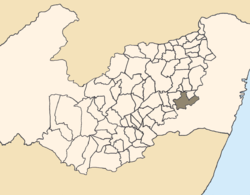
Bonito (Beautiful) (population 38,117)[1] is a city in northeastern Brazil, in the State of Pernambuco. It lies in the mesoregion of Agreste of Pernambuco.Has 399.5 sq/km of total area.

Geography
- State - Pernambuco
- Region - Agreste of Pernambuco
- Boundaries - Camocim de São Félix, Sairé and Barra de Guabiraba (N); Palmares and Catende(S), Cortês and Joaquim Nabuco (E); São Joaquim do Monte and Belém de Maria (W).
- Area - 399.5 km2
- Elevation - 443 m
- Hydrography - Sirinhaém and Una rivers
- Vegetation - Subcaducifolia Forest
- Climate - Hot and Humid
- Annual average temperature - 21 c
- Main road - BR 232 and PE 103
- Distance to Recife - 128 km
Economy
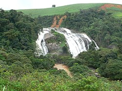
Principal economic activity for Bonito is the agricultural sector. Sugar cane, cattle, tuber production, poultry and fruit. tourism is an emerging field due to the many natural waterfalls accessible by a newly asphalted highway.
Bonito is experiencing a real estate boom driving up the prices of building lots and rental units, proposed improvements to the main route into the city will further drive development.
Economic Indicators
| Population[2] | GDP x(1000 R$).[3] | GDP pc (R$) | PE |
|---|---|---|---|
| 40.832 | 139.985 | 3.579 | 0.24% |
Economy by Sector 2006
| Primary sector | Secondary sector | Service sector |
|---|---|---|
| 21.66% | 10.37% | 67.97% |
Health Indicators
| HDI (2000) | Hospitals (2007) | Hospitals beds (2007) | Children's Mortality every 1000 (2005) |
|---|---|---|---|
| 0.593 | 1 | 52 | 25.5 |
References
External links
- Travel Package to Bonito - Pernambuco
- v
- t
- e

Capital: Recife
Agreste Pernambucano
| Alto Capibaribe | |
|---|---|
| Brejo Pernambucano | |
| Garanhuns | |
| Médio Capibaribe | |
| Vale do Ipanema | |
| Vale do Ipojuca |

Mata Pernambucana
| Mata Meridional Pernambucana | |
|---|---|
| Mata Setentrional Pernambucana | |
| Vitoria de Santo Antão |
Metropolitana de Recife
| Itamaracá | |
|---|---|
| Recife | |
| Porto de Suape | |
| Fernando de Noronha |
Sao Francisco Pernambucano
| Itaparica | |
|---|---|
| Petrolina |
Sertão Pernambucano
| Araripina | |
|---|---|
| Pajeú | |
| Salgueiro | |
| Sertão do Moxotó |
Authority control databases | |
|---|---|
| International |
|
| National |
|
08°28′12″S 35°43′44″W / 8.47000°S 35.72889°W / -8.47000; -35.72889
 | This Pernambuco, Brazil location article is a stub. You can help Wikipedia by expanding it. |
- v
- t
- e


