National Register of Historic Places listings in Sarpy County, Nebraska

This is a list of the National Register of Historic Places listings in Sarpy County, Nebraska.
This is intended to be a complete list of the properties and districts on the National Register of Historic Places in Sarpy County, Nebraska, United States. The locations of National Register properties and districts for which the latitude and longitude coordinates are included below, may be seen in a map.[1]
There are 20 properties and districts listed on the National Register in the county. Another two properties were once listed but have been removed.
This National Park Service list is complete through NPS recent listings posted June 14, 2024.[2]
Map all coordinates using OpenStreetMap
Download coordinates as:
- KML
- GPX (all coordinates)
- GPX (primary coordinates)
- GPX (secondary coordinates)
Current listings
| [3] | Name on the Register | Image | Date listed[4] | Location | City or town | Description |
|---|---|---|---|---|---|---|
| 1 | Bellevue College Dormitories |  | July 24, 2017 (#100001357) | 400 W. 19th Ave. 41°08′28″N 95°53′56″W / 41.141044°N 95.898756°W / 41.141044; -95.898756 (Bellevue College Dormitories) | Bellevue | |
| 2 | Big Papillion Creek Bridge |  | June 29, 1992 (#92000728) | 120th St. over the South Branch of Big Papillion Creek, 3.2 miles west of La Vista 41°10′27″N 96°06′01″W / 41.174167°N 96.100278°W / 41.174167; -96.100278 (Big Papillion Creek Bridge) | La Vista | Bridge replaced in 2000.[5] |
| 3 | Blacksmith Shop | Upload image | May 12, 1978 (#78001711) | South of Bellevue on Offutt Air Force Base 41°07′11″N 95°55′24″W / 41.119722°N 95.923333°W / 41.119722; -95.923333 (Blacksmith Shop) | Bellevue | |
| 4 | Champe-Fremont 1 Archeological Site | Upload image | October 21, 1975 (#75001091) | Address restricted[6] | Gretna | Extends into Douglas County. |
| 5 | Fontenelle Bank | 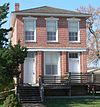 | April 16, 1969 (#69000136) | 2212 Main St. 41°08′12″N 95°53′28″W / 41.13666°N 95.89123°W / 41.13666; -95.89123 (Fontenelle Bank) | Bellevue | |
| 6 | Fontenelle Forest Historic District |  | January 21, 1974 (#74001139) | 1111 Bellevue Blvd N.[7] 41°10′47″N 95°55′04″W / 41.17974°N 95.91776°W / 41.17974; -95.91776 (Fontenelle Forest Historic District) | Bellevue | |
| 7 | Fort Crook Historic District | Upload image | December 12, 1976 (#76001139) | Southwest of Bellevue on Offutt Air Force Base 41°07′23″N 95°55′21″W / 41.123056°N 95.9225°W / 41.123056; -95.9225 (Fort Crook Historic District) | Bellevue | |
| 8 | William E. Gordon House | 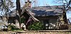 | November 8, 2006 (#06000997) | 711 Bellevue Boulevard, S. 41°09′14″N 95°53′58″W / 41.15375°N 95.89953°W / 41.15375; -95.89953 (William E. Gordon House) | Bellevue | |
| 9 | William Hamilton House |  | October 15, 1969 (#69000137) | 2003 Bluff St. 41°08′21″N 95°53′17″W / 41.13919°N 95.88807°W / 41.13919; -95.88807 (William Hamilton House) | Bellevue | |
| 10 | Kurz Omaha Village | Upload image | August 14, 1973 (#73001073) | Address Restricted | Papillion | |
| 11 | Linoma Beach |  | March 11, 2003 (#03000107) | 17106 S. 255th St. 41°03′44″N 96°19′08″W / 41.062222°N 96.318889°W / 41.062222; -96.318889 (Linoma Beach) | Gretna | |
| 12 | Moses Merrill Mission and Oto Indian Village | Upload image | March 16, 1972 (#72000757) | Address Restricted | La Platte | |
| 13 | Old Log Cabin |  | October 16, 1970 (#70000376) | 1805 Hancock St. 41°08′28″N 95°53′31″W / 41.14123°N 95.89186°W / 41.14123; -95.89186 (Old Log Cabin) | Bellevue | |
| 14 | Patterson Site | Upload image | March 22, 2007 (#07000176) | Address Restricted 41°02′33″N 96°15′15″W / 41.0425°N 96.254167°W / 41.0425; -96.254167 (Patterson Site) | South Bend | |
| 15 | Presbyterian Church |  | October 15, 1970 (#70000377) | 2002 Franklin St. 41°08′22″N 95°53′39″W / 41.13933°N 95.89404°W / 41.13933; -95.89404 (Presbyterian Church) | Bellevue | |
| 16 | Peter A. Sarpy Trading Post Site | Upload image | June 10, 1975 (#75001102) | Address Restricted | Bellevue | |
| 17 | John Sautter Farmhouse |  | September 30, 1980 (#80002463) | 220 N. Jefferson St. 41°09′28″N 96°02′29″W / 41.157778°N 96.041389°W / 41.157778; -96.041389 (John Sautter Farmhouse) | Papillion | |
| 18 | Springfield Community Hall |  | July 23, 1998 (#98000893) | 104 Main St. 41°04′56″N 96°08′04″W / 41.08218°N 96.13437°W / 41.08218; -96.13437 (Springfield Community Hall) | Springfield | |
| 19 | Third Sarpy County Courthouse |  | July 5, 1990 (#90000964) | 3rd St. between Washington and Jefferson Sts. 41°09′31″N 96°02′31″W / 41.158611°N 96.041944°W / 41.158611; -96.041944 (Third Sarpy County Courthouse) | Papillion | |
| 20 | Zweibel Farmstead |  | November 30, 2000 (#00001377) | 16302 S. 63rd St. 41°04′29″N 96°00′42″W / 41.074722°N 96.011667°W / 41.074722; -96.011667 (Zweibel Farmstead) | Papillion |
Former listing
| [3] | Name on the Register | Image | Date listed | Date removed | Location | City or town | Description |
|---|---|---|---|---|---|---|---|
| 1 | Burlington Depot | Upload image | October 16, 1970 (#70000375) | April 13, 1987 | Haworth Park | Bellevue | Relocated to Sarpy County Museum Grounds at Gemini Park |
| 2 | McCarty-Lilley House | Upload image | December 22, 1978 (#78001712) | March 13, 2020 | West of Bellevue on Quail Dr. 41°08′07″N 95°58′20″W / 41.135278°N 95.972222°W / 41.135278; -95.972222 (McCarty-Lilley House) | Bellevue |
See also
Wikimedia Commons has media related to National Register of Historic Places in Sarpy County, Nebraska.
- List of National Historic Landmarks in Nebraska
- National Register of Historic Places listings in Nebraska
References
- ^ The latitude and longitude information provided in this table was derived originally from the National Register Information System, which has been found to be fairly accurate for about 99% of listings. Some locations in this table may have been corrected to current GPS standards.
- ^ National Park Service, United States Department of the Interior, "National Register of Historic Places: Weekly List Actions", retrieved June 14, 2024.
- ^ a b Numbers represent an alphabetical ordering by significant words. Various colorings, defined here, differentiate National Historic Landmarks and historic districts from other NRHP buildings, structures, sites or objects.
- ^ The eight-digit number below each date is the number assigned to each location in the National Register Information System database, which can be viewed by clicking the number.
- ^ http://uglybridges.com/1655316 [dead link]
- ^ Federal and state laws and practices restrict general public access to information regarding the specific location of this resource. In some cases, this is to protect archeological sites from vandalism, while in other cases it is restricted at the request of the owner. See: Knoerl, John; Miller, Diane; Shrimpton, Rebecca H. (1990), Guidelines for Restricting Information about Historic and Prehistoric Resources, National Register Bulletin, National Park Service, U.S. Department of the Interior, OCLC 20706997.
- ^ "Fontenelle Forest". Fontenelle Nature Association website. Retrieved 2012-10-29.
- v
- t
- e

- Adams
- Antelope
- Arthur
- Banner
- Blaine
- Boone
- Box Butte
- Boyd
- Brown
- Buffalo
- Burt
- Butler
- Cass
- Cedar
- Chase
- Cherry
- Cheyenne
- Clay
- Colfax
- Cuming
- Custer
- Dakota
- Dawes
- Dawson
- Deuel
- Dixon
- Dodge
- Douglas
- Dundy
- Fillmore
- Franklin
- Frontier
- Furnas
- Gage
- Garden
- Garfield
- Gosper
- Grant
- Greeley
- Hall
- Hamilton
- Harlan
- Hayes
- Hitchcock
- Holt
- Hooker
- Howard
- Jefferson
- Johnson
- Kearney
- Keith
- Keya Paha
- Kimball
- Knox
- Lancaster
- Lincoln
- Logan
- Loup
- Madison
- McPherson
- Merrick
- Morrill
- Nance
- Nemaha
- Nuckolls
- Otoe
- Pawnee
- Perkins
- Phelps
- Pierce
- Platte
- Polk
- Red Willow
- Richardson
- Rock
- Saline
- Sarpy
- Saunders
- Scotts Bluff
- Seward
- Sheridan
- Sherman
- Sioux
- Stanton
- Thayer
- Thomas
- Thurston
- Valley
- Washington
- Wayne
- Webster
- Wheeler
- York
- Bridges
- Historic districts
- Houses
- National Historic Landmarks
- Properties of religious function
- Railway stations
 Category
 List
List National Register of Historic Places Portal