National Register of Historic Places listings in Butler County, Nebraska

This is a list of the National Register of Historic Places listings in Butler County, Nebraska. It is intended to be a complete list of the properties and districts on the National Register of Historic Places in Butler County, Nebraska, United States. The locations of National Register properties and districts for which the latitude and longitude coordinates are included below, may be seen in a map.[1]
There are 13 properties and districts listed on the National Register in the county.
This National Park Service list is complete through NPS recent listings posted June 14, 2024.[2]
Map all coordinates using OpenStreetMap
Download coordinates as:
- KML
- GPX (all coordinates)
- GPX (primary coordinates)
- GPX (secondary coordinates)
Listings county-wide
| [3] | Name on the Register[4] | Image | Date listed[5] | Location | City or town | Description |
|---|---|---|---|---|---|---|
| 1 | Barcal Site | Upload image | March 24, 1972 (#72000741) | Address Restricted | Abie | |
| 2 | Bellwood Archeological Site | Upload image | August 13, 1974 (#74001102) | Address Restricted | Bellwood | |
| 3 | Big Blue River Bridge |  | June 29, 1992 (#92000708) | Township road over the Big Blue River, 1 mile southeast of Surprise 41°06′03″N 97°17′28″W / 41.100833°N 97.291111°W / 41.100833; -97.291111 (Big Blue River Bridge) | Surprise | |
| 4 | Butler County District No. 10 School |  | December 7, 2011 (#11000884) | 2030 County Road 45 1/2 41°24′07″N 96°59′34″W / 41.40189°N 96.99267°W / 41.40189; -96.99267 (Butler County District No. 10 School) | Linwood vicinity | part of the School Buildings in Nebraska MPS |
| 5 | Clear Creek Bridge |  | June 29, 1992 (#92000734) | Township road over Clear Creek, 5.8 miles northwest of Bellwood 41°23′03″N 97°20′06″W / 41.384167°N 97.335°W / 41.384167; -97.335 (Clear Creek Bridge) | Bellwood | |
| 6 | David City Park and Municipal Auditorium | 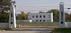 | November 15, 2000 (#00001378) | Southern side of town, bordering Nebraska Highway 15 41°14′45″N 97°07′26″W / 41.245833°N 97.123889°W / 41.245833; -97.123889 (David City Park and Municipal Auditorium) | David City | |
| 7 | Fremont, Elkhorn and Missouri Valley Railroad Depot | 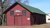 | October 11, 1979 (#79003682) | 1st and Maple Sts. 41°04′58″N 97°01′06″W / 41.082778°N 97.018333°W / 41.082778; -97.018333 (Fremont, Elkhorn and Missouri Valley Railroad Depot) | Dwight | |
| 8 | Linwood Site | Upload image | March 16, 1972 (#72000742) | Address Restricted | Linwood | |
| 9 | St. Mary of the Assumption Catholic Church, School and Grottoes |  | December 4, 2008 (#08001132) | 336 W. Pine St. 41°05′02″N 97°01′22″W / 41.08388°N 97.02273°W / 41.08388; -97.02273 (St. Mary of the Assumption Catholic Church, School and Grottoes) | Dwight | |
| 10 | Surprise Opera House | 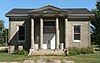 | July 6, 1988 (#88000940) | Southeastern corner of the intersection of Miller and River Sts. 41°06′10″N 97°18′38″W / 41.102778°N 97.310556°W / 41.102778; -97.310556 (Surprise Opera House) | Surprise | |
| 11 | Chauncey S. Taylor House | 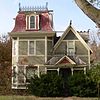 | June 25, 1982 (#82003184) | 715 4th St. 41°15′23″N 97°08′32″W / 41.256389°N 97.142222°W / 41.256389; -97.142222 (Chauncey S. Taylor House) | David City | |
| 12 | Thorpe's Opera House |  | September 28, 1988 (#88000941) | 457½ D St. 41°15′09″N 97°07′44″W / 41.2525°N 97.128889°W / 41.2525; -97.128889 (Thorpe's Opera House) | David City | |
| 13 | Upper Oak Creek Descent Ruts of the Woodbury Cutoff, Ox Bow Trail of the California Road |  | November 27, 1992 (#92001572) | Roughly 4 miles southeast of Brainard 41°07′35″N 96°58′26″W / 41.12636°N 96.97378°W / 41.12636; -96.97378 (Upper Oak Creek Descent Ruts of the Woodbury Cutoff, Ox Bow Trail of the California Road) | Brainard |
See also
- List of National Historic Landmarks in Nebraska
- National Register of Historic Places listings in Nebraska
References
- ^ The latitude and longitude information provided in this table was derived originally from the National Register Information System, which has been found to be fairly accurate for about 99% of listings. Some locations in this table may have been corrected to current GPS standards.
- ^ National Park Service, United States Department of the Interior, "National Register of Historic Places: Weekly List Actions", retrieved June 14, 2024.
- ^ Numbers represent an alphabetical ordering by significant words. Various colorings, defined here, differentiate National Historic Landmarks and historic districts from other NRHP buildings, structures, sites or objects.
- ^ "National Register Information System". National Register of Historic Places. National Park Service. April 24, 2008.
- ^ The eight-digit number below each date is the number assigned to each location in the National Register Information System database, which can be viewed by clicking the number.
External links
Wikimedia Commons has media related to National Register of Historic Places in Butler County, Nebraska.
- Nebraska National Register Sites in Butler County[usurped]–Nebraska State Historical Society
- v
- t
- e

- Adams
- Antelope
- Arthur
- Banner
- Blaine
- Boone
- Box Butte
- Boyd
- Brown
- Buffalo
- Burt
- Butler
- Cass
- Cedar
- Chase
- Cherry
- Cheyenne
- Clay
- Colfax
- Cuming
- Custer
- Dakota
- Dawes
- Dawson
- Deuel
- Dixon
- Dodge
- Douglas
- Dundy
- Fillmore
- Franklin
- Frontier
- Furnas
- Gage
- Garden
- Garfield
- Gosper
- Grant
- Greeley
- Hall
- Hamilton
- Harlan
- Hayes
- Hitchcock
- Holt
- Hooker
- Howard
- Jefferson
- Johnson
- Kearney
- Keith
- Keya Paha
- Kimball
- Knox
- Lancaster
- Lincoln
- Logan
- Loup
- Madison
- McPherson
- Merrick
- Morrill
- Nance
- Nemaha
- Nuckolls
- Otoe
- Pawnee
- Perkins
- Phelps
- Pierce
- Platte
- Polk
- Red Willow
- Richardson
- Rock
- Saline
- Sarpy
- Saunders
- Scotts Bluff
- Seward
- Sheridan
- Sherman
- Sioux
- Stanton
- Thayer
- Thomas
- Thurston
- Valley
- Washington
- Wayne
- Webster
- Wheeler
- York
- Bridges
- Historic districts
- Houses
- National Historic Landmarks
- Properties of religious function
- Railway stations
 Category
 List
List National Register of Historic Places Portal


Municipalities and communities of Butler County, Nebraska, United States | ||
|---|---|---|
County seat: David City | ||
| City |  | |
| Villages | ||
| Townships | ||
| Unincorporated communities | ||
| Ghost town | ||
| ||


