Dachau (district)
District in Bavaria, Germany
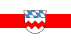
Flag
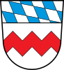
Coat of arms

(31 December 2022)[1]
Dachau (German pronunciation: [ˈdaxaʊ]) is a Landkreis (district) in Bavaria, Germany. It is bounded by (from the south and clockwise) the districts of Fürstenfeldbruck, Aichach-Friedberg, Pfaffenhofen, Freising and Munich, and by the city of Munich.
History
The district was established in 1952. There were slight changes to the territory in the administrative reform of 1972.
Geography

The district extends from the northwestern suburbs of Munich to the so-called Dachauer Land. It is a hilly countryside, which is now densely populated. The growing Munich metropolitan area is advancing more and more into the district's territory.
Coat of arms
The arms include a red zigzag line on white background, which was the heraldic figure of the Wittelsbach family during the 12th and 13th century. Although it was not used anymore from the 14th century on, it is now part of the arms of Dachau in order to symbolise, that Dachau is an old part of the Bavarian state. In the upper part of the arms the blue and white checkered pattern of Bavaria is displayed.
Towns and municipalities

| Towns | Municipalities | |
|---|---|---|
|
References
- ^ Genesis Online-Datenbank des Bayerischen Landesamtes für Statistik Tabelle 12411-003r Fortschreibung des Bevölkerungsstandes: Gemeinden, Stichtag (Einwohnerzahlen auf Grundlage des Zensus 2011) (Hilfe dazu).
External links
Wikimedia Commons has media related to Landkreis Dachau.
- Official website (German)
- v
- t
- e
Urban and rural districts in the Free State of Bavaria in Germany
districts
- Amberg
- Ansbach
- Aschaffenburg
- Augsburg
- Bamberg
- Bayreuth
- Coburg
- Erlangen
- Fürth
- Hof
- Ingolstadt
- Kaufbeuren
- Kempten
- Landshut
- Memmingen
- München (Munich)
- Nürnberg (Nuremberg)
- Passau
- Regensburg
- Rosenheim
- Schwabach
- Schweinfurt
- Straubing
- Weiden
- Würzburg
districts
- Aichach-Friedberg
- Altötting
- Amberg-Sulzbach
- Ansbach
- Aschaffenburg
- Augsburg
- Bad Kissingen
- Bad Tölz-Wolfratshausen
- Bamberg
- Bayreuth
- Berchtesgadener Land
- Cham
- Coburg
- Dachau
- Deggendorf
- Dillingen
- Dingolfing-Landau
- Donau-Ries
- Ebersberg
- Eichstätt
- Erding
- Erlangen-Höchstadt
- Forchheim
- Freising
- Freyung-Grafenau
- Fürstenfeldbruck
- Fürth
- Garmisch-Partenkirchen
- Günzburg
- Haßberge
- Hof
- Kelheim
- Kitzingen
- Kronach
- Kulmbach
- Landsberg
- Landshut
- Lichtenfels
- Lindau
- Main-Spessart
- Miesbach
- Miltenberg
- Mühldorf
- München (Munich)
- Neuburg-Schrobenhausen
- Neumarkt
- Neustadt (Aisch)-Bad Windsheim
- Neustadt an der Waldnaab
- Neu-Ulm
- Nürnberger Land
- Oberallgäu
- Ostallgäu
- Passau
- Pfaffenhofen
- Regen
- Regensburg
- Rhön-Grabfeld
- Rosenheim
- Roth
- Rottal-Inn
- Schwandorf
- Schweinfurt
- Starnberg
- Straubing-Bogen
- Tirschenreuth
- Traunstein
- Unterallgäu
- Weilheim-Schongau
- Weißenburg-Gunzenhausen
- Wunsiedel
- Würzburg
Towns and municipalities in Dachau (district) | ||
|---|---|---|
 | ||
48°15′N 11°25′E / 48.25°N 11.42°E / 48.25; 11.42
Authority control databases | |
|---|---|
| International |
|
| National |
|


