Neuburg-Schrobenhausen
District in Bavaria, Germany
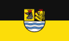
Flag
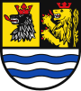
Coat of arms

(31 December 2022)[1]
Neuburg-Schrobenhausen is a Landkreis (district) in Bavaria, Germany. It is bounded by (from the east and clockwise) the districts of Pfaffenhofen, Aichach-Friedberg, Donau-Ries and Eichstätt, and by the city of Ingolstadt.
History
The district was established in 1972 by merging the former districts of Neuburg and Schrobenhausen.
Geography

The district consists of the previously swampy areas between the Danube and Paar rivers, that are called the Donaumoos. North of the Danube the district includes a small part of the Altmühl Valley Nature Park.
Coat of arms
The coat of arms displays:
- the bear's head from the city arms of Schrobenhausen
- the heraldic lion of the Electorate of the Palatinate
- a wavy line symbolising the Danube River
Towns and municipalities

| Towns | Municipalities | |
|---|---|---|
References
- ^ Genesis Online-Datenbank des Bayerischen Landesamtes für Statistik Tabelle 12411-003r Fortschreibung des Bevölkerungsstandes: Gemeinden, Stichtag (Einwohnerzahlen auf Grundlage des Zensus 2011) (Hilfe dazu).
External links
Wikimedia Commons has media related to Landkreis Neuburg-Schrobenhausen.
- Official website (German)
- v
- t
- e
Urban and rural districts in the Free State of Bavaria in Germany
districts
- Amberg
- Ansbach
- Aschaffenburg
- Augsburg
- Bamberg
- Bayreuth
- Coburg
- Erlangen
- Fürth
- Hof
- Ingolstadt
- Kaufbeuren
- Kempten
- Landshut
- Memmingen
- München (Munich)
- Nürnberg (Nuremberg)
- Passau
- Regensburg
- Rosenheim
- Schwabach
- Schweinfurt
- Straubing
- Weiden
- Würzburg
districts
- Aichach-Friedberg
- Altötting
- Amberg-Sulzbach
- Ansbach
- Aschaffenburg
- Augsburg
- Bad Kissingen
- Bad Tölz-Wolfratshausen
- Bamberg
- Bayreuth
- Berchtesgadener Land
- Cham
- Coburg
- Dachau
- Deggendorf
- Dillingen
- Dingolfing-Landau
- Donau-Ries
- Ebersberg
- Eichstätt
- Erding
- Erlangen-Höchstadt
- Forchheim
- Freising
- Freyung-Grafenau
- Fürstenfeldbruck
- Fürth
- Garmisch-Partenkirchen
- Günzburg
- Haßberge
- Hof
- Kelheim
- Kitzingen
- Kronach
- Kulmbach
- Landsberg
- Landshut
- Lichtenfels
- Lindau
- Main-Spessart
- Miesbach
- Miltenberg
- Mühldorf
- München (Munich)
- Neuburg-Schrobenhausen
- Neumarkt
- Neustadt (Aisch)-Bad Windsheim
- Neustadt an der Waldnaab
- Neu-Ulm
- Nürnberger Land
- Oberallgäu
- Ostallgäu
- Passau
- Pfaffenhofen
- Regen
- Regensburg
- Rhön-Grabfeld
- Rosenheim
- Roth
- Rottal-Inn
- Schwandorf
- Schweinfurt
- Starnberg
- Straubing-Bogen
- Tirschenreuth
- Traunstein
- Unterallgäu
- Weilheim-Schongau
- Weißenburg-Gunzenhausen
- Wunsiedel
- Würzburg
Towns and municipalities in Neuburg-Schrobenhausen | ||
|---|---|---|
 | ||
48°40′N 11°10′E / 48.67°N 11.17°E / 48.67; 11.17
Authority control databases | |
|---|---|
| International |
|
| National |
|


