Liste der Einträge im National Register of Historic Places im Adams County (Illinois)

Die Liste der Einträge im National Register of Historic Places im Adams County in Illinois führt die Bauwerke und historischen Stätten im Adams County auf, die in das National Register of Historic Places aufgenommen wurden.[1]
Legende
| NRHP | Historic Place |
|---|---|
| HD | Historic District |
Aktuelle Einträge
| [2] | Name[3] | Bild | Eintragsdatum | Lage | Ort | Beschreibung |
|---|---|---|---|---|---|---|
| 1 | Coca-Cola Bottling Company Building |  | 1997 ID-Nr. 97000032 | 616 North 24th Street 39° 56′ 18″ N, 91° 22′ 37″ W39.938333-91.376944 | Quincy | |
| 2 | Downtown Quincy Historic District |  | 1983 ID-Nr. 83000298 | Abgegrenzt durch Hampshire Street, Jersey Street, 4th Street und 8th Street 39° 55′ 57″ N, 91° 24′ 28″ W39.9325-91.407778 | Quincy | |
| 3 | Ebenezer Methodist Episcopal Chapel and Cemetery | 1984 ID-Nr. 84000921 | Nordwestlich von Golden 40° 9′ 32″ N, 91° 6′ 10″ W40.158889-91.102778 | Golden | ||
| 4 | Exchange Bank | 1987 ID-Nr. 86003714 | Quincy Street 40° 6′ 26″ N, 91° 1′ 1″ W40.107222-91.016944 | Golden | ||
| 5 | Fall Creek Stone Arch Bridge |  | 1996 ID-Nr. 96001282 | Brücke der Payson Road über den Fall Creek 39° 47′ 6″ N, 91° 18′ 8″ W39.785-91.302222 | Payson | |
| 6 | Robert W. Gardner House |  | 1979 ID-Nr. 79000812 | 613 Broadway 39° 56′ 9″ N, 91° 24′ 21″ W39.935833-91.405833 | Quincy | |
| 7 | S.J. Lesem Building |  | 1999 ID-Nr. 99001377 | 135-37 North 3rd Street 39° 56′ 6″ N, 91° 24′ 43″ W39.935-91.411944 | Quincy | |
| 8 | Lewis Round Barn |  | 2003 ID-Nr. 02001750 | 2007 East 1250th Street 40° 3′ 6″ N, 91° 16′ 19″ W40.051667-91.271944 | Mendon | Ursprünglich 1984 in das Register eingetragen (Ref.-Nr. 84000916); 2002 aus dem Register gestrichen; 2003 nach erfolgter Umsetzung erneut eingetragen |
| 9 | Lock and Dam No. 21 Historic District |  | 2004 ID-Nr. 04000181 | Rund 800 m westlich der IL 57 39° 54′ 22″ N, 91° 25′ 55,9″ W39.906103-91.432186 | Quincy | |
| 10 | Morgan-Wells House |  | 1977 ID-Nr. 77000471 | 421 Jersey Street 39° 55′ 52″ N, 91° 24′ 32″ W39.931111-91.408889 | Quincy | |
| 11 | Richard F. Newcomb House |  | 1982 ID-Nr. 82002516 | 1601 Maine Street 39° 55′ 56″ N, 91° 23′ 24″ W39.932222-91.39 | Quincy | |
| 12 | One Thirty North Eighth Building |  | 1984 ID-Nr. 84000918 | 130 North 8th Street 39° 55′ 58″ N, 91° 24′ 10″ W39.932778-91.402778 | Quincy | |
| 13 | Quincy East End Historic District | 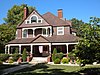 | 1985 ID-Nr. 85002791 | Abgegrenzt durch Hampshire Street, 24th Street, State Street und 12th Street 39° 55′ 51″ N, 91° 23′ 11″ W39.930833-91.386389 | Quincy | |
| 14 | Quincy National Cemetery |  | 2011 ID-Nr. 11000242 | 36th Street Ecke Main Street 39° 55′ 58″ N, 91° 21′ 25″ W39.932778-91.356944 | Quincy | Teil der MPS Civil War Era National Cemeteries |
| 15 | Quincy Northwest Historic District |  | 2000 ID-Nr. 00000414 | Abgegrenzt durch Broadway, North 2nd Street, Locust Street und North 12th Street 39° 56′ 43″ N, 91° 24′ 18″ W39.945278-91.405 | Quincy | |
| 16 | John Roy Site | 1978 ID-Nr. 78001109 | Südwestlich der Kreuzung von 1700th Avenue und 2950th Street 39° 59′ 56″ N, 90° 56′ 59″ W39.99888-90.94972 | Clayton | ||
| 17 | South Side German Historic District |  | 1992 ID-Nr. 92000484 | Abgegrenzt durch 6th Street, 12th Street, Washington Street, Jersey Street und York Street; erweitert um Jefferson Street, South 12th Street, Jackson Street und South 5th Street 39° 55′ 33″ N, 91° 24′ 7″ W39.925833-91.401944 | Quincy | Erweiterung im Jahr 1995 (Ref.-Nr. 95000481) |
| 18 | State Savings Loan and Trust | 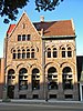 | 1979 ID-Nr. 79000813 | 428 Maine Street 39° 55′ 55″ N, 91° 24′ 32″ W39.931944-91.408889 | Quincy | |
| 19 | F. D. Thomas House | 1983 ID-Nr. 83000299 | 321 North Ohio Street 40° 2′ 50″ N, 91° 3′ 50″ W40.047222-91.063889 | Camp Point | ||
| 20 | U.S. Post Office and Courthouse |  | 1977 ID-Nr. 77000472 | 200 North 8th Street 39° 56′ 1″ N, 91° 24′ 10″ W39.933611-91.402778 | Quincy | |
| 21 | Ursa Town Hall | 2002 ID-Nr. 02000095 | 109 South Warsaw Street 40° 4′ 32″ N, 91° 21′ 59″ W40.075556-91.366389 | Ursa | ||
| 22 | Villa de Kathrine |  | 1978 ID-Nr. 78001110 | 532 South 3rd Street 39° 55′ 33″ N, 91° 24′ 46″ W39.925833-91.412778 | Quincy | |
| 23 | William S. Warfield House |  | 1979 ID-Nr. 79000814 | 1624 Maine Street 39° 55′ 53″ N, 91° 23′ 23″ W39.931389-91.389722 | Quincy | |
| 24 | Ernest M. Wood Office and Studio |  | 1982 ID-Nr. 82002517 | 126 North 8th Street 39° 55′ 57″ N, 91° 24′ 10″ W39.9325-91.402778 | Quincy | |
| 25 | John Wood Mansion |  | 1970 ID-Nr. 70000228 | 425 South 12th Street 39° 55′ 39″ N, 91° 23′ 45″ W39.9275-91.395833 | Quincy | |
| 26 | Woodland Cemetery |  | 2002 ID-Nr. 02000096 | 1020 South Fifth Street 39° 55′ 1″ N, 91° 12′ 55″ W39.916944-91.215278 | Quincy |
Siehe auch
Einzelnachweise
- ↑ Auszug aus dem National Register of Historic Places - Adams County Abgerufen am 15. November 2012
- ↑ Die Nummerierung in dieser Listenspalte ist an der vom National Park Service vorgelegten Reihenfolge der Einträge orientiert; die Farben unterscheiden verschiedene Schutzgebietstypen des Nationalparksystems mit landesweiter Bedeutung (z. B. National Historic Landmarks) von den sonstigen Einträgen im National Register of Historic Places.
- ↑ National Register Information System. In: National Register of Historic Places. National Park Service, abgerufen am 9. Juli 2010 (englisch).

Einträge im National Register of Historic Places in Illinois
National Register of Historic Places in Illinois
Adams | Alexander | Bond | Boone | Brown | Bureau | Calhoun | Carroll | Cass | Champaign | Christian | Clark | Clay | Clinton | Coles | Cook (inkl. Chicago) | Crawford | Cumberland | DeKalb | DeWitt | Douglas | DuPage | Edgar | Edwards | Effingham | Fayette | Ford | Franklin | Fulton | Gallatin | Greene | Grundy | Hamilton | Hancock | Hardin | Henderson | Henry | Iroquois | Jackson | Jasper | Jefferson | Jersey | Jo Daviess | Johnson | Kane | Kankakee | Kendall | Knox | LaSalle | Lake | Lawrence | Lee | Livingston | Logan | Macon | Macoupin | Madison | Marion | Marshall | Mason | Massac | McDonough | McHenry | McLean | Menard | Mercer | Monroe | Montgomery | Morgan | Moultrie | Ogle | Peoria | Perry | Piatt | Pike | Pope | Pulaski | Putnam | Randolph | Richland | Rock Island | Saline | Sangamon | Schuyler | Scott | Shelby | St. Clair | Stark | Stephenson | Tazewell | Union | Vermilion | Wabash | Warren | Washington | Wayne | White | Whiteside | Will | Williamson | Winnebago | Woodford


