Liste der Einträge im National Register of Historic Places im Jo Daviess County

Die Liste der Einträge im National Register of Historic Places im Jo Daviess County in Illinois führt alle 17 Bauwerke und historischen Stätten im Jo Daviess County auf, die in das National Register of Historic Places aufgenommen wurden.[1]
Legende
| NRHP | Historic Place |
|---|---|
| HD | Historic District |
| NHL | National Historic Landmark |
Aktuelle Einträge
| Lfd. Nr. | Name im NRHP | Bild | Jahr der Eintragung | Adresse / Lage | Ort | NRHP-ID |
|---|---|---|---|---|---|---|
| 1 | Apple River Fort |  | 1997 | 400 East Myrtle Street 42° 19′ 5″ N, 90° 12′ 51″ W42.318055555556-90.214166666667 | Elizabeth | 97001332 |
| 2 | John Chapman Village Site |  | 2009 | Hanover | 09001058 | |
| 3 | Chicago Great Western Railroad Depot |  | 1996 | Myrtle Street zwischen North Madison und Vine Street 42° 19′ 1″ N, 90° 13′ 21″ W42.316944444444-90.2225 | Elizabeth | 96000098 |
| 4 | East Dubuque School | 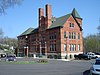 | 1982 | Montgomery Avenue 42° 29′ 38″ N, 90° 38′ 29″ W42.493888888889-90.641388888889 | East Dubuque | 82000396 |
| 5 | Henry N. Frentess Farmstead |  | 2011 | 19140 U.S. Highway 20 West 42° 28′ 20″ N, 90° 36′ 30″ W42.472222222222-90.608333333333 | East Dubuque | |
| 6 | Galena Historic District | 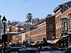 | 1969 | Galena und Umgebung 42° 25′ 6″ N, 90° 25′ 40″ W42.418333333333-90.427777777778 | Galena | 69000056 |
| 7 | Ulysses S. Grant Home |  | 1966 | 511 Bouthillier Street 42° 24′ 40″ N, 90° 25′ 27″ W42.411111111111-90.424166666667 | Galena | 66000322 |
| 8 | Henry W. Miller House |  | 2010 | 11672 West Norris Lane 42° 26′ 48″ N, 90° 27′ 36″ W42.446666666667-90.46 | Galena | |
| 9 | Millville Town Site |  | 2003 | Apple River Canyon State Park, 8663 East Canyon Road 42° 26′ 36″ N, 90° 3′ 7″ W42.443333333333-90.051944444444 | Apple River | 03000066 |
| 10 | Old Market House |  | 1973 | Market Square Ecke Commerce Street 42° 24′ 56″ N, 90° 25′ 38″ W42.415555555556-90.427222222222 | Galena | 73000707 |
| 11 | Old Stone Hotel | 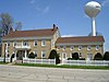 | 1975 | 110 West Main Street 42° 29′ 50″ N, 89° 59′ 28″ W42.497222222222-89.991111111111 | Warren | 75000665 |
| 12 | Scales Mound Historic District |  | 1990 | Abgegrenzt durch die Ortsgrenze von Scales Mound 42° 28′ 55″ N, 90° 15′ 10″ W42.481944444444-90.252777777778 | Scales Mound | 90001199 |
| 13 | Townsend Home | 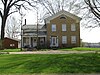 | 2005 | 117 North Canyon Park Road 42° 22′ 26″ N, 90° 3′ 3″ W42.373888888889-90.050833333333 | Stockton | 05000111 |
| 14 | Warren Commercial Historic District |  | 1995 | 102–165 East Main Street, 204–210 East Bunett Street, 102–108 South Railroad Street 42° 29′ 45″ N, 89° 59′ 15″ W42.495833333333-89.9875 | Warren | 95001241 |
| 15 | Elihu Benjamin Washburne House |  | 1973 | 908 3rd Street 42° 24′ 50″ N, 90° 25′ 54″ W42.413888888889-90.431666666667 | Galena | 73000708 |
| 16 | Charles Wenner House |  | 1984 | Rocky Road 42° 27′ 40″ N, 90° 24′ 39″ W42.461111111111-90.410833333333 | Galena | 84001073 |
| 17 | W.E. White Building |  | 1997 | 100 North Main Street 42° 21′ 0″ N, 90° 0′ 24″ W42.35-90.006666666667 | Stockton | 97001339 |
Siehe auch
Einzelnachweise
- ↑ Auszug aus dem National Register of Historic Places - Jo Daviess County Abgerufen am 12. Juli 2012

Einträge im National Register of Historic Places in Illinois
National Register of Historic Places in Illinois
Adams | Alexander | Bond | Boone | Brown | Bureau | Calhoun | Carroll | Cass | Champaign | Christian | Clark | Clay | Clinton | Coles | Cook (inkl. Chicago) | Crawford | Cumberland | DeKalb | DeWitt | Douglas | DuPage | Edgar | Edwards | Effingham | Fayette | Ford | Franklin | Fulton | Gallatin | Greene | Grundy | Hamilton | Hancock | Hardin | Henderson | Henry | Iroquois | Jackson | Jasper | Jefferson | Jersey | Jo Daviess | Johnson | Kane | Kankakee | Kendall | Knox | LaSalle | Lake | Lawrence | Lee | Livingston | Logan | Macon | Macoupin | Madison | Marion | Marshall | Mason | Massac | McDonough | McHenry | McLean | Menard | Mercer | Monroe | Montgomery | Morgan | Moultrie | Ogle | Peoria | Perry | Piatt | Pike | Pope | Pulaski | Putnam | Randolph | Richland | Rock Island | Saline | Sangamon | Schuyler | Scott | Shelby | St. Clair | Stark | Stephenson | Tazewell | Union | Vermilion | Wabash | Warren | Washington | Wayne | White | Whiteside | Will | Williamson | Winnebago | Woodford


