Hrabstwo Tuolumne
| hrabstwo | |||
 | |||
| |||
| Państwo |
| ||
|---|---|---|---|
| Stan |
| ||
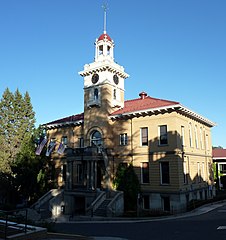
| Siedziba | Sonora | ||
| Kod statystyczny | FIPS 6-4: 06109 | ||
| Powierzchnia | 5890,51 km²[1] | ||
| Populacja (2009) • liczba ludności |
| ||
Położenie na mapie Kalifornia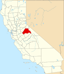 | |||
| 38°01′12″N 119°56′24″W/38,020000 -119,940000 | |||
| |||
| Strona internetowa | |||


Hrabstwo Tuolumne (ang. Tuolumne County) – hrabstwo w stanie Kalifornia w Stanach Zjednoczonych. Obszar całkowity hrabstwa obejmuje powierzchnię 2274,34 mil² (5890,51 km²). Według szacunków United States Census Bureau w roku 2009 miało 55 175 mieszkańców[2].
Hrabstwo powstało w 1850 roku[3].
Na jego terenie znajduje się[4]
- miejscowość - Sonora
- CDP - Cedar Ridge, Chinese Camp, Cold Springs, Columbia, East Sonora, Groveland, Jamestown, Long Barn, Mi-Wuk Village, Mono Vista, Phoenix Lake, Pine Mountain Lake, Sierra Village, Soulsbyville, Strawberry, Tuolumne City, Tuttletown, Twain Harte.
Przypisy
- ↑ US Census Bureau: Population, Housing Units, Area, and Density: 2000. [dostęp 2012-11-13]. [zarchiwizowane z tego adresu (2015-07-08)]. (ang.).
- ↑ a b US Census Bureau: Tuolumne County. Quickfacts. [dostęp 2011-02-01]. (ang.).
- ↑ National Association of Counties: Tuolumne County, CA. [dostęp 2011-02-01]. (ang.).
- ↑ National Association of Counties: Places in Tuolumne County, CA. [dostęp 2011-02-01]. (ang.).
- p
- d
- e
Hrabstwo Tuolumne (Tuolumne County)
- Siedziba hrabstwa: Sonora
| Miasta |
|
|---|---|
| CDP |
|
| Obszary niemunicypalne |
|

- p
- d
- e
|

- Wikiprojekt:Kalifornia


