Tilloy-lès-Mofflaines
Gemeente in Frankrijk  | |||
|---|---|---|---|
 | |||
  | |||
| Situering | |||
| Regio | Hauts-de-France | ||
| Departement | Pas-de-Calais (62) | ||
| Arrondissement | Arras | ||
| Kanton | Arras-3 | ||
| Coördinaten | 50° 16′ NB, 2° 49′ OL | ||
| Algemeen | |||
| Oppervlakte | 7,69 km² | ||
| Inwoners (1 januari 2021) | 1.519[1] (198 inw./km²) | ||
| Hoogte | 45 - 102 m | ||
| Overig | |||
| Postcode | 62217 | ||
| INSEE-code | 62817 | ||
| Foto's | |||
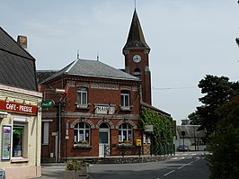 | |||
| Gemeentehuis | |||
| |||

Tilloy-lès-Mofflaines is een gemeente in het Franse departement Pas-de-Calais (regio Hauts-de-France). De plaats maakt deel uit van het arrondissement Arras. Tilloy-lès-Mofflaines telde op 1 januari 2021 1.519[1] inwoners.
Geografie
De oppervlakte van Tilloy-lès-Mofflaines bedroeg op 1 januari 2021 7,69 vierkante kilometer; de bevolkingsdichtheid was toen 197,5 inwoners per km².

Demografie
Onderstaande figuur toont het verloop van het inwonertal (bron: INSEE-tellingen).

Britse militaire begraafplaatsen
Op het grondgebied van de gemeente bevinden zich vier Britse militaire begraafplaatsen met gesneuvelden uit de Eerste Wereldoorlog: Tilloy British Cemetery, Bunyans Cemetery, Gourock Trench Cemetery en Houdain Lane Cemetery.
Externe links
- (fr) Statistische informatie op de website van INSEE
Bronnen, noten en/of referenties
- ↑ a b Populations légales 2021.
Mediabestanden
Zie de categorie Tilloy-lès-Mofflaines van Wikimedia Commons voor mediabestanden over dit onderwerp.


