Pucallpa
 Zie Pucallpa (geslacht) voor het geslacht van boktorren.
Stad (ciudad) in Peru  | |||
|---|---|---|---|
  | |||
  | |||
| Situering | |||
| Provincie | Coronel Portillo | ||
| Regio | Ucayali | ||
| Coördinaten | 8° 23′ ZB, 74° 32′ WL | ||
| Algemene informatie | |||
| Inwoners (2015) | 211.651[1] | ||
| Hoogte | 120 m | ||
| Politiek | |||
| Burgemeester | Segundo Leónidas Pérez Collazos (2019-2022) | ||
| Overig | |||
| Website | mcp.gob.pe | ||
| |||

Pucallpa (Quechua: puka hallpa, "rode aarde") is een stad in de provincie Coronel Portillo, en de regio Ucayali van Peru. Het is strategisch gelegen aan de rivier de Ucayali en fungeert als belangrijkste doorvoerhaven naar het stroomafwaarts gelegen Amazonebekken en de stad Iquitos in de regio Loreto.
Bestuurlijke indeling
Deze stad (ciudad[2]) bestaat uit twee districten:
- Callería (hoofdplaats van de provincie)
- Yarinacocha
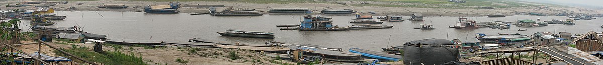
Pucallpillo, de haven van Pucallpa
| Bronnen, noten en/of referenties |

Steden in Peru met meer dan 100.000 inwoners
Arequipa · Ayacucho · Cajamarca · Chiclayo · Chimbote · Chincha Alta · Cuzco · Huancayo · Huánuco · Huaraz · Ica · Iquitos · Juliaca · Lima · Pisco · Piura · Pucallpa · Puno · Sullana · Tacna · Tarapoto · Trujillo · Tumbes


