Orangeburg County
County in de Verenigde Staten  | |||
|---|---|---|---|
 | |||
| Situering | |||
| Staat | South Carolina | ||
| Coördinaten | 33°26'24"NB, 80°48'0"WL | ||
| Algemeen | |||
| Oppervlakte | 2.922 km² | ||
| - land | 2.865 km² | ||
| - water | 57 km² | ||
| Inwoners (2000) | 91.582 (32 inw./km²) | ||
| Overig | |||
| Zetel | Orangeburg | ||
| FIPS-code | 45075 | ||
| Opgericht | 1769 | ||
| Foto's | |||
 Bevolkingspiramide Orangeburg County | |||
| Statistieken volkstelling Orangeburg County | |||
| |||

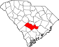
Orangeburg County is een van de 46 county's in de Amerikaanse staat South Carolina. Het wordt gerekend tot de Midlands van deze staat.
De county heeft een landoppervlakte van 2.865 km² en telt 91.582 inwoners (volkstelling 2000). De hoofdplaats is Orangeburg.
Bevolkingsontwikkeling
| Historische inwonertallen | |||
|---|---|---|---|
| Jaar | Inwoners | % ± | |
| 1900 | 59.663 | — | |
| 1910 | 55.893 | −6,3% | |
| 1920 | 64.907 | 16,1% | |
| 1930 | 63.864 | −1,6% | |
| 1940 | 63.707 | −0,2% | |
| 1950 | 68.726 | 7,9% | |
| 1960 | 68.559 | −0,2% | |
| 1970 | 69.789 | 1,8% | |
| 1980 | 82.276 | 17,9% | |
| 1990 | 84.803 | 3,1% | |
| 2000 | 91.582 | 8,0% | |
| Bron: (en) Historical Decennial Census Population | |||
· Abbeville County · Aiken County · Allendale County · Anderson County · Bamberg County · Barnwell County · Beaufort County · Berkeley County · Calhoun County · Charleston County · Cherokee County · Chester County · Chesterfield County · Clarendon County · Colleton County · Darlington County · Dillon County · Dorchester County · Edgefield County · Fairfield County · Florence County · Georgetown County · Greenville County · Greenwood County · Hampton County · Horry County · Jasper County · Kershaw County · Lancaster County · Laurens County · Lee County · Lexington County · Marion County · Marlboro County · McCormick County · Newberry County · Oconee County · Orangeburg County · Pickens County · Richland County · Saluda County · Spartanburg County · Sumter County · Union County · Williamsburg County · York County


