Muirancourt
Gemeente in Frankrijk  | |||
|---|---|---|---|
 | |||
  | |||
| Situering | |||
| Regio | Hauts-de-France | ||
| Departement | Oise (60) | ||
| Arrondissement | Compiègne | ||
| Kanton | Guiscard | ||
| Coördinaten | 49° 39′ NB, 3° 0′ OL | ||
| Algemeen | |||
| Oppervlakte | 5,68 km² | ||
| Inwoners (1 januari 2021) | 586[1] (103 inw./km²) | ||
| Hoogte | 48 - 106 m | ||
| Overig | |||
| Postcode | 60640 | ||
| INSEE-code | 60443 | ||
| Website | Officiële website | ||
| Detailkaart | |||
 | |||
| |||

Muirancourt is een gemeente in het Franse departement Oise (regio Hauts-de-France) en telt 542 inwoners (2005). De plaats maakt deel uit van het arrondissement Compiègne.
Geografie
De oppervlakte van Muirancourt bedraagt 5,7 km², de bevolkingsdichtheid is 95,1 inwoners per km².
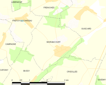
De onderstaande kaart toont de ligging van Muirancourt met de belangrijkste infrastructuur en aangrenzende gemeenten.
 |
Demografie
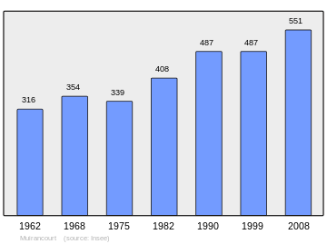
Onderstaande figuur toont het verloop van het inwonertal (bron: INSEE-tellingen).
Externe links
- (fr) Statistische informatie op de website van INSEE
Mediabestanden
Zie de categorie Muirancourt van Wikimedia Commons voor mediabestanden over dit onderwerp.
- ↑ Populations légales 2021.


