アサバスカ
アサバスカ Athabasca アサバスカ・ランディング(Athabasca Landing、1877–1912) | |
|---|---|
| Town of Athabasca | |
 | |
| 標語: 偉大な新しい北へのゲートウェイ(Gateway to the Great New North) | |
 町境 | |
| 座標:北緯54度43分11秒 西経113度17分08秒 / 北緯54.71972度 西経113.28556度 / 54.71972; -113.28556座標: 北緯54度43分11秒 西経113度17分08秒 / 北緯54.71972度 西経113.28556度 / 54.71972; -113.28556 | |
| 国 |  カナダ カナダ |
| 州 |  アルバータ州 アルバータ州 |
| 行政区 | アサバスカ郡 |
| 創設 | 1877[1] |
| 村制施行[2] | 1905年(アサバスカ・ランディングとして) |
| 面積 | |
| • 陸地 | 17.79 km2 |
| 標高 | 533 m |
| 人口 | |
| • 合計 | 2,759人 |
| • 密度 | 155.1人/km2 |
| 等時帯 | UTC-7 (MST) |
| • 夏時間 | UTC-6 (MDT) |
| ウェブサイト | [athabasca.ca 公式ウェブサイト] |
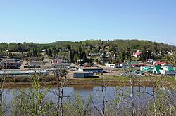
アサバスカ(英: Athabasca)は、カナダのアルバータ州北部、アサバスカ郡の町。アサバスカ郡の行政府がおかれている。
エドモントンからは約45km北にあり、アルバータ州道2号線とアルバータ州道55号線の交差する場所で、アサバスカ川の川岸にある。かつてはアサバスカ・ランディング(Athabasca Landing)と呼ばれていた[5]。

歴史
アサバスカの名はクリー族に発祥する。1889年ごろにはアサバスカ・ランディングと呼ばれ、1904年にアサバスカに改称された。このアルバータ、サスカチュワン北部の地域全体を「アサバスカ地域」と呼ぶ時代もあった[6]。
教育
- アサバスカ大学
脚注
- ^ “Brief History”. Town of Athabasca. 2013年3月20日時点のオリジナルよりアーカイブ。2013年3月6日閲覧。
- ^ “Location and History Profile: Town of Athabasca”. Alberta Municipal Affairs. p. 1 (2016年10月7日). 2016年10月13日閲覧。
- ^ “Population and dwelling counts: Canada, provinces and territories, and census subdivisions (municipalities)”. Statistics Canada (2022年2月9日). 2022年2月9日閲覧。
- ^ “Population and dwelling counts: Canada and population centres”. Statistics Canada (2022年2月9日). 2022年2月13日閲覧。
- ^ “Location and History Profile: Town of Athabasca”. Alberta Municipal Affairs (2013年6月14日). 2013年6月17日閲覧。
- ^ Hamilton, William (1978). The Macmillan Book of Canadian Place Names. Toronto: Macmillan. pp. 20. ISBN 0-7715-9754-1
外部リンク
- 公式ウェブサイト(英語)
- 表示
- 編集
典拠管理データベース | |
|---|---|
| 全般 |
|
| 国立図書館 |
|


