World Map at Lake Klejtrup
56°35′26″N 9°38′29″E / 56.59054°N 9.64147°E / 56.59054; 9.64147

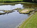
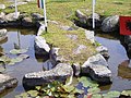
The World Map at Lake Klejtrup (Danish: Verdenskortet ved Klejtrup Sø) is a miniature world map built of stones and grass in Klejtrup Sø near the village of Klejtrup, Viborg Municipality, Denmark.
History
In 1943, Søren Poulsen, a local farmer, was working on the drainage of the surrounding meadows when he found a stone shaped like the Jutland peninsula. This inspired him to create a small world of his own.[1] During the winter months, with the use of primitive tools, he placed big stones carefully on the ice. When spring arrived, the stones could easily be tilted into place, and in this way the World Map took shape. Some of the stones used weighed more than 2 tonnes.[2]
Poulsen created the World Map between 1944 and 1969. It measures 45 by 90 metres (49 by 98 yards), covering an area of over 4000 square meters (1 acre).[1] [3] One 111-kilometre (69 mi) degree of latitude corresponds to 27 centimetres (11 inches) on the map.[1] [3] On Poulsen's map, Antarctica is not present and the Northern Hemisphere is marked in two places, ensuring a better impression of the correct distances between the countries to avoid the difficulties of spreading out our planet's globular shape.[3] Red poles mark the equator, and each country is represented by miniature flags, [4][2] which are updated yearly.[3] State borders in the United States of America are marked with yellow bricks; Poulsen lived 20 years in America.[3]
The map is the epicenter of a park, which has, among other attractions, a picnic area, a coffee shop and a playground.[5]
The World Map is an important attraction in the area,[6] and attracts about 40,000 visitors per year, most of them Danish.[7]
Gallery
-
 Denmark
 -
 The Americas
 -
 Insulindia, Australia and New Zealand
 -
 Asia and the Middle East
 -
 Italy
Italy


See also
References
- ^ a b c "The World Map at Lake Klejtrup". Amusing Planet. November 21, 2015. Retrieved September 9, 2016.
- ^ a b "Man Builds Entire World Map in His Back Yard". Ripley's Believe it or Not. Ripley Entertainment. December 2, 2015. Retrieved September 9, 2016.
- ^ a b c d e Jacobs, Frank. "A Very Danish Map of the World". Big Think. The Big Think Inc. Retrieved September 9, 2016.
- ^ "The World Map at Lake Klejtrup: A Danish farmer spent the last 25 years of his life building his own miniature version of the world". The Vintage News. Retrieved September 9, 2016.
- ^ "Verdenskortet ved Klejtrup Sø". Visit Viborg. Retrieved September 9, 2016.
- ^ "Verdenskortet". Atlas Obscura. Retrieved September 9, 2016.
- ^ Olsen, Sara Janner (May 2014). "Markedsføringsstrategi for Verdenskortet v/Klejtrup sø" (PDF) (in Danish). Aarhus: Aarhus University. Retrieved September 9, 2016.
External links
Wikimedia Commons has media related to World Map at Lake Klejtrup.
- Website
- v
- t
- e
Viborg Municipality
- Dollerup Hills
- Hald Lake
- Hjarbæk Fjord
- Klejtrup Lake
- Kongenshus Mindepark
- Ø Hills
- Stanghede
- Tange Lake
- Tjele Langsø
- Danish National Archives
- Skovgaard Museum
- Viborg Kunsthal
- Viborg Museum
- Viborg Theatre
- World Map at Lake Klejtrup
 Category
 | This article about a location in the Central Denmark Region is a stub. You can help Wikipedia by expanding it. |
- v
- t
- e


