Vigneulles-lès-Hattonchâtel
Commune in Grand Est, France

Coat of arms
Location of Vigneulles-lès-Hattonchâtel

(2020–2026) Jean-Claude Zingerlé[1]
1
(2021)[2]
55551 /55210
(avg. 259 m or 850 ft)
Vigneulles-lès-Hattonchâtel (French pronunciation: [viɲœl le atɔ̃ʃatɛl], literally Vigneulles near Hattonchâtel) is a commune in the Meuse department in Grand Est in north-eastern France.
The former towns of Billy-sous-les-Côtes, Creuë, Hattonchâtel, Hattonville, Saint-Benoît-en-Woëvre, and Viéville-sous-les-Côtes were joined to Vigneulles-lès-Hattonchâtel on 1 March 1973.
Gallery
-
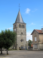 The bell tower of Vigneulles
 -
 Saint-Sabastian church (Hattonville).
 -
 Town hall
 -
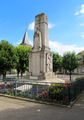 War memorial in Vigneulles


See also
References
- ^ "Répertoire national des élus: les maires". data.gouv.fr, Plateforme ouverte des données publiques françaises (in French). 2 December 2020.
- ^ "Populations légales 2021". The National Institute of Statistics and Economic Studies. 28 December 2023.
Wikimedia Commons has media related to Vigneulles-lès-Hattonchâtel.
- v
- t
- e
Communes of the Meuse department
- Abainville
- Abaucourt-Hautecourt
- Aincreville
- Amanty
- Ambly-sur-Meuse
- Amel-sur-l'Étang
- Ancemont
- Ancerville
- Andernay
- Apremont-la-Forêt
- Arrancy-sur-Crusnes
- Aubréville
- Aulnois-en-Perthois
- Autrécourt-sur-Aire
- Autréville-Saint-Lambert
- Avillers-Sainte-Croix
- Avioth
- Avocourt
- Azannes-et-Soumazannes
- Baâlon
- Badonvilliers-Gérauvilliers
- Bannoncourt
- Bantheville
- Bar-le-Ducpref
- Baudonvilliers
- Baudrémont
- Baulny
- Bazeilles-sur-Othain
- Bazincourt-sur-Saulx
- Beauclair
- Beaufort-en-Argonne
- Beaulieu-en-Argonne
- Beaumont-en-Verdunois
- Beausite
- Behonne
- Belleray
- Belleville-sur-Meuse
- Belrain
- Belrupt-en-Verdunois
- Beney-en-Woëvre
- Béthelainville
- Béthincourt
- Beurey-sur-Saulx
- Bezonvaux
- Biencourt-sur-Orge
- Billy-sous-Mangiennes
- Bislée
- Blanzée
- Boinville-en-Woëvre
- Boncourt-sur-Meuse
- Bonnet
- Bonzée
- Le Bouchon-sur-Saulx
- Bouconville-sur-Madt
- Bouligny
- Bouquemont
- Boureuilles
- Bovée-sur-Barboure
- Boviolles
- Brabant-en-Argonne
- Brabant-le-Roi
- Brabant-sur-Meuse
- Brandeville
- Braquis
- Bras-sur-Meuse
- Brauvilliers
- Bréhéville
- Breux
- Brieulles-sur-Meuse
- Brillon-en-Barrois
- Brixey-aux-Chanoines
- Brizeaux
- Brocourt-en-Argonne
- Brouennes
- Broussey-en-Blois
- Broussey-Raulecourt
- Bure
- Burey-en-Vaux
- Burey-la-Côte
- Buxières-sous-les-Côtes
- Buzy-Darmont
- Cesse
- Chaillon
- Chalaines
- Champneuville
- Champougny
- Chanteraine
- Chardogne
- Charny-sur-Meuse
- Charpentry
- Chassey-Beaupré
- Châtillon-sous-les-Côtes
- Chattancourt
- Chaumont-devant-Damvillers
- Chaumont-sur-Aire
- Chauvency-le-Château
- Chauvency-Saint-Hubert
- Chauvoncourt
- Cheppy
- Chonville-Malaumont
- Cierges-sous-Montfaucon
- Le Claon
- Clermont-en-Argonne
- Cléry-le-Grand
- Cléry-le-Petit
- Combles-en-Barrois
- Combres-sous-les-Côtes
- Commercysubpr
- Consenvoye
- Contrisson
- Courcelles-en-Barrois
- Courcelles-sur-Aire
- Courouvre
- Cousances-les-Forges
- Cousances-lès-Triconville
- Couvertpuis
- Couvonges
- Cuisy
- Culey
- Cumières-le-Mort-Homme
- Cunel
- Dagonville
- Dainville-Bertheléville
- Damloup
- Dammarie-sur-Saulx
- Damvillers
- Dannevoux
- Delouze-Rosières
- Delut
- Demange-Baudignécourt
- Dieppe-sous-Douaumont
- Dieue-sur-Meuse
- Dombasle-en-Argonne
- Dombras
- Dommartin-la-Montagne
- Dommary-Baroncourt
- Dompcevrin
- Dompierre-aux-Bois
- Domremy-la-Canne
- Doncourt-aux-Templiers
- Douaumont-Vaux
- Doulcon
- Dugny-sur-Meuse
- Dun-sur-Meuse
- Duzey
- Écouviez
- Écurey-en-Verdunois
- Eix
- Les Éparges
- Épiez-sur-Meuse
- Épinonville
- Érize-la-Brûlée
- Érize-la-Petite
- Érize-Saint-Dizier
- Erneville-aux-Bois
- Esnes-en-Argonne
- Étain
- Éton
- Étraye
- Euville
- Èvres
- Fains-Véel
- Flassigny
- Fleury-devant-Douaumont
- Foameix-Ornel
- Fontaines-Saint-Clair
- Forges-sur-Meuse
- Foucaucourt-sur-Thabas
- Fouchères-aux-Bois
- Frémeréville-sous-les-Côtes
- Fresnes-au-Mont
- Fresnes-en-Woëvre
- Froidos
- Fromeréville-les-Vallons
- Fromezey
- Futeau
- Génicourt-sur-Meuse
- Gercourt-et-Drillancourt
- Géry
- Gesnes-en-Argonne
- Geville
- Gimécourt
- Gincrey
- Girauvoisin
- Givrauval
- Gondrecourt-le-Château
- Gouraincourt
- Goussaincourt
- Gremilly
- Grimaucourt-en-Woëvre
- Grimaucourt-près-Sampigny
- Guerpont
- Gussainville
- Haironville
- Halles-sous-les-Côtes
- Han-lès-Juvigny
- Han-sur-Meuse
- Hannonville-sous-les-Côtes
- Harville
- Haudainville
- Les Hauts-de-Chée
- Haudiomont
- Haumont-près-Samogneux
- Heippes
- Hennemont
- Herbeuville
- Herméville-en-Woëvre
- Heudicourt-sous-les-Côtes
- Hévilliers
- Horville-en-Ornois
- Houdelaincourt
- Inor
- Ippécourt
- Iré-le-Sec
- L'Isle-en-Rigault
- Les Islettes
- Jametz
- Jonville-en-Woëvre
- Jouy-en-Argonne
- Julvécourt
- Juvigny-en-Perthois
- Juvigny-sur-Loison
- Kœur-la-Grande
- Kœur-la-Petite
- Labeuville
- Lachalade
- Lachaussée
- Lacroix-sur-Meuse
- Lahaymeix
- Lahayville
- Laheycourt
- Laimont
- Lamorville
- Lamouilly
- Landrecourt-Lempire
- Laneuville-au-Rupt
- Laneuville-sur-Meuse
- Lanhères
- Latour-en-Woëvre
- Lavallée
- Lavincourt
- Lavoye
- Lemmes
- Lérouville
- Levoncourt
- Lignières-sur-Aire
- Ligny-en-Barrois
- Liny-devant-Dun
- Lion-devant-Dun
- Lisle-en-Barrois
- Lissey
- Loisey
- Loison
- Longchamps-sur-Aire
- Longeaux
- Longeville-en-Barrois
- Loupmont
- Louppy-le-Château
- Louppy-sur-Loison
- Louvemont-Côte-du-Poivre
- Luzy-Saint-Martin
- Maizeray
- Maizey
- Malancourt
- Mandres-en-Barrois
- Mangiennes
- Manheulles
- Marchéville-en-Woëvre
- Marre
- Marson-sur-Barboure
- Martincourt-sur-Meuse
- Marville
- Maucourt-sur-Orne
- Maulan
- Mauvages
- Maxey-sur-Vaise
- Mécrin
- Méligny-le-Grand
- Méligny-le-Petit
- Menaucourt
- Ménil-aux-Bois
- Ménil-la-Horgne
- Ménil-sur-Saulx
- Merles-sur-Loison
- Milly-sur-Bradon
- Mogeville
- Mognéville
- Moirey-Flabas-Crépion
- Les Monthairons
- Montblainville
- Montbras
- Mont-devant-Sassey
- Montfaucon-d'Argonne
- Montiers-sur-Saulx
- Montigny-devant-Sassey
- Montigny-lès-Vaucouleurs
- Montmédy
- Montplonne
- Montsec
- Montzéville
- Moranville
- Morgemoulin
- Morley
- Mouilly
- Moulainville
- Moulins-Saint-Hubert
- Moulotte
- Mouzay
- Murvaux
- Muzeray
- Naives-en-Blois
- Naives-Rosières
- Naix-aux-Forges
- Nançois-le-Grand
- Nançois-sur-Ornain
- Nantillois
- Nant-le-Grand
- Nant-le-Petit
- Nantois
- Nepvant
- Nettancourt
- Le Neufour
- Neuville-en-Verdunois
- Neuville-lès-Vaucouleurs
- Neuville-sur-Ornain
- Neuvilly-en-Argonne
- Nicey-sur-Aire
- Nixéville-Blercourt
- Nonsard-Lamarche
- Nouillonpont
- Noyers-Auzécourt
- Nubécourt
- Olizy-sur-Chiers
- Ornes
- Osches
- Ourches-sur-Meuse
- Pagny-la-Blanche-Côte
- Pagny-sur-Meuse
- Pareid
- Parfondrupt
- Les Paroches
- Peuvillers
- Pierrefitte-sur-Aire
- Pillon
- Pintheville
- Pont-sur-Meuse
- Pouilly-sur-Meuse
- Pretz-en-Argonne
- Quincy-Landzécourt
- Raival
- Rambluzin-et-Benoite-Vaux
- Rambucourt
- Rancourt-sur-Ornain
- Ranzières
- Rarécourt
- Récicourt
- Récourt-le-Creux
- Reffroy
- Regnéville-sur-Meuse
- Rembercourt-Sommaisne
- Remennecourt
- Remoiville
- Resson
- Revigny-sur-Ornain
- Réville-aux-Bois
- Riaville
- Ribeaucourt
- Richecourt
- Rigny-la-Salle
- Rigny-Saint-Martin
- Robert-Espagne
- Les Roises
- Romagne-sous-les-Côtes
- Romagne-sous-Montfaucon
- Ronvaux
- Rouvres-en-Woëvre
- Rouvrois-sur-Meuse
- Rouvrois-sur-Othain
- Rumont
- Rupt-aux-Nonains
- Rupt-devant-Saint-Mihiel
- Rupt-en-Woëvre
- Rupt-sur-Othain
- Saint-Amand-sur-Ornain
- Saint-André-en-Barrois
- Saint-Aubin-sur-Aire
- Saint-Germain-sur-Meuse
- Saint-Hilaire-en-Woëvre
- Saint-Jean-lès-Buzy
- Saint-Joire
- Saint-Julien-sous-les-Côtes
- Saint-Laurent-sur-Othain
- Saint-Maurice-sous-les-Côtes
- Saint-Mihiel
- Saint-Pierrevillers
- Saint-Remy-la-Calonne
- Salmagne
- Samogneux
- Sampigny
- Sassey-sur-Meuse
- Saudrupt
- Saulmory-Villefranche
- Saulvaux
- Saulx-lès-Champlon
- Sauvigny
- Sauvoy
- Savonnières-devant-Bar
- Savonnières-en-Perthois
- Seigneulles
- Senon
- Senoncourt-lès-Maujouy
- Septsarges
- Sepvigny
- Seuil-d'Argonne
- Seuzey
- Silmont
- Sivry-la-Perche
- Sivry-sur-Meuse
- Sommedieue
- Sommeilles
- Sommelonne
- Sorbey
- Sorcy-Saint-Martin
- Les Souhesmes-Rampont
- Souilly
- Spincourt
- Stainville
- Stenay
- Taillancourt
- Tannois
- Thierville-sur-Meuse
- Thillombois
- Thillot
- Thonne-la-Long
- Thonne-le-Thil
- Thonne-les-Près
- Thonnelle
- Tilly-sur-Meuse
- Trémont-sur-Saulx
- Trésauvaux
- Tréveray
- Les Trois-Domaines
- Tronville-en-Barrois
- Troussey
- Troyon
- Ugny-sur-Meuse
- Vacherauville
- Vadelaincourt
- Vadonville
- Val-d'Ornain
- Valbois
- Varennes-en-Argonne
- Varnéville
- Vassincourt
- Vaubecourt
- Vaucouleurs
- Vaudeville-le-Haut
- Vaudoncourt
- Vauquois
- Vaux-lès-Palameix
- Vavincourt
- Velaines
- Velosnes
- Verdunsubpr
- Verneuil-Grand
- Verneuil-Petit
- Véry
- Vigneulles-lès-Hattonchâtel
- Vigneul-sous-Montmédy
- Vignot
- Villécloye
- Ville-devant-Belrain
- Ville-devant-Chaumont
- Ville-en-Woëvre
- Villeroy-sur-Méholle
- Villers-aux-Vents
- Villers-devant-Dun
- Villers-le-Sec
- Villers-lès-Mangiennes
- Villers-sous-Pareid
- Villers-sur-Meuse
- Ville-sur-Cousances
- Ville-sur-Saulx
- Villotte-devant-Louppy
- Villotte-sur-Aire
- Vilosnes-Haraumont
- Vittarville
- Void-Vacon
- Vouthon-Bas
- Vouthon-Haut
- Waly
- Warcq
- Watronville
- Wavrille
- Willeroncourt
- Wiseppe
- Woël
- Woimbey
- Xivray-et-Marvoisin
- pref: prefecture
- subpr: subprefecture
Authority control databases | |
|---|---|
| International |
|
| National |
|
| Geographic |
|
 | This Meuse geographical article is a stub. You can help Wikipedia by expanding it. |
- v
- t
- e


