Tuncurry, New South Wales
Town in New South Wales, Australia
32°10′30″S 152°29′56″E / 32.17500°S 152.49889°E / -32.17500; 152.49889
- 307 km (191 mi) NNE of Sydney
- 165 km (103 mi) NNE of Newcastle
- 631 km (392 mi) S of Brisbane
- 35 km (22 mi) S of Taree
- 63 km (39 mi) NE of Bulahdelah
| Localities around Tuncurry: | ||
| Failford | Darawank | Tasman Sea |
| Nabiac | Tuncurry | Tasman Sea |
| Wallis Island | Forster | Forster |
Tuncurry is a coastal town in the Mid North Coast region of New South Wales, Australia, in the Mid-Coast Council LGA, about 307 km (191 mi) north north east of Sydney. It is immediately adjacent to its twin town of Forster, which is the larger of the two towns.
At the 2016 census, the Forster–Tuncurry area had a population of 19,918 people.[2] This number grows considerably in the tourist season. The population of Tuncurry alone was 6,376.[1]
History
In 1875, John Wright was the first white settler in Tuncurry.[3][4] The first land grant in this area was in 1875. The settlement was originally called North Shore and then North Forster and was renamed Tuncurry meaning "plenty of fish" in 1891 and then proclaimed a village in 1893.[5]
The area was well known in the early days for its timber cutting and sawmills. Timber was collected from the lakes and rivers by the logpunts (droghers).
A bridge over the Coolongolook River that marks the entrance to Wallis Lake was built in 1959 linking Forster and Tuncurry and replacing the punt service that had operated since 1890.
Tourism
Because of its relatively close driving proximity to Sydney, Forster–Tuncurry has established itself as a popular summer holiday destination, where in the hotter months, the population swells considerably. The school holidays in the colder months also bring large numbers of holidaymakers.
Tuncurry's Nine Mile Beach is a popular swimming, surfing and fishing spot. Tuncurry Rockpool is a netted swimming enclosure, formed by breakwalls which mark the entrance to Wallis Lake. Tuncurry's lakefront areas are characterised by wharves and jetties which provide mooring for fishing boats and pleasure craft.
Sporting Clubs
- The Tuncurry Golf Course is part of the Forster Tuncurry Golf Club[6]
- The Tuncurry Forster Football Club is a soccer club home to the Tuncurry Tigers[7]
- The Forster Tuncurry Rugby League Football Club is home to the Forster Tuncurry Hawkes
- The Tuncurry Forster Jockey Club has regular horse racing events[8]
- The Forster Tuncury Touch Association offers touch football for all levels[9]
- The Tuncurry Beach Bowling Club offers lawn bowling to the area[10]
See also
Gallery
-
 Pelican gather at the public boat ramp in Tuncurry
 -
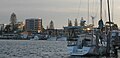 Fishing vessels moored at Tuncurry
 -
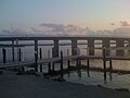 View of bridge connecting Forster to Tuncurry.


References
- ^ a b Australian Bureau of Statistics (28 June 2022). "Tuncurry". 2021 Census QuickStats. Retrieved 13 March 2024.

- ^ Australian Bureau of Statistics (27 June 2017). "Forster–Tuncurry (Urban Centre/Locality)". 2016 Census QuickStats. Retrieved 21 March 2013.
- ^ Great Lakes Historical and Maritime Museum. "TUNCURRY'S WORKING WATERFRONT – Wright's mill and shipyard". Retrieved 15 March 2018.
- ^ North Coast Run: Men and Ships of the New South Wales North Coast M. Richards P94 - 95 ISBN 978-0908031108
- ^ "Heritage & Culture". Great Lakes Tourism. Retrieved 3 May 2009.
- ^ "Forster Tuncurry Golf - Forster, NSW - Tuncurry Course". www.forstertuncurrygolf.com.au. Retrieved 7 March 2022.
- ^ "Tuncurry Forster Football Club". Tuncurry Forster Football Club. Retrieved 7 March 2022.
- ^ "Horse Racing Tuncurry Forster". Horse Racing Tuncurry Forster. Retrieved 7 March 2022.
- ^ "Forster Tuncurry Touch Association". www.facebook.com. Retrieved 7 March 2022.
- ^ "Home". Tuncurry Beach Bowling Club. Retrieved 7 March 2022.
External links
Wikimedia Commons has media related to Tuncurry, New South Wales.
- Forster-Tuncurry Visitor Guide - www.Tuncurry.com.au
- MidCoast Council
- v
- t
- e
Towns, suburbs and localities of Mid-Coast Council, in the Hunter & Mid North Coast Regions, New South Wales
and localities
- Alderley
- Alderley Creek
- Allworth
- Back Creek
- Bakers Creek
- Barrington
- Baxters Ridge
- Belbora
- Bennetts Head
- Bennys Tops
- Berrico
- Bindera
- Black Head
- Blueys Beach
- Bobin
- Bohnock
- Bombah Point
- Boolambayte
- Boomerang Beach
- Booral
- Bootawa
- Booti Booti
- Bowman
- Bowman Farm
- Bretti
- Brimbin
- Bucca Wauka
- Bulahdelah
- Bulby Brush
- Bulga Forest
- Bulliac
- Bundabah
- Bundook
- Bungwahl
- Bunyah
- Bunyah Upper
- Burgess Beach
- Burraduc
- Burrell Creek
- Cabbage Tree Island
- Caffreys Flat
- Callaghans Creek
- Caparra
- Cape Hawke
- Caramea
- Carrington
- Cedar Party
- Cells River
- Charlottes Bay
- Clareval
- Cobark
- Coneac
- Coolongolook
- Coomba
- Coomba Bay
- Coomba Park
- Coopernook
- Cooplacurripa
- Copeland
- Coralville
- Corroboree Flat
- Craven
- Craven Plateau
- Cravens Creek
- Crawford River
- Croki
- Crowdy Bay National Park
- Crowdy Head
- Cundle Flat
- Cundletown
- Cureeki Creek
- Curricabark
- Darawank
- Dewitt
- Dewrang
- Diamond Beach
- Dingo Forest
- Dirty Creek
- Dollys Flat
- Doon Ayre
- Dumaresq Island
- Dungog
- Dyers Crossing
- Elands
- Elizabeth Beach
- Failford
- Faulkland
- Fernhill
- Firefly
- Forbesdale
- Forster
- Forster Keys
- Forster Waters
- Friendship Key
- Gangat
- Gereeba Island
- Ghinni Ghinni
- Giro
- Girvan
- Glen Ward
- Glenthorne
- Gloucester
- Gloucester River
- Gloucester South
- Gloucester Tops
- Green Point
- Hallidays Point
- Hannam Vale
- Harrington
- Hawks Nest
- Heatherdale
- Hillville
- Invergordon
- Johns River
- Johnsons Creek
- Jones Island
- Karaak Flat
- Karuah
- Kauthi
- Khatambuhl
- Kia Ora
- Killabakh
- Killawarra
- Kimbriki
- Kippaxs
- Kiwarrak
- Knorrit Flat
- Knorrit Forest
- Koorainghat
- Krambach
- Kundibakh
- Kundle Kundle
- Langley Vale
- Lansdowne
- Lansdowne Forest
- Legges Camp
- Lime Kiln
- Limeburners Creek
- Lower Bowman
- Manning Point
- Mares Run
- Markwell
- Marlee
- Maudville
- Mayers Flat
- Melinga
- Mernot
- Milbrook
- Mill Creek Upper
- Minimbah
- Mitchells Island
- Mograni Creek
- Mograni
- Mondrook
- Monkerai
- Mooral Creek
- Moorland
- Moppy
- Moto
- Mount George
- Mount Peerless
- Mungo Brush
- Myall Lakes
- Myall Upper
- Myra
- Nabiac
- Nerong
- New Forster
- Newells Creek
- Nooroo
- North Arm Cove
- North Pindimar
- Nugra
- Nugramudgee
- Number One
- Old Bar
- Oxley Island
- Pacific Palms
- Pampoolah
- Pindimar
- Pioneer Park
- Pipers Bay
- Pitlochry
- Possum Brush
- Purfleet
- Rainbow Flat
- Rawdon Vale
- Red Head
- Rocky Crossing
- Rookhurst
- Rosenthal
- Saltwater
- Sandbar
- Seal Rocks
- Smiths Lake
- South Pindimar
- Stewarts River
- Stratford
- Stratford South
- Strathcedar
- Stroud
- Stroud Road
- Sugarloaf Point
- Tahlee
- Tallwoods Village
- Tamboy
- Taravale
- Tarbuck Bay
- Taree
- Taree South
- Tea Gardens
- Telegherry
- Terreel
- The Bight
- The Branch
- Tibbuc
- Tinonee
- Tiona
- Tipperary
- Titaatee Creek
- Topi Topi
- Tugrabakh
- Tuncurry
- Upper Bowman
- Upper Karuah River
- Upper Lansdowne
- Upper Monkerai
- Violet Hill
- Waitui
- Wallabi Point
- Wallamba Island
- Wallanbah
- Wallingat
- Wallingat River
- Wallis Island
- Wallis Lake
- Wang Wauk
- Wapra
- Wards River
- Warranulla
- Washpool
- Wattley Hill
- Waukivory
- Waukivory Upper
- Weismantels
- Wherrol Flat
- Whoota
- Willina
- Winda Woppa
- Wingham
- Wirradgurie
- Woko
- Wootton
- Yagon
- Yagon Beach
- Yarratt Forest
- Yumbunga
other waterways
- Avon River
- Barnard River
- Barrington River
- Bowman River
- Coolongolook River
- Cooplacurripa River
- Crawford River
- Curricabark River
- Gloucester River
- Karuah River
- Mammy Johnsons River
- Manning River
- Myall Lakes
- Myall River
- Smiths Lake
- Telegherry River
- The Branch River
- Wallamba River
- Wallingat River
- Wallis Lake
- Wards River
points of interest
- Broughton Island
- Cape Hawke
- Gloucester Tops
- Mitchells Island
- Oxley Island
- Port Stephens
- Singing Bridge
- Tahlee historic property
- Tops to Myall Heritage Trail
Authority control databases | |
|---|---|
| International |
|
| National |
|


