Timia
Commune and town in Agadez Region, Niger
18°6′52″N 8°46′45″E / 18.11444°N 8.77917°E / 18.11444; 8.77917 Niger
Niger (2012)
Timia is a small town and commune in northern Niger, situated at an oasis in the Aïr Mountains, Agadez Region, Arlit Department. Visitors come to the Tuareg town to see a seasonal waterfall, a former French fort and the nearby ruined town of Assodé.[1] As of 2012, the commune had a total population of 19,076 people.[2][3]
Timia lies south of Iferouane and north of Agadez. The main town lies around 3 km from a stone guelta oasis, which holds water year round. It is also known for its fruit trees, an unusual sight in the Saharan regions of northern Niger.[4]
Gallery
-
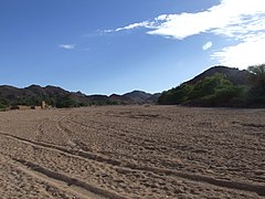
 The valleys of Timia
 -
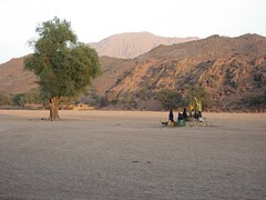
 The Oasis of Timia
 -
 In the valley
 -
 Well in Timia


References
- ^ Decalo, Samuel (1997). Historical Dictionary of the Niger (3rd ed.). Boston & Folkestone: Scarecrow Press. ISBN 0-8108-3136-8.
- ^ "Niger: Municipal Division (Departments and Communes) - Population Statistics, Charts and Map". www.citypopulation.de. Retrieved 2024-02-21.
- ^ "Annuaires_Statistiques" (PDF). Institut National de la Statistique. Retrieved 2 May 2013.
- ^ Geels, Jolijn (2006). Niger. Chalfont St Peter, Bucks / Guilford, Connecticut: Bradt UK / Globe Pequot Press. ISBN 978-1-84162-152-4.
- v
- t
- e
Capital: Niamey
- Abalak
- Agadez
- Aguie
- Arlit
- Bilma
- Birni N'Gaoure
- Birni-N'Konni
- Bouza
- Dakoro
- Diffa
- Dogondoutchi
- Dosso
- Filingué
- Gaya
- Guidanroumdji
- Goure
- Illela
- Keita
- Kollo
- Loga
- Madaoua
- Madarounfa
- Magaria
- Maine-Soroa
- Maradi
- Matameye
- Mayahi
- Mirriah
- N'guigmi
- Niamey
- Commune I
- II
- III
- IV
- V
- Ouallam
- Say
- Tahoua
- Tanout
- Tchin-Tabaraden
- Tchirozerine
- Tessaoua
- Téra
- Tibiri
- Tillabéri
- Zinder
- Abala
- Aderbissinat
- Adjekoria
- Affala
- Akoubounou
- Albarkaram
- Alakoss
- Allakaye
- Allela
- Anzourou
- Attantane
- Ayerou
- Azagor
- Azarori
- Azeye
- Babankatami
- Badaguichiri
- Bader Goula
- Bagaroua
- Bambeye
- Bana
- Bande
- Bangui
- Banibangou
- Bankilare
- Baoudetta
- Barmou
- Bazaga
- Bengou
- Bermo
- Bibiyergou
- Birni Lalle
- Bitinkodji
- Bosso
- Boune
- Chadakori
- Chetimari
- Dabaga
- Dakoussa
- Damagaram Takaya
- Dan-Barto
- Dan-Goulbi
- Dan-Issa
- Dan-Kassari
- Dannet
- Dantchiao
- Daouche
- Dargol
- Deoule
- Dessa
- Diagourou
- Diantchandou
- Dingazi
- Dirkou
- Dioundiou
- Djado
- Djiratawa
- Dogo
- Dogo-Dogo
- Dogonkiria
- Doguerawa
- Doumega
- Doungou
- Droum
- Dungass
- El Allassane Maireyrey
- Fabidji
- Fachi
- Fakara
- Falenko
- Falmey
- Falwel
- Farey
- Foulatari
- Gabi
- Gababedji
- Gaffati
- Galma Koudawatche
- Gamou
- Gangara
- Gangara
- Garagoumsa
- Garhanga
- Garankedey
- Gazaoua
- Golle
- Goroubankassam
- Gorouol
- Gothèye
- Gouchi
- Goudoumaria
- Goûgaram
- Gouna
- Guecheme
- Gueskerou
- Guidan Amoumoune
- Guidan Sori
- Guidiguir
- Guidimouni
- Guilladje
- Hamdallaye
- Hamdara
- Harikanassou
- Hawandawaki
- Ibrohamane
- Ichirnawa
- Iferouane
- Imanan
- Inates
- In-Gall
- Issawane
- Kablewa
- Kao
- Kalfou
- Kanan-Bakache
- Kankandi
- Kantche
- Karakara
- Kargiubangou
- Karma
- Karofane
- Kelle
- Kieche
- Kiota
- Kirtachi
- Kokorou
- Kolleram
- Koona
- Korahane
- Koré Maïroua
- Korgom
- Kornaka
- Kouré
- Kourfeye
- Kourni
- Kourteye
- Koygolo
- Kwaya
- Libore
- Maijirgiu
- Maiyara
- Makalondi
- Malawa
- Malbaza
- Matankari
- Mehana
- Moa
- Mokko
- N'Dounga
- N'Gonga
- N'Gourti
- N'Guelbély
- Namaro
- Ollelewa
- Ourafane
- Ouro Gueladjo
- Ourno
- Roumboui
- Sabon-Guida
- Sabon-Machi
- Sae Saboua
- Safo
- Sakoira
- Sambera
- Sanam
- Sarkin Haoussa
- Sarkin Yamma
- Sassoumbroum
- Simiri
- Sinder
- Sokorbe
- Soucoucoutane
- Tabalak
- Tabelot
- Tabotaki
- Tagazar
- Tagriss
- Tajae
- Takanamat
- Tama
- Tamaske
- Tamaya
- Tamou
- Tanda
- Tarka
- Tassara
- Tchadoua
- Tchake
- Tebaram
- Tenhya
- Tesker
- Tessa
- Tibiri (Doutchi)
- Timia
- Tillia
- Tirmini
- Tombokoirey I
- Tombokoirey II
- Tondikandia
- Tondikiwindi
- Torodi
- Toumour
- Tounounga
- Tsaouni
- Tsernaoua
- Wacha
- Wame
- Yaouri
- Yekoua
- Yelou
- Youri
- Zermou
Authority control databases | |
|---|---|
| International |
|
| National |
|
 | This Niger location article is a stub. You can help Wikipedia by expanding it. |
- v
- t
- e


