The Hill, New South Wales
Suburb of Newcastle, New South Wales, Australia
32°55′54″S 151°46′34″E / 32.93167°S 151.77611°E / -32.93167; 151.77611- 159 km (99 mi) NNE of Sydney
- 0 km (0 mi) from Newcastle
| Mean max temp | Mean min temp | Annual rainfall |
| 25.5 °C 78 °F | 8.4 °C 47 °F | 1,139.5 mm 44.9 in |
| Suburbs around The Hill: | ||
| Newcastle, Cooks Hill | Newcastle | Newcastle |
| Cooks Hill | The Hill | Newcastle |
| Bar Beach | Tasman Sea | Newcastle, Tasman Sea |
The Hill is an inner city, residential suburb of Newcastle, in the Hunter Region of New South Wales, Australia, located immediately south of Newcastle's central business district.[2][6] The Hill is filled with historic Victorian terraces and is the site of a historic convict prison block.[citation needed] As of January 2021, the average house price in The Hill was A$1.92m.[7]
History
The Aboriginal people, in this area, the Awabakal, were the previous people of this land.[8] The Hill was first known as Church Hill then Prospect Hill.[9] It was one of the earliest settled areas of Newcastle and the site of the first town plan laid out by Henry Dangar in 1823.[9] The first railway was located there, starting at AA Coy's A Pit just off Church Street[10]
The Boltons
The site was originally used as a mine with two engines creating coal fired stream.[10] A series of four homes in San Francisco style.[10] They are timber houses designed by Frederick B Menkins and built by G.W Brewer in 1904.[10] Each house has 4 bedrooms and bathroom is the last selling for $1,725,00.[11]
Heritage listings
The Hill has a number of heritage-listed sites, including:
- 51 Brown Street: Newcastle Reservoirs[12]
- 51 Church Street: Woodlands[13]
- 52a Church Street: Christ Church Cathedral[14]
- 52a Church Street: Horbury Hunt Hall[15]
Gallery
Wikimedia Commons has media related to The Hill, New South Wales.
-
 Residence building, which is part of St Mary's Star of the Sea Church
 -
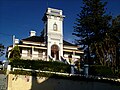 Jesmond House is an Italianate mansion of the 1880s with significant historic associations with Newcastle.
 -
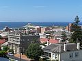 Looking east from Jesmond House with Nobbys Head and Stockton Beach in the background.
 -
 Christchurch Cathedral
 -
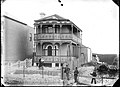 Tyrrell Street house, Newcastle, NSW, 21 September 1887


Notes
- ^ Area calculation is based on 1:100000 map 9232 NEWCASTLE.
References
- ^ Australian Bureau of Statistics (27 June 2017). "The Hill (State Suburb)". 2016 Census QuickStats. Retrieved 9 February 2018.

- ^ a b c "Suburb Search – Local Council Boundaries – Hunter (HT) – Newcastle City Council". New South Wales Division of Local Government. Retrieved 21 January 2009.
- ^ a b "The Hill". Geographical Names Register (GNR) of NSW. Geographical Names Board of New South Wales. Retrieved 21 January 2009.
- ^ "Newcastle". New South Wales Electoral Commission. Retrieved 23 November 2019.
- ^ "Newcastle". Australian Electoral Commission. 19 October 2007. Retrieved 21 January 2009.
- ^ "The Hill". Land and Property Management Authority - Spatial Information eXchange. New South Wales Land and Property Information. Retrieved 21 January 2009.
- ^ "The Hill suburb profile @ domain.com.au". domain.com.au. Retrieved 21 January 2009.
- ^ "Aboriginal Culture". City of Newcastle.
- ^ a b FEATURE, CARRIE FELLNER | A. DOMAIN ADVERTISING (6 March 2017). "Suburb profile: The Hill". Newcastle Herald. Retrieved 28 October 2020.
- ^ a b c d jonruwolt (12 September 2018). "Boltons, the Hill, Newcastle". Federation Home. Retrieved 31 March 2021.
- ^ "3 Menkens Lane, The Hill NSW 2300 – House for Sale | Allhomes". allhomes.com.au. Retrieved 31 March 2021.
- ^ "Newcastle Reservoirs Site". New South Wales State Heritage Register. Department of Planning & Environment. H02001. Retrieved 18 February 2020.
 Text is licensed by State of New South Wales (Department of Planning and Environment) under CC-BY 4.0 licence.
 - ^ "Woodlands". New South Wales State Heritage Register. Department of Planning & Environment. H00306. Retrieved 18 May 2018. Text is licensed by State of New South Wales (Department of Planning and Environment) under CC-BY 4.0 licence.
- ^ "Christ Church Cathedral, Movable Collections, Cemetery and Park". New South Wales State Heritage Register. Department of Planning & Environment. H01858. Retrieved 18 May 2018. Text is licensed by State of New South Wales (Department of Planning and Environment) under CC-BY 4.0 licence.
- ^ "Anglican Cathedral Hall, Christ Church". New South Wales State Heritage Register. Department of Planning & Environment. H00156. Retrieved 18 May 2018. Text is licensed by State of New South Wales (Department of Planning and Environment) under CC-BY 4.0 licence.
- "Newcastle Nobbys Signal Station AWS". Climate statistics for Australian locations. Bureau of Meteorology. Retrieved 21 January 2009.
- v
- t
- e
Towns, suburbs & localities of the City of Newcastle, New South Wales
& localities
- Adamstown
- Adamstown Heights
- Bar Beach
- Beresfield
- Birmingham Gardens
- Black Hill
- Broadmeadow
- Callaghan
- Carrington
- Cooks Hill
- Elermore Vale
- Fletcher
- Georgetown
- Hamilton
- Hamilton East
- Hamilton North
- Hamilton South
- Hexham
- The Hill
- Islington
- Jesmond
- The Junction
- Kooragang
- Kotara
- Lambton
- Lenaghan
- Maryland
- Maryville
- Mayfield
- Mayfield East
- Mayfield North
- Mayfield West
- Merewether
- Merewether Heights
- Minmi
- New Lambton
- New Lambton Heights
- Newcastle
- Newcastle East
- Newcastle West
- North Lambton
- Rankin Park
- Sandgate
- Shortland
- Stockton
- Tarro
- Tighes Hill
- Wallsend
- Warabrook
- Waratah
- Waratah West
- Wickham
other waterways
- Glenrock Lagoon
- Hunter River
- Williams River
points of interest
- Beaumont Street
- Broadmeadow Basketball Stadium
- Christ Church Cathedral
- Fernleigh Track
- Fort Scratchley
- Hunter Ice Skating Stadium
- Hunter Street
- John Hunter Hospital
- Mount Sugarloaf
- Newcastle City Hall
- Newcastle Civic Theatre
- Newcastle Court House
- Newcastle Customs House
- Newcastle Entertainment Centre
- Newcastle International Sports Centre
- Newcastle Museum
- Newcastle Street Circuit
- Nobbys Head
- Queens Wharf
- Royal Newcastle Hospital
- State Dockyard
- Stockton Beach
- Stockton Bridge
- Tourle Street Bridge
- University of Newcastle
- Victoria Theatre
 | This City of Newcastle geography article is a stub. You can help Wikipedia by expanding it. |
- v
- t
- e


