Tepic
You can help expand this article with text translated from the corresponding article in Spanish. (June 2012) Click [show] for important translation instructions.
- View a machine-translated version of the Spanish article.
- Machine translation, like DeepL or Google Translate, is a useful starting point for translations, but translators must revise errors as necessary and confirm that the translation is accurate, rather than simply copy-pasting machine-translated text into the English Wikipedia.
- Do not translate text that appears unreliable or low-quality. If possible, verify the text with references provided in the foreign-language article.
- You must provide copyright attribution in the edit summary accompanying your translation by providing an interlanguage link to the source of your translation. A model attribution edit summary is
Content in this edit is translated from the existing Spanish Wikipedia article at [[:es:Tepic]]; see its history for attribution. - You may also add the template
{{Translated|es|Tepic}}to the talk page. - For more guidance, see Wikipedia:Translation.
City in Nayarit, Mexico

Coat of arms
21°30′30″N 104°53′35″W / 21.50833°N 104.89306°W / 21.50833; -104.89306
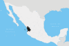
 Mexico
 Nayarit
Morena
PVEM
PT
Panal

(2010)
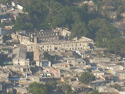
Tepic (Spanish pronunciation: [teˈpik] ⓘ) is the capital and largest city of the western Mexican state of Nayarit, as well as the seat of the Tepic Municipality.
Located in the central part of the state, it stands at an altitude of 915 metres (3,002 ft) above sea level, on the banks of the Río Mololoa and the Río Tepic, approximately 225 kilometres (140 mi) north-west of Guadalajara, Jalisco. Nearby are the volcanoes of San Juan, Las Navajas, and Sangangüey. Tepic is the primary urban center of this rich agricultural region; major crops include sugarcane, tobacco and citrus fruits.
The city was founded in 1531 as Villa del Espíritu Santo de la Mayor España.
Population
Indigenous population
Tepic has the second-largest indigenous population in the State of Nayarit, 4,375. The most prominent groups among them are the Huichol or Wixárika[1] (3,276), Cora (527) and Purépecha (101).
Religion

Catholicism is the most prominent religion in Tepic with 94.2% of the population. Its Catedral de la Purísima Concepción, dedicated to the Immaculate Conception, is the cathedral episcopal see of the Roman Catholic Diocese of Tepic, a suffragan see in the ecclesiastical province of the Archdiocese of Guadalajara.
Notable people
- Juan Escutia: Boy hero of the Battle of Chapultepec. Born in Tepic, between 1828 and 1832, on the morning of 13 September 1847, he fought to prevent invading U.S. forces from capturing Chapultepec Castle in Mexico City. After a brave defense, he is reported to have wrapped himself in the national flag and leaped to his death.
- Luis E. Miramontes: Chemist, co-inventor of the first contraceptive pill
- Amado Nervo: Poet and diplomat.
- Antonio Rivas Mercado.
- Emilia Ortiz: Contemporary painter, caricaturist and poet, after whom the major downtown Centro de Arte Contemporaneo Emilia Ortiz has been named.
- Gustavo Ayón: NBA basketball player
- Francisco Guerrero: Mayor of San Francisco, 1836-1842.
- Luis Ernesto Franco: Mexican actor.
- Joaquín Cosío: Mexican actor.
- Manuel Lozada.
Sports
Nayarit had small stadiums built for football and baseball. Both now demolished, there are plans to construct new, modern, and bigger stadiums; the state has three sport private clubs. There are multiple football fields and places to play "cascaritas" (pick-up games), indoor football courts, a basketball center and gym (with wooden flooring), several volleyball courts, and a bowling alley. In addition to common sports, in the city's main park there is an olympic swimming pool and a squash field. In Tepic, tennis is a popular sport, but the most popular is football (soccer). Futsal is also commonly played in the city. The city also has a bullring, as do most Mexican cities. Tepic has several state teams, one or more for each sport. Both the football and the basketball teams are named "Coras".
Geography
Located in the central part of the state, it stands at an altitude of 915 metres (3,002 ft) above sea level, on the banks of the Río Mololoa and the Río Tepic, approximately 225 kilometres (140 mi) north-west of Guadalajara, Jalisco. Nearby are the extinct Sangangüey volcano and its crater lake.
Climate
Tepic has a humid subtropical climate (Köppen climate classification Cwa), with most rain falling in the wet season from April to November, sometimes in December.
| Climate data for Tepic (1951–2010) | |||||||||||||
|---|---|---|---|---|---|---|---|---|---|---|---|---|---|
| Month | Jan | Feb | Mar | Apr | May | Jun | Jul | Aug | Sep | Oct | Nov | Dec | Year |
| Record high °C (°F) | 31.5 (88.7) | 33.5 (92.3) | 34.5 (94.1) | 38.0 (100.4) | 35.0 (95.0) | 39.0 (102.2) | 37.5 (99.5) | 38.5 (101.3) | 35.2 (95.4) | 39.5 (103.1) | 36.0 (96.8) | 36.5 (97.7) | 39.5 (103.1) |
| Mean daily maximum °C (°F) | 24.6 (76.3) | 25.6 (78.1) | 26.8 (80.2) | 28.7 (83.7) | 30.0 (86.0) | 29.2 (84.6) | 28.2 (82.8) | 28.2 (82.8) | 28.0 (82.4) | 27.8 (82.0) | 27.1 (80.8) | 25.3 (77.5) | 27.5 (81.5) |
| Daily mean °C (°F) | 16.3 (61.3) | 16.6 (61.9) | 17.6 (63.7) | 19.4 (66.9) | 21.4 (70.5) | 23.3 (73.9) | 23.4 (74.1) | 23.3 (73.9) | 23.3 (73.9) | 21.9 (71.4) | 19.3 (66.7) | 17.5 (63.5) | 20.3 (68.5) |
| Mean daily minimum °C (°F) | 8.0 (46.4) | 7.6 (45.7) | 8.4 (47.1) | 10.1 (50.2) | 12.9 (55.2) | 17.4 (63.3) | 18.5 (65.3) | 18.5 (65.3) | 18.5 (65.3) | 16.0 (60.8) | 11.5 (52.7) | 9.7 (49.5) | 13.1 (55.6) |
| Record low °C (°F) | 1.5 (34.7) | −0.4 (31.3) | 1.0 (33.8) | 0.0 (32.0) | 5.5 (41.9) | 8.0 (46.4) | 12.5 (54.5) | 10.0 (50.0) | 11.0 (51.8) | 6.0 (42.8) | 4.0 (39.2) | 1.5 (34.7) | −0.4 (31.3) |
| Average precipitation mm (inches) | 29.5 (1.16) | 10.1 (0.40) | 7.4 (0.29) | 9.1 (0.36) | 8.9 (0.35) | 169.7 (6.68) | 378.6 (14.91) | 285.6 (11.24) | 221.5 (8.72) | 72.9 (2.87) | 17.5 (0.69) | 29.1 (1.15) | 1,239.9 (48.81) |
| Average precipitation days (≥ 0.1 mm) | 2.6 | 1.2 | 0.4 | 0.6 | 0.8 | 10.7 | 22.2 | 20.9 | 18.1 | 7.3 | 1.8 | 2.8 | 89.4 |
| Average relative humidity (%) | 68 | 66 | 64 | 62 | 65 | 73 | 78 | 79 | 79 | 76 | 71 | 69 | 71 |
| Mean monthly sunshine hours | 229 | 247 | 298 | 305 | 321 | 234 | 186 | 192 | 183 | 236 | 254 | 226 | 2,911 |
| Source 1: Servicio Meteorológico Nacional (humidity 1981–2000)[2][3][4] | |||||||||||||
| Source 2: Ogimet (sun 1981–2010)[5] | |||||||||||||
Transport
Tepic is served by Tepic International Airport, with two commercial passenger airlines flying to it.
Twin towns – sister cities
 Havana, Cuba
 Paramount, California, United States
 Caborca, Sonora, Mexico
- Compostela, Nayarit, Mexico


See also
References
- ^ República, Biblioteca de Publicaciones Oficiales del Gobierno de la. "Wixárika, un pueblo en comunicación". gob.mx (in Spanish). Retrieved 2021-03-04.
- ^ "Estado de Nayarit–Estacion: Tepic". NORMALES CLIMATOLÓGICAS 1951–2010 (in Spanish). Servicio Meteorológico Nacional. Archived from the original on 3 March 2016. Retrieved 6 May 2015.
- ^ "Extreme Temperatures and Precipitation for Tepic 1950–1991" (in Spanish). Servicio Meteorológico Nacional. Archived from the original on 3 March 2016. Retrieved 6 May 2015.
- ^ "NORMALES CLIMATOLÓGICAS 1981–2000" (PDF) (in Spanish). Servicio Meteorológico Nacional. Archived from the original (PDF) on 3 March 2016. Retrieved 6 May 2015.
- ^ "CLIMAT summary for 76556: Tepic, Nay. (Mexico) – Section 2: Monthly Normals". CLIMAT monthly weather summaries. Ogimet. Retrieved 20 January 2019.
Sources and external links
Wikimedia Commons has media related to Tepic.
 Mexico portal

- Link to tables of population data from Census of 2005 INEGI: Instituto Nacional de Estadística, Geografía e Informática
- (in Spanish) Nayarit Enciclopedia de los Municipios de México
- (in Spanish) Official website (Ayuntamiento de Tepic)
- v
- t
- e
State of NayaritTepic (capital)
and
municipal seats
- Acaponeta (Acaponeta)
- Ahuacatlán (Ahuacatlán)
- Amatlán de Cañas (Amatlán de Cañas)
- Bahía de Banderas (Valle de Banderas)
- Compostela (Compostela)
- El Nayar (Jesús María)
- Huajicori (Huajicori)
- Ixtlán del Río (Ixtlán del Río)
- Jala (Jala)
- La Yesca (La Yesca)
- Rosamorada (Rosamorada)
- Ruíz (Ruiz)
- San Blas (San Blas)
- San Pedro Lagunillas (San Pedro Lagunillas)
- Santa María del Oro (Santa María del Oro)
- Santiago Ixcuintla (Santiago Ixcuintla)
- Tecuala (Tecuala)
- Tepic (Tepic)
- Tuxpan (Tuxpan)
- Xalisco (Xalisco)
Mexican state capitals | |
|---|---|
|
Authority control databases | |
|---|---|
| International |
|
| National |
|
| Geographic |
|
| Other |
|


