Tamagawa Aqueduct

Tamagawa Aqueduct (玉川上水, Tamagawa Jōsui) is a 43 km long Japanese aqueduct located in Tokyo. It was constructed by the Tokugawa shogunate to supply drinking and fire-fighting water from the Tama river to Edo, providing irrigation water around farm villages.
The aqueduct was made following a request for permission from the people of Kojimachi and Shibaguchi to build another aqueduct, drawing the waters of the Tama river. The government provided 7,500 ryō for the construction, 3,000 ryō were collected by public subscription. Construction on the 43 km long aqueduct, which runs from Hamura, Tokyo to Yotsuya, Tokyo, began in April 1653. The section from Hanemura to Ōkido [ja] was fully excavated within eight months and the entire aqueduct was completed in eighteen months. The project was undertaken by the Seiemon brothers who were awarded the surname "Tamagawa" in honour of their accomplishment. Prior to the construction, the two brothers were considered "mere peasants".[1][2] Before the construction of the aqueduct the city was served by a single, and insufficient, Kanda Aqueduct.[3]
In 1948, Osamu Dazai, considered one of the foremost fiction writers of 20th-century Japan, and his mistress Tomie Yamazaki, drowned themselves in the aqueduct together. Dazai had been living in Mitaka, Tokyo, through which the aqueduct runs, since 1939.[4]
-
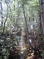
 Tamagawa Aqueduct in Hamura 35°44′57.84″N 139°18′59.49″E / 35.7494000°N 139.3165250°E / 35.7494000; 139.3165250
 -
 Tamagawa Aqueduct in Tachikawa 35°43′41.74″N 139°25′48.59″E / 35.7282611°N 139.4301639°E / 35.7282611; 139.4301639
 -
 Tamagawa Aqueduct in Koganei 35°42′45.46″N 139°31′05.36″E / 35.7126278°N 139.5181556°E / 35.7126278; 139.5181556
 -
 Tamagawa Aqueduct near Daitabashi Station, Setagaya 35°40′15.96″N 139°39′36.21″E / 35.6711000°N 139.6600583°E / 35.6711000; 139.6600583


References
- ^ Murdoch, James (1903). Longford, Joseph H. (ed.). A History of Japan. Vol. 3 (1996 ed.). Routledge. p. 81. ISBN 0-415-15417-0.
- ^ 玉川上水の歴史 [The History of Tamagawa Jōsui] (in Japanese). Bureau of Waterworks, Tokyo Metropolitan Government. Archived from the original on August 2, 2014. Retrieved August 22, 2014.
- ^ Murdoch, James (1903). Longford, Joseph H. (ed.). A History of Japan. Vol. 3 (1996 ed.). Routledge. p. 82. ISBN 0-415-15417-0.
- ^ 太宰治略年譜 [Osamu Dazai, short timeline] (in Japanese). Mitaka City. Retrieved August 22, 2014.
External links
Tamagawa Jōsui page on the Bureau of Waterworks, Tokyo Metropolitan Government
Map all coordinates using OpenStreetMap
Download coordinates as:
- KML
- GPX (all coordinates)
- GPX (primary coordinates)
- GPX (secondary coordinates)
Wikimedia Commons has media related to Tamagawa_waterworks.
Authority control databases | |
|---|---|
| International |
|
| National |
|


