Sulphur River
River in Texas and Arkansas in the United States
33°23′36″N 95°21′20″W / 33.3933333°N 95.3555556°W / 33.3933333; -95.3555556[1] • location
• coordinates
• elevation
The Sulphur River is a 175-mile-long (282 km)[2] river in northeast Texas and southwest Arkansas in the United States.
Geography
The Sulphur River begins at the confluence of its north and south forks forming (following earlier meanders) the northern and southern boundaries of, and meeting at the eastern end of, Delta County (Texas).[3] This is about 4.7 miles (7.6 km) northeast of the town of Sulphur Bluff, 95 miles (153 km) northeast of Dallas, and 16 miles (26 km) downstream (air miles) along the south fork from the Cooper Lake dam.
The river flows generally eastward through several Texas counties. Tributaries include Shawnee Creek and Brevelle Lake. The river provides most of the water for Wright Patman Lake, on the border between Bowie and Cass counties. Below Wright Patman Dam, the river continues its generally eastward flow to the Arkansas state line. The river flows southeastward through Miller County in southwestern Arkansas for 15 miles (24 km) until it joins the southbound Red River east of Doddridge, a few miles north of the Louisiana border.
Recreation
The Sulphur River provides numerous opportunities for fishing, boating, and other activities.
Above Wright Patman Lake, the river has enough water for recreation most of the time. The flow is slow, and the river is murky, largely due to channelization upstream. Below Wright Patman Dam, the river flow depends on the amount of water being released from the dam; however, water quality is usually good.
Wright Patman Lake provides additional opportunities for camping, boating, swimming, and fishing.[4]
-
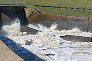 The spillway at Lake Wright Patman during the flood of 2015-2016. After this the Sulphur river flows into Miller County, Arkansas.
 -
 The control center for the Lake Wright Patman dam gates. After this the Sulphur river flows into Miller County, Arkansas.
 -
 This is a brass survey marker for the Lake Wright Patman Dam installed in 1981 by the U.S. Army Corps of Engineers


See also
 Rivers portal
 Arkansas portal
 Texas portal


- List of rivers of Texas
- Sulphur Springs, Texas
- Days Creek
- Brevelle Lake
References
- ^ a b c U.S. Geological Survey Geographic Names Information System: Sulphur River
- ^ "The National Map". U.S. Geological Survey. Retrieved March 8, 2011.
- ^ National Map (Map). USGS. Retrieved 15 Jan 2022.
- ^ "Wright Patman Dam and Lake". US Army Corps of Engineers. Retrieved 15 Jan 2022.
External links
Wikimedia Commons has media related to Sulphur River.
- Sulphur River Basin Authority
- Texas Parks and Wildlife Department: An Analysis of Texas Waterways
- Sulphur River from the Handbook of Texas Online
- v
- t
- e
 Waters of Texas
of the Gulf of Mexico
- Alazan Bay
- Aransas Bay
- Baffin Bay
- Carancahua Bay
- Christmas Bay
- Copano Bay
- Corpus Christi Bay
- Dickinson Bay
- East Bay
- East Matagorda Bay
- Espiritu Santo Bay
- Galveston Bay
- Guadalupe Bay
- Laguna Madre
- Lavaca Bay
- Matagorda Bay
- Nueces Bay
- Oso Bay
- Redfish Bay
- Sabine Lake
- San Antonio Bay
- South Bay
- St. Charles Bay
- Tres Palacios Bay
- Trinity Bay
- West Bay
- Acequia Madre de Valero
- American Canal
- Aransas Pass
- Bolivar Roads
- Brazos Santiago Pass
- Cedar Bayou
- Franklin Canal
- Gulf Intracoastal Waterway
- Houston Ship Channel
- Matagorda Ship Channel
- Pass Cavallo
- Port Mansfield Channel
- Riverside Canal
- Sabine Pass
- Sabine–Neches Waterway
- San Luis Pass
- Amistad Reservoir
- Caddo Lake
- Canyon Lake
- Cedar Creek Reservoir
- Choke Canyon Reservoir
- Falcon International Reservoir
- Inks Lake
- Lady Bird Lake
- Lavon Lake
- Lake Austin
- Lake Bardwell
- Lake Buchanan
- Lake Conroe
- Lake Corpus Christi
- Lake Ray Hubbard
- Lake Ray Roberts
- Lake LBJ
- Lake Livingston
- Lake Marble Falls
- Lake Meredith
- Lake Tawakoni
- Lake Texoma
- Lake Travis
- Lewisville Lake
- Richland-Chambers Reservoir
- Sam Rayburn Reservoir
- Toledo Bend Reservoir
- Angelina River
- Blanco River
- Bosque River
- Brazos River
- Buffalo Bayou
- Colorado River
- Concho River
- Canadian River
- Guadalupe River
- James River
- Lampasas River
- Lavaca River
- Leon River
- Little River
- Llano River
- Navidad River
- Neches River
- Nolan River
- Nueces River
- Paluxy River
- Pease River
- Pedernales River
- Prairie Dog Town Fork Red River
- Red River
- Rio Grande
- Devils River
- Pecos River
- Sabine River
- San Antonio River
- San Bernard River
- San Gabriel River
- San Jacinto River
- San Marcos River
- San Saba River
- Sulphur River
- Trinity River
- Wichita River
- White River
- Big Cypress Bayou
- Cow Bayou
- Ottine wetlands
- Rincon Bayou
- Rio Grande Valley
| Authority control databases: National |
|
|---|


