Stuttgart-North
Borough of Stuttgart in Baden-Württemberg, Germany
Stuttgart-North Stuttgart-Nord | |
|---|---|
Borough of Stuttgart | |
 Bismarckturm | |
 Coat of arms | |
Location within Stuttgart 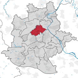 | |
48°47′50″N 9°10′37″E / 48.79722°N 9.17694°E / 48.79722; 9.17694 | |
| Country | Germany |
| State | Baden-Württemberg |
| Admin. region | Stuttgart |
| District | Stuttgart |
| City | Stuttgart |
| Founded | 10th Century |
| Government | |
| • Borough mayor | Sabine Mezger |
| Area | |
| • Total | 6.815 km2 (2.631 sq mi) |
| Highest elevation | 409 m (1,342 ft) |
| Lowest elevation | 210 m (690 ft) |
| Population (2020-12-31)[1] | |
| • Total | 27,275 |
| • Density | 4,000/km2 (10,000/sq mi) |
| Time zone | UTC+01:00 (CET) |
| • Summer (DST) | UTC+02:00 (CEST) |
| Postal codes | 70174, 70191, 70192 |
| Dialling codes | 0711 |
| Vehicle registration | S |
| Website | www.stuttgart.de |
Stuttgart-Nord is an inner city borough in the north of Stuttgart.
Geography
Stuttgart-Nord extends from the Doggenburg to the highest point, the Gähkopf (409 m above sea level) to the Bismarckturm, on the Killesberg and the Pragsattel to Rosenstein Park and the Pragfriedhof. The Pragsattel located at the lowest point of a ridge from Killesberg to Burgholzhof.
One finds in Stuttgart-Nord numerous good residential areas and viewpoints on the Stuttgart city center. Noteworthy streets are: Am Bismarckturm, Am Gähkopf, Caesar Flaischlen Street, Eduard-Pfeiffer-Straße, Feuerbacher Heide, Lenzhalde, Robert-Bosch-Straße and Schottstraße.
History
Stuttgart-North was created when Stuttgart was divided into districts in 1956. The western boundary of this new district extended from the Doggenburg to Weißenhof and Killesberg. When the districts were reorganised on January 1, 2001, Stuttgart-North was split into 11 subdistricts.
References
- ^ "Aktuelle Einwohnerzahlen nach Stadtbezirken und Stadtteilen". Landeshauptstadt Stuttgart. Retrieved 22 September 2021.
- v
- t
- e
Districts of Stuttgart
- Stuttgart-Center
- Stuttgart-North
- Stuttgart-East
- Stuttgart-South
- Stuttgart-West

- Bad Cannstatt
- Birkach
- Botnang
- Degerloch
- Feuerbach
- Hedelfingen
- Möhringen
- Mühlhausen
- Münster am Neckar
- Obertürkheim
- Plieningen
- Sillenbuch
- Stammheim
- Untertürkheim
- Vaihingen
- Wangen
- Weilimdorf
- Zuffenhausen
| Authority control databases: National |
|
|---|


