Smeltertown, Texas
Former neighborhood of El Paso, Texas

Smeltertown was a residential community in El Paso County, Texas,[1] housing the workers of the ASARCO smelter and their families, between El Paso and the Texas borders with Mexico and New Mexico.
With only one small neighborhood, now known as the La Calavera Historical Neighborhood,[2] remaining since the Smelter's closure, Smeltertown is sometimes referred to as a ghost town.[3]
The Smeltertown community was served by the San Jose church, and by the Jones School of the El Paso Independent School District.
-
 Abandoned baja part of Smeltertown is left of center here, with the American Dam Headquarters (white building) in it, near the American Dam on the Rio Grande, in this aerial view from over downtown El Paso. La Calavera is at upper right.
 -
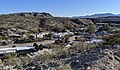 Looking down into La Calavera Historic Neighborhood from beside Executive Center Blvd.
 -
 Smeltertown cemetery with ASARCO smelter chimneys in the background, still operating, in 1972.
 -
 The new (in 2019) Border West Expressway single-point urban interchange – El Paso's first SPUI – is at Executive Center Blvd., which parallels San Marcos Drive of the La Calavera Historic Neighborhood of Smeltertown. The Smeltertown Cemetery is visible at the bottom by the expressway.


See also
References
- ^ "Smeltertown". Geographic Names Information System. United States Geological Survey, United States Department of the Interior. Retrieved March 28, 2020.
- ^ "Details for Smeltertown (Atlas Number 5141013137) Historical Marker". Texas Historic Sites Atlas. Retrieved December 29, 2019.
- ^ "Smelter Town – a personal look at a ghost town firmly embedded in El Paso history". Borderzine. Retrieved December 29, 2019.
- v
- t
- e
31°47′00″N 106°31′36″W / 31.78333°N 106.52667°W / 31.78333; -106.52667


