Sils im Domleschg
Municipality in Graubünden, Switzerland

Coat of arms
Location of Sils im Domleschg

46°42′N 9°27′E / 46.700°N 9.450°E / 46.700; 9.450
(31 December 2018)[2]
7411
SFSO statistics
Sils im Domleschg (Romansh: Seglias) is a municipality in the Viamala Region in the Swiss canton of Graubünden.
History
Sils im Domleschg is first mentioned in 1149 as de Sillas.[3]
Geography


Sils im Domleschg has an area, (as of the 2004/09 survey) of 9.28 km2 (3.58 sq mi).[4] Of this area, about 14.6% is used for agricultural purposes, while 70.4% is forested. Of the rest of the land, 8.2% is settled (buildings or roads) and 6.9% is unproductive land.
In the 2004/09 survey a total of 35 ha (86 acres) or about 3.8% of the total area was covered with buildings, an increase of 4 ha (9.9 acres) over the 1984/85 amount. Of the agricultural land, 5 ha (12 acres) is used for orchards and vineyards, 78 ha (190 acres) is fields and grasslands and 64 ha (160 acres) consists of alpine grazing areas. Since 1984/85 the amount of agricultural land has decreased by 7 ha (17 acres). Over the same time period the amount of forested land has increased by 11 ha (27 acres). Rivers and lakes cover 11 ha (27 acres) in the municipality.[5][6]
Before 2017, the municipality was located in the Domleschg sub-district, of the Hinterrhein district, after 2017 it was part of the Viamala Region.[7] It is a linear village between the Albula and Hinterrhein rivers. It consists of the village of Sils im Domleschg and the hamlets of Freihof, Campi and Albula.
Demographics
Sils im Domleschg has a population (as of December 2020[update]) of 971.[8] As of 2014[update], 16.3% of the population are resident foreign nationals. In 2015 a small minority (50 or 5.4% of the population) was born in Portugal.[9] Over the last 4 years (2010-2014) the population has changed at a rate of 5.60%. The birth rate in the municipality, in 2014, was 11.0, while the death rate was 5.5 per thousand residents.[6]
As of 2014[update], children and teenagers (0–19 years old) make up 21.5% of the population, while adults (20–64 years old) are 58.1% and seniors (over 64 years old) make up 20.3%.[6] In 2015 there were 365 single residents, 444 people who were married or in a civil partnership, 50 widows or widowers and 68 divorced residents.[10]
In 2014 there were 387 private households in Sils im Domleschg with an average household size of 2.36 persons. Of the 214 inhabited buildings in the municipality, in 2000, about 50.0% were single family homes and 32.7% were multiple family buildings. Additionally, about 28.0% of the buildings were built before 1919, while 15.9% were built between 1991 and 2000.[11] In 2013 the rate of construction of new housing units per 1000 residents was 7.82. The vacancy rate for the municipality, in 2015[update], was 2.37%.[6]
The historical population is given in the following table:[3][12]
| year | population |
|---|---|
| 1803 | 277 |
| 1850 | 295 |
| 1900 | 621 |
| 1910 | 541 |
| 1950 | 590 |
| 1960 | 737 |
| 1970 | 762 |
| 1980 | 826 |
| 1990 | 794 |
| 2000 | 880 |
Languages
Most of the population (as of 2000[update]) speaks German (86.8%), with Serbo-Croatian being second most common (3.3%) and Italian being third (2.8%).[13]
| Languages | Census 1980 | Census 1990 | Census 2000 | |||
|---|---|---|---|---|---|---|
| Number | Percent | Number | Percent | Number | Percent | |
| German | 612 | 74.09% | 646 | 81.36% | 764 | 86.82% |
| Romansh | 56 | 6.78% | 34 | 4.28% | 14 | 1.59% |
| Italian | 104 | 12.59% | 60 | 7.56% | 25 | 2.84% |
| Population | 826 | 100% | 794 | 100% | 880 | 100% |
Heritage sites of national significance
Ehrenfels Castle, Carschenna (pre-historic petroglyphs), the ruins of Hohenrätien Castle and the ruins of Campell or Campi Castle are listed as Swiss heritage sites of national significance.[14]
-
 Carschenna petroglyphs
 -
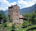 Burg Ehrenfels
 -
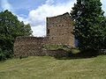 Ruins of Hohenrätien
 -
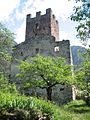 Ruine Campi (or Campell)


Politics
In the 2015 federal election the most popular party was the SVP with 35.8% of the vote. The next three most popular parties were the BDP (20.1%), the SP (15.1%) and the FDP (12.7%). In the federal election, a total of 287 votes were cast, and the voter turnout was 45.9%. The 2015 election saw a large change in the voting when compared to 2011. The percentage of the vote received by the SVP increased from 27.8% in 2011 to 35.8% in 2015, while the percentage that the BDP dropped from 31.1% to 20.1%.[15]
In the 2007 federal election the most popular party was the SVP which received 43.4% of the vote. The next three most popular parties were the SPS (27.4%), the FDP (19.7%) and the CVP (8.1%).[13]
Education
In Sils im Domleschg about 73.3% of the population (between age 25-64) have completed either non-mandatory upper secondary education or additional higher education (either university or a Fachhochschule).[13]
Economy
Sils im Domleschg is an industrial-tertiary municipality, a municipality where agriculture and manufacturing play a minor role in the economy.[16]
As of 2014[update], there were a total of 287 people employed in the municipality. Of these, a total of 14 people worked in 6 businesses in the primary economic sector. The secondary sector employed 160 workers in 21 separate businesses. A minority (25.6%) of the secondary sector employees worked in very small businesses. There were 5 small businesses with a total of 119 employees. Finally, the tertiary sector provided 113 jobs in 42 businesses.[17] In 2014 a total of 7.8% of the population received social assistance.[6]
Religion

From the 2000 census[update], 700 or 33.0% are Roman Catholic, while 1,176 or 55.4% belonged to the Swiss Reformed Church. Of the rest of the population, there are 43 individuals (or about 2.03% of the population) who belong to the Orthodox Church, and there are 13 individuals (or about 0.61% of the population) who belong to another Christian church. There are 21 (or about 0.99% of the population) who are Muslim. There was 1 individual (or about 0.05% of the population) who belonged to another church (not listed on the census), 97 (or about 4.57% of the population) who belong to no church, are agnostic or atheist, and 71 individuals (or about 3.35% of the population) who did not answer the question.[18]
References
- ^ a b "Arealstatistik Standard - Gemeinden nach 4 Hauptbereichen". Federal Statistical Office. Retrieved 13 January 2019.
- ^ "Ständige Wohnbevölkerung nach Staatsangehörigkeitskategorie Geschlecht und Gemeinde; Provisorische Jahresergebnisse; 2018". Federal Statistical Office. 9 April 2019. Retrieved 11 April 2019.
- ^ a b Sils im Domleschg in German, French and Italian in the online Historical Dictionary of Switzerland.
- ^ Arealstatistik Standard - Gemeindedaten nach 4 Hauptbereichen
- ^ "Arealstatistik Land Use - Gemeinden nach 10 Klassen". www.landuse-stat.admin.ch. Swiss Federal Statistical Office. 24 November 2016. Retrieved 27 December 2016.
- ^ a b c d e Swiss Federal Statistical Office - Regional portraits accessed 27 October 2016
- ^ Swiss Federal Statistical Office - Amtliches Gemeindeverzeichnis der Schweiz - Mutationsmeldungen 2016 accessed 16 February 2017
- ^ "Ständige und nichtständige Wohnbevölkerung nach institutionellen Gliederungen, Geburtsort und Staatsangehörigkeit". bfs.admin.ch (in German). Swiss Federal Statistical Office - STAT-TAB. 31 December 2020. Retrieved 21 September 2021.
- ^ Federal Statistical Office - Ständige und nichtständige Wohnbevölkerung nach institutionellen Gliederungen, Geburtsort und Staatsangehörigkeit (Land) accessed 31 October 2016
- ^ Swiss Federal Statistical Office - Ständige und nichtständige Wohnbevölkerung nach institutionellen Gliederungen, Geschlecht, Zivilstand und Geburtsort (in German) accessed 8 September 2016
- ^ Swiss Federal Statistical Office STAT-TAB - Thema 09 - Bau- und Wohnungswesen (in German) accessed 5 May 2016
- ^ Swiss Federal Statistical Office STAT-TAB Bevölkerungsentwicklung nach institutionellen Gliederungen, 1850-2000 (in German) accessed 27 April 2016
- ^ a b c Swiss Federal Statistical Office accessed 5 October 2009
- ^ Swiss inventory of cultural property of national and regional significance Archived 2009-05-01 at the Wayback Machine 21.11.2008 version, (in German) accessed 05-Oct-2009
- ^ Swiss Federal Statistical Office - Nationalratswahlen 2015: Stärke der Parteien und Wahlbeteiligung nach Gemeinden Archived 2016-08-02 at the Wayback Machine (in German) accessed 18 July 2016
- ^ "Die Raumgliederungen der Schweiz 2016" (in German, French, Italian, and English). Neuchâtel, Switzerland: Swiss Federal Statistical Office. 17 February 2016. Retrieved 14 December 2016.
- ^ Federal Statistical Office -Arbeitsstätten und Beschäftigte nach Gemeinde, Wirtschaftssektor und Grössenklasse accessed 31 October 2016
- ^ Graubunden Population Statistics Archived 2009-08-27 at the Wayback Machine (in German) accessed 21 September 2009
Wikimedia Commons has media related to Sils im Domleschg.
External links
- Official Web site
- v
- t
- e

Authority control databases | |
|---|---|
| International |
|
| National |
|
| Other |
|


