Siemensstadt
Quarter of Berlin in Germany
Location of Siemensstadt in Spandau district and Berlin

52°32′26″N 13°15′47″E / 52.54056°N 13.26306°E / 52.54056; 13.26306
(2020-12-31)[1]
(nr. 0503) 13629
Siemensstadt (German: [ˈziːmənsˌʃtat] ⓘ) is a locality (Ortsteil) of Berlin in the district (Bezirk) of Spandau.
History
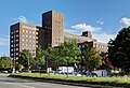
The locality emerged when the company Siemens & Halske (S & H), one of the predecessors of today's Siemens, bought land in the area, in order to expand production of S & H and their subsidiary Siemens-Schuckertwerke (SSW) as well. On the initiative of Georg Wilhelm von Siemens, S & H started to build new factories in 1899. Soon also residential buildings were erected. The locality was incorporated into Berlin on 1 October 1920 by the Greater Berlin Act.
During World War II, Siemensstadt was the location of a subcamp of the Sachsenhausen concentration camp for men and women, mostly Hungarian Jews, but also Bulgarians, French, Italians, Yugoslavs, Dutch, Poles, Czechoslovaks, Russians and Ukrainians.[2]
Geography
Siemensstadt is situated on the eastern side of the Spandau district. It borders Spandau (locality), Haselhorst, Tegel (in Reinickendorf), Charlottenburg-Nord and Westend (both in Charlottenburg-Wilmersdorf). The Großsiedlung Siemensstadt is situated close to Siemensstadt but in Charlottenburg-Nord.
Transport
Siemensstadt is served by the Berliner U-Bahn line U7 at the stations of Paulsternstrasse, Rohrdamm and Siemensdamm.
Images
-
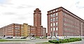 Siemens-Tower
 -
 Wernerwerk (Werner's Factory)
 -
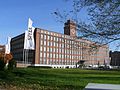 Wernerwerk II
 -
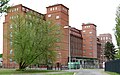 Wernerwerk XV
 -
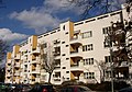
 Rapsstrasse, northern part
 -
 Rapsstrasse
 -
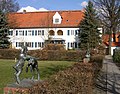
 Christophorus Church
 -
 Rohrdamm
 -
 Genoveva-Fountain
 -
 Rieppelstrasse
 -
 Rieppel- Ecke Dihlmannstrasse
 -
 Maeckeritzstrasse


See also
References
- ^ "Einwohnerinnen und Einwohner im Land Berlin am 31. Dezember 2020" (PDF). Amt für Statistik Berlin-Brandenburg. February 2021.
- ^ Megargee, Geoffrey P. (2009). The United States Holocaust Memorial Museum Encyclopedia of Camps and Ghettos 1933–1945. Volume I. Indiana University Press, United States Holocaust Memorial Museum. p. 1284. ISBN 978-0-253-35328-3.
External links
![]() Media related to Siemensstadt at Wikimedia Commons
Media related to Siemensstadt at Wikimedia Commons
- (in German) Siemensstadt page on www.berlin.de
- v
- t
- e
 Charlottenburg-Wilmersdorf (4)
- Charlottenburg
- Charlottenburg-Nord
- Grunewald
- Halensee
- Schmargendorf
- Westend
- Wilmersdorf
 Friedrichshain-Kreuzberg (2)
 Lichtenberg (11)
- Alt-Hohenschönhausen
- Falkenberg
- Fennpfuhl
- Friedrichsfelde
- Karlshorst
- Lichtenberg
- Malchow
- Neu-Hohenschönhausen
- Rummelsburg
- Wartenberg
 Marzahn-Hellersdorf (10)
- Biesdorf
- Hellersdorf
- Kaulsdorf
- Mahlsdorf
- Marzahn
 Mitte (1)
- Gesundbrunnen
- Hansaviertel
- Mitte
- Moabit
- Tiergarten
- Wedding
 Neukölln (8)
- Britz
- Buckow
- Gropiusstadt
- Neukölln
- Rudow
 Pankow (3)
- Blankenburg
- Blankenfelde
- Buch
- Französisch Buchholz
- Heinersdorf
- Karow
- Niederschönhausen
- Pankow
- Prenzlauer Berg
- Rosenthal
- Stadtrandsiedlung Malchow
- Weißensee
- Wilhelmsruh
 Reinickendorf (12)
- Borsigwalde
- Frohnau
- Heiligensee
- Hermsdorf
- Konradshöhe
- Lübars
- Märkisches Viertel
- Reinickendorf
- Tegel
- Waidmannslust
- Wittenau
 Spandau (5)
- Falkenhagener Feld
- Gatow
- Hakenfelde
- Haselhorst
- Kladow
- Siemensstadt
- Spandau
- Staaken
- Wilhelmstadt
 Steglitz-Zehlendorf (6)
- Dahlem
- Lankwitz
- Lichterfelde
- Nikolassee
- Schlachtensee
- Steglitz
- Wannsee
- Zehlendorf
 Tempelhof-Schöneberg (7)
 Treptow-Köpenick (9)
- Districts
- Localities
- Zones
- Greater Berlin Act
- Former boroughs

Authority control databases | |
|---|---|
| International |
|
| National |
|


