Riethoven
Village in North Brabant, Netherlands

Flag
Coat of arms
51°21′13″N 5°23′11″E / 51.35361°N 5.38639°E / 51.35361; 5.38639
 Netherlands
 North Brabant
 Bergeijk
 (2021)[1]
5561[1]
Riethoven (Dutch pronunciation: [ˈrithoːvə(n)]) is a village in the Dutch province of North Brabant. It is located in the municipality of Bergeijk, about 15 km (9.3 mi) southwest of Eindhoven. The adjacent township of Walik is in general considered to be a part of Riethoven. Riethoven was originally called Rijthoven, but with time it changed into Riethoven. In Dutch The name means: farms at the Rijt, the Rijt being a river near the municipality.
Riethoven was a separate municipality until 1997, when it became part of Bergeijk.[3]
The spoken language is Kempenlands (an East Brabantian dialect, which is very similar to Standard Dutch).[4]
Notable people
- Martin Rythovius (1511), the first Bishop of Ypres
- Henk van Gerven (1955), politician
- Wilbert Das (1963), Fashion designer
Gallery
-
 Bar in Riethoven
 -
 St Willibrordus Church
 -
 Bandstand
 -
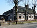
 Farm in Riethoven


References
- ^ a b c "Kerncijfers wijken en buurten 2021". Central Bureau of Statistics. Retrieved 15 April 2022.
- ^ "Postcodetool for 5561AA". Actueel Hoogtebestand Nederland (in Dutch). Het Waterschapshuis. Retrieved 15 April 2022.
- ^ Ad van der Meer and Onno Boonstra, Repertorium van Nederlandse gemeenten, KNAW, 2011.
- ^ Jos & Cor Swanenberg: Taal in stad en land: Oost-Brabants, ISBN 9012090105
Wikimedia Commons has media related to Riethoven.
- v
- t
- e
Populated places in the municipality of Bergeijk
- Loo [nl]
- Luyksgestel
- Riethoven
- Weebosch [nl]
- Westerhoven
- Boshoven
- Boscheind
- Braambosch
- Broekhoven
- De Aa
- De Rund
- Eind
- Heiereind
- Hooge Berkt
- Lage Berkt
- Loveren
- Muggenhool
- Rijt
- Sengelsbroek
- Spaanrijt
- Voort
- Walik
- Witrijt
| Authority control databases |
|
|---|
51°21′N 5°23′E / 51.350°N 5.383°E / 51.350; 5.383
 | This North Brabant location article is a stub. You can help Wikipedia by expanding it. |
- v
- t
- e


