Nennig
Village in Saarland, Germany
Ortsteil of Perl in Saarland, Germany

Coat of arms
Location of Nennig

49°32′00″N 06°23′00″E / 49.53333°N 6.38333°E / 49.53333; 6.38333
(2010)
66706
Nennig is a village in the Saarland, Germany, part of the municipality of Perl. It is situated on the river Moselle, opposite Remich, Luxembourg.
Overview
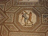
Nennig is known for a Roman villa containing well-preserved mosaics that were excavated in the 19th century. The village was a condominium of the Trier bishopric, Lorraine (the Kingdom of France from 1766) and Luxembourg until its annexation by Revolutionary France in 1794. During the Second World War Nennig was almost completely destroyed as the village changed hands several times in late-1944 and early-1945.
Photogallery
-
 Schloss Berg
 -
 Roman villa


-
 Mosaic in Roman villa
 -
 A retiarius gladiator stabs his secutor opponent (Mosaic of Nennig)


See also
External links
![]() Media related to Nennig at Wikimedia Commons
Media related to Nennig at Wikimedia Commons
- (in German) Nennig official website
Authority control databases | |
|---|---|
| International |
|
| National |
|


