Naval Air Station Wildwood
Airport in Lower Township, New Jersey


Naval Air Station Wildwood

Naval Air Station Wildwood

Naval Air Station Wildwood
Naval Air Station Wildwood was a United States Navy airport located in Lower Township, Cape May County, New Jersey, United States,[1] about 4 miles (6.4 km) northwest of the central business district of Wildwood, a city in the same county.[2] Former Hangar #1 now contains the Naval Air Station Wildwood Aviation Museum, whose collection focuses on World War II.
History
The airport started in 1941 as NAS Rio Grande, named for its location near Rio Grande, New Jersey. Due to confusion with Rio Grande, Texas, the name was changed to NAS Wildwood in 1943, in relation to Wildwood, New Jersey. Following the end of World War II, Naval Air Station Wildwood was deemed excess to U.S. Navy requirements. It was subsequently deeded to the local government for transition to a civilian airport which is still in operation today as Cape May Airport. The surviving portions of the historic airfield, including its runways and taxiways, were listed on the National Register of Historic Places in 2015.[3]
Historic district
United States historic place
Naval Air Station Wildwood Historic District | |
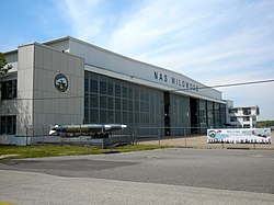 Hangar No. 1 | |
| Area | 11 acres (4.5 ha) |
|---|---|
| NRHP reference No. | 13000945[3] |
| NJRHP No. | 4904[4] |
| Significant dates | |
| Added to NRHP | July 28, 2015 |
| Designated NJRHP | August 28, 2013 |
The Naval Air Station Wildwood Historic District is an 11-acre (4.5 ha) historic district encompassing the airfield, bounded by Forrestal and Monterre Roads, and the runways and taxiways to the north and east. The district includes two contributing buildings and one contributing structure. It was added for its significance in military history from 1942 to 1945.[5]
See also
References
- ^ "Zoning Map" (PDF). Lower Township. Retrieved 2020-09-23. - The zoning map shows the airport in the township boundaries.
- ^ FAA Airport Form 5010 for WWD PDF, effective 2008-06-05
- ^ a b "National Register Information System – (#13000945)". National Register of Historic Places. National Park Service. November 2, 2013.
- ^ "New Jersey and National Registers of Historic Places – Cape May County" (PDF). New Jersey Department of Environmental Protection – Historic Preservation Office. December 22, 2021. p. 5.
- ^ Berkey, Joan (June 2015). "National Register of Historic Places Inventory/Nomination: Naval Air Station Wildwood Historic District". National Park Service. With accompanying 15 photos.
- v
- t
- e
- Cold Spring
- Diamond Beach
- Erma
- Miami Beach
- North Cape May (independent until 1945)
- Rio Grande (part)
- South Cape May (independent until 1945)
- Villas
- Battery 223
- Cape May–Lewes Ferry Terminal
- Cape May Airport
- Cape May Point State Park (parts)
- Cape May Winery & Vineyard
- Owen Coachman House
- Cold Spring Grange Hall
- Cold Spring Presbyterian Church
- Fire Control Tower No. 23
- Fishing Creek Schoolhouse
- Hawk Haven Vineyard & Winery
- George Hildreth House
- Jonathan Pyne House
- Rio Grande station
- Sunset Beach
- Turdo Vineyards & Winery
- Historic Cold Spring Village
- Naval Air Station Wildwood
This list is incomplete.
Some areas considered to be Rio Grande are in Lower Township though the census-designated place (CDP) itself is in Middle Township.
Cape Christian Academy formerly had campuses in Lower Township.
St. Raymond Catholic School merged into Our Lady Star of the Sea in Cape May which merged into what became Wildwood Catholic Academy.

Authority control databases | |
|---|---|
| International |
|
| National |
|


