National Register of Historic Places listings in Prince George's County, Maryland
This is a list of the National Register of Historic Places listings in Prince George's County, Maryland.
This is intended to be a complete list of the properties and districts on the National Register of Historic Places in Prince George's County, Maryland, United States. Latitude and longitude coordinates are provided for many National Register properties and districts; these locations may be seen together in a map.[1]
There are 106 properties and districts listed on the National Register in the county, including 6 National Historic Landmarks.
Map all coordinates using OpenStreetMap
Download coordinates as:
- KML
- GPX (all coordinates)
- GPX (primary coordinates)
- GPX (secondary coordinates)
| Allegany - Anne Arundel - Baltimore (city) - Baltimore County - Calvert - Caroline - Carroll - Cecil - Charles - Dorchester - Frederick - Garrett - Harford - Howard - Kent - Montgomery - Prince George's - Queen Anne's - Somerset - St. Mary's - Talbot - Washington - Wicomico - Worcester |
This National Park Service list is complete through NPS recent listings posted May 10, 2024.[2]
Current listings
| [3] | Name on the Register[4] | Image | Date listed[5] | Location | City or town | Description |
|---|---|---|---|---|---|---|
| 1 | Abraham Hall |  | March 14, 2005 (#05000146) | 7612 Old Muirkirk Rd. 39°03′40″N 76°52′24″W / 39.061111°N 76.873333°W / 39.061111; -76.873333 (Abraham Hall) | Beltsville | Former lodge hall and school constructed in 1889; part of the Multiple Property Submission for the African-American Historic Resources of Prince George's County, Maryland. |
| 2 | Accokeek Creek Site |  | October 15, 1966 (#66000909) | Address Restricted | Accokeek | Site of a palisaded village that was occupied from ca. A.D. 1300 to ca. 1630. |
| 3 | Ammendale Normal Institute | 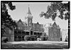 | April 14, 1975 (#75002081) | Junction of Ammendale Rd. and U.S. Route 1 39°03′08″N 76°54′05″W / 39.052222°N 76.901389°W / 39.052222; -76.901389 (Ammendale Normal Institute) | Beltsville | Former school and novitiate operated by the Congregation of Christian Brothers. |
| 4 | Ash Hill | 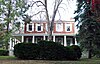 | September 16, 1977 (#77001523) | 3308 Rosemary Lane 38°58′49″N 76°57′34″W / 38.980278°N 76.959444°W / 38.980278; -76.959444 (Ash Hill) | Hyattsville | Two-story brick dwelling erected ca. 1840. |
| 5 | Ashland |  | September 15, 1994 (#94001155) | 16109 Marlboro Pike 38°49′01″N 76°43′44″W / 38.816944°N 76.728889°W / 38.816944; -76.728889 (Ashland) | Upper Marlboro | Victorian Italianate style home built in 1866-1867. |
| 6 | Avondale Mill |  | September 20, 1979 (#79003267) | 21 Avondale St. 39°06′25″N 76°50′46″W / 39.106944°N 76.846111°W / 39.106944; -76.846111 (Avondale Mill) | Laurel | Site of former grist mill complex. |
| 7 | Baltimore-Washington Parkway |  | May 9, 1991 (#91000532) | DC border near the Anacostia R., northeast to just below Jessup Rd. (Maryland Route 175) 39°00′56″N 76°51′46″W / 39.015556°N 76.862778°W / 39.015556; -76.862778 (Baltimore-Washington Parkway) | Cheverly to Baltimore | Part of the Multiple Property Submission for the Parkways of the National Capital Region. |
| 8 | Beall's Pleasure | 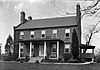 | May 4, 1979 (#79003169) | Southeast of Landover at 7250 Old Landover Rd. 38°55′51″N 76°53′10″W / 38.930833°N 76.886111°W / 38.930833; -76.886111 (Beall's Pleasure) | Landover | Federal brick house constructed ca. 1795. |
| 9 | Belair |  | September 16, 1977 (#77001520) | Tulip Grove and Belair Drives 38°57′57″N 76°44′50″W / 38.965833°N 76.747222°W / 38.965833; -76.747222 (Belair) | Bowie | Georgian plantation home of the Provincial Governor of Maryland, Samuel Ogle built in about 1745; now museum. |
| 10 | Belair Stables | 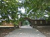 | May 8, 1973 (#73002163) | Belair Dr. 38°57′59″N 76°44′37″W / 38.966389°N 76.743611°W / 38.966389; -76.743611 (Belair Stables) | Bowie | U-shaped sandstone stable was built in 1907; now museum. |
| 11 | Bellefields | 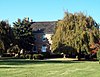 | September 10, 1971 (#71001027) | 13104 Duley Station Road 38°44′45″N 76°46′38″W / 38.745833°N 76.777222°W / 38.745833; -76.777222 (Bellefields) | Croom | Georgian style manor house constructed about 1720. |
| 12 | Bellevue |  | August 21, 1986 (#86001738) | 315 Farmhouse Road (formerly 200 Manning Road East) 38°39′41″N 77°00′05″W / 38.661389°N 77.001389°W / 38.661389; -77.001389 (Bellevue) | Accokeek | Greek Revival style home constructed about 1840. |
| 13 | Bostwick |  | August 19, 1975 (#75002082) | 3901 48th St. 38°56′16″N 76°56′05″W / 38.937778°N 76.934722°W / 38.937778; -76.934722 (Bostwick) | Bladensburg | Brick dwelling built in 1746; home of Benjamin Stoddert, first Secretary of the Navy. |
| 14 | Bowie Railroad Buildings |  | November 4, 1998 (#98001261) | 8614 Chestnut Ave. 39°00′26″N 76°46′46″W / 39.007222°N 76.779444°W / 39.007222; -76.779444 (Bowie Railroad Buildings) | Bowie | Railroad depot complex for the Pennsylvania Railroad at the junction of the Washington (Amtrak/MARC Train) and the Pope's Creek branches; now Huntington Railroad Museum. |
| 15 | Bowieville |  | March 14, 1973 (#73002167) | 522 Church Rd., S. 38°53′07″N 76°45′08″W / 38.885278°N 76.752222°W / 38.885278; -76.752222 (Bowieville) | Upper Marlboro | Federal style plantation house built 1819-20. |
| 16 | Bowling Heights | 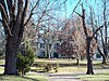 | November 30, 1982 (#82001599) | 3610 Old Crain Highway 38°50′22″N 76°43′31″W / 38.839444°N 76.725278°W / 38.839444; -76.725278 (Bowling Heights) | Upper Marlboro | High Victorian Gothic style dwelling constructed in 1877. |
| 17 | Broad Creek Historic District | 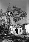 | December 8, 2011 (#11000881) | Bounded by Oxon Hill Rd., MD 210, Livingston Rd. & the Potomac River 38°45′28″N 76°59′49″W / 38.757892°N 76.996919°W / 38.757892; -76.996919 (Broad Creek Historic District) | Fort Washington vicinity | |
| 18 | Brookefield of the Berrys | Upload image | June 25, 1987 (#87001032) | 12510 Molly Berry Rd. 38°43′04″N 76°45′13″W / 38.717778°N 76.753611°W / 38.717778; -76.753611 (Brookefield of the Berrys) | Croom | Greek Revival style house finished in 1840. |
| 19 | Buck House | 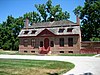 | April 20, 1978 (#78003118) | Main St. 38°49′10″N 76°44′34″W / 38.819444°N 76.742778°W / 38.819444; -76.742778 (Buck House) | Upper Marlboro | Brick dwelling built ca. 1742; now a house museum, known as Darnall's Chance |
| 20 | Butler House |  | March 14, 2005 (#05000147) | 6403 Oxon Hill Rd. 38°48′24″N 77°00′13″W / 38.806667°N 77.003611°W / 38.806667; -77.003611 (Butler House) | Oxon Hill | Dwelling constructed in 1853; part of the Multiple Property Submission for the African-American Historic Resources of Prince George's County, Maryland |
| 21 | Thomas J. Calloway House | 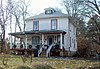 | March 14, 2005 (#05000148) | 9949 Elm St. 38°57′52″N 76°49′11″W / 38.964444°N 76.819722°W / 38.964444; -76.819722 (Thomas J. Calloway House) | Lanham | Dwelling constructed in 1910; part of the Multiple Property Submission for the African-American Historic Resources of Prince George's County, Maryland |
| 22 | Calvert Hills Historic District |  | December 23, 2002 (#02001605) | Roughly bounded by Calvert Rd., Bowdoin Ave., Erskine Rd., Calvert Park, Albion Rd., and Baltimore Ave. 38°58′28″N 76°56′05″W / 38.974444°N 76.934722°W / 38.974444; -76.934722 (Calvert Hills Historic District) | College Park | Middle-class, single-family residential neighborhood developed in the early part of the 20th century. |
| 23 | Chapel of the Incarnation |  | December 13, 2000 (#00001505) | 14070 Brandywine Rd. 38°41′51″N 76°51′10″W / 38.6975°N 76.852778°W / 38.6975; -76.852778 (Chapel of the Incarnation) | Brandywine | Mission style church built 1916-1917. |
| 24 | Civil War Fort Sites | 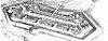 | July 15, 1974 (#74000274) | Arc of sites surrounding central Washington in Maryland, Virginia, and D.C. 38°46′00″N 77°01′40″W / 38.766667°N 77.027778°W / 38.766667; -77.027778 (Civil War Fort Sites) | National Harbor | At the outset of the Civil War in 1861, Washington became a critical target for rebel attacks but was virtually without protection. The Union Army hastily began construction of a fortified defense line around the city, the physical remnants of which encompass these 19 earthwork forts, including Fort Foote.[6] See also National Register listings in central D.C., western NW D.C., upper NW D.C., NE D.C., SE D.C., and Fairfax County, Virginia. |
| 25 | Clagett House at Cool Spring Manor | 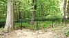 | June 3, 2011 (#11000322) | 17500 Clagett Landing Rd. 38°52′23″N 76°41′53″W / 38.873°N 76.698°W / 38.873; -76.698 (Clagett House at Cool Spring Manor) | Upper Marlboro | Greek Revival house built ca. 1830 |
| 26 | John W. Coffren House and Store |  | June 2, 1987 (#87000768) | 10007 Croom Rd. 38°45′04″N 76°45′45″W / 38.751111°N 76.7625°W / 38.751111; -76.7625 (John W. Coffren House and Store) | Croom | Dwelling built in 1861, and one room store constructed ca. 1853. |
| 27 | College Heights Estates Historic District |  | December 12, 2012 (#12001023) | Roughly bounded by Adelphi Rd., U. of Maryland College Park, University Park, Van Buren St., Wells Pkwy. 38°58′38″N 76°57′02″W / 38.9772°N 76.9505°W / 38.9772; -76.9505 (College Heights Estates Historic District) | University Park | |
| 28 | College Park Airport |  | September 23, 1977 (#77001522) | East of College Park off Kenilworth Ave. 38°58′50″N 76°55′27″W / 38.980556°N 76.924167°W / 38.980556; -76.924167 (College Park Airport) | College Park | Established in 1909; world's oldest continuously operated airport. |
| 29 | Compton Bassett |  | March 8, 1983 (#83002959) | 16508 Marlboro Pike 38°48′55″N 76°43′01″W / 38.815278°N 76.716944°W / 38.815278; -76.716944 (Compton Bassett) | Upper Marlboro | Brick Georgian house built about 1783. |
| 30 | Concord |  | May 12, 1982 (#82004681) | 8000 Walker Mill Rd. 38°52′39″N 76°52′02″W / 38.8775°N 76.867222°W / 38.8775; -76.867222 (Concord) | District Heights | Greek Revival-influenced dwelling built originally in the 1790s. |
| 31 | Content |  | September 13, 1978 (#78003119) | 14518 Church St. 38°48′54″N 76°45′12″W / 38.815°N 76.753333°W / 38.815; -76.753333 (Content) | Upper Marlboro | Frame structure built in three stages; first section constructed in 1787. |
| 32 | The Cottage |  | July 13, 1989 (#89000769) | 11904 Old Marlboro Pike 38°49′21″N 76°47′55″W / 38.8225°N 76.798611°W / 38.8225; -76.798611 (The Cottage) | Upper Marlboro | Three-part plantation house built in the 1840s with group of domestic outbuildings. |
| 33 | William W. Early House |  | June 30, 1988 (#88000984) | 13907 Cherry Tree Crossing Rd. 38°41′53″N 76°50′56″W / 38.698056°N 76.848889°W / 38.698056; -76.848889 (William W. Early House) | Brandywine | Queen Anne Victorian built in 1907 for railroad manager; privately owned. |
| 34 | Early Family Historic District | | December 12, 2012 (#12001024) | 13900-13902-13904 & 13907 Cherry Tree Crossing & 14134 Brandywine Rds. 38°41′53″N 76°50′56″W / 38.698056°N 76.848889°W / 38.698056; -76.848889 (Early Family Historic District) | Brandywine | |
| 35 | Fairmount Heights Historic District | 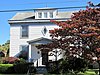 | November 18, 2011 (#11000821) | 56th Ave., Sheriff Rd., Balsamtree Dr., 62nd St. 62nd Pl., Eastern Ave. 38°54′03″N 76°54′56″W / 38.900944°N 76.915528°W / 38.900944; -76.915528 (Fairmount Heights Historic District) | Fairmount Heights | Misspelled "Fairmont" in the National Register listing |
| 36 | Fort Washington |  | October 15, 1966 (#66000965) | Fort Washington Park 38°42′38″N 77°01′49″W / 38.710556°N 77.030278°W / 38.710556; -77.030278 (Fort Washington) | Fort Washington | Site overlooking the Potomac River, original fort completed in 1809. |
| 37 | Glenn Dale Tuberculosis Hospital and Sanatorium | 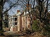 | November 18, 2011 (#11000822) | 5201 Glenn Dale Rd. 38°57′39″N 76°48′48″W / 38.960783°N 76.813472°W / 38.960783; -76.813472 (Glenn Dale Tuberculosis Hospital and Sanatorium) | Glenn Dale | |
| 38 | Don S. S. Goodloe House |  | October 13, 1988 (#88001900) | 13809 Laurel - Bowie Rd. 39°00′32″N 76°46′03″W / 39.008889°N 76.7675°W / 39.008889; -76.7675 (Don S. S. Goodloe House) | Bowie | Colonial Revival style dwelling built 1915–16. |
| 39 | Greenbelt Historic District |  | November 25, 1980 (#80004331) | Off Maryland Route 193 39°00′10″N 76°53′28″W / 39.002778°N 76.891111°W / 39.002778; -76.891111 (Greenbelt Historic District) | Greenbelt | Preserves the center of one of the few examples of the Garden City Movement in the United States. |
| 40 | James Hamilton House | Upload image | November 10, 1988 (#88002064) | 16810 Federal Hill Court 38°54′30″N 76°42′44″W / 38.908333°N 76.712222°W / 38.908333; -76.712222 (James Hamilton House) | Bowie | Late-Victorian frame dwelling constructed in the mid-1870s. |
| 41 | Hard Bargain Farm | 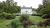 | October 8, 2014 (#14000839) | 2001 Bryan Point Rd. 38°41′21″N 77°02′41″W / 38.6891°N 77.0446°W / 38.6891; -77.0446 (Hard Bargain Farm) | Accokeek | |
| 42 | Harmony Hall |  | June 6, 1980 (#80000673) | 10511 Livingston Rd. 38°44′45″N 77°00′11″W / 38.745833°N 77.003056°W / 38.745833; -77.003056 (Harmony Hall) | Fort Washington | Georgian country house built of red brick during the 18th century. |
| 43 | Hazelwood |  | April 1, 1999 (#99000422) | 18611 Queen Anne Rd. 38°53′42″N 76°40′47″W / 38.895°N 76.679722°W / 38.895; -76.679722 (Hazelwood) | Upper Marlboro | Frame dwelling built in three discrete sections over a long period of time; the oldest section built about 1770. |
| 44 | William Hilleary House |  | July 20, 1978 (#78003116) | 4703 Annapolis Rd. 38°56′20″N 76°56′16″W / 38.938889°N 76.937778°W / 38.938889; -76.937778 (William Hilleary House) | Bladensburg | 18th-century stone, gambrel-roofed house. |
| 45 | Hilltop Manor |  | December 21, 2007 (#07001288) | 4100-4112 and 4200-4214 53rd Ave., 4100-4210 53rd Pl., and 5300-5304 Annapolis Rd. 38°56′33″N 76°55′46″W / 38.9425°N 76.929444°W / 38.9425; -76.929444 (Hilltop Manor) | Bladensburg | Brick garden apartment buildings constructed in 1942 and 1943. |
| 46 | His Lordship's Kindness |  | April 15, 1970 (#70000853) | 3.5 miles northwest of Rosaryville off Rosaryville Rd. 38°46′44″N 76°50′34″W / 38.778889°N 76.842778°W / 38.778889; -76.842778 (His Lordship's Kindness) | Rosaryville | Georgian mansion, also known as Poplar Hill, built in the 1780s; operated as historic house museum. |
| 47 | Hyattsville Armory | 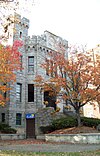 | March 27, 1980 (#80004332) | 5340 Baltimore Ave. 38°57′17″N 76°56′28″W / 38.954722°N 76.941111°W / 38.954722; -76.941111 (Hyattsville Armory) | Hyattsville | Former National Guard armory built in 1918. |
| 48 | Hyattsville Historic District |  | March 25, 1982 (#82004682) | Off U.S. Route 1 Boundary increase (listed December 15, 2004, refnum=04001356): Roughly bounded by Baltimore & Ohio railroad tracks, East-West Highway, 42nd Pl., Madison, 37th and 38th Aves., Hamilton Pl. and 37th Pl. 38°57′08″N 76°56′48″W / 38.952222°N 76.946667°W / 38.952222; -76.946667 (Hyattsville Historic District) | Hyattsville | Residential neighborhood that exhibit late-19th and early-20th century design characteristics. |
| 49 | Kingston |  | July 21, 1978 (#78003120) | 5415 Old Crain Highway 38°48′52″N 76°45′21″W / 38.814444°N 76.755833°W / 38.814444; -76.755833 (Kingston) | Upper Marlboro | Believed to be the oldest building remaining in the town of Upper Marlboro and may have been built, at least in part, before 1730. |
| 50 | Langley Park |  | August 29, 2008 (#08000809) | 8151 15th Avenue 38°59′27″N 76°58′53″W / 38.990833°N 76.981389°W / 38.990833; -76.981389 (Langley Park) | Langley Park | Georgian Revival style estate mansion built in 1924. |
| 51 | Laurel High School | 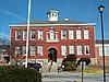 | June 27, 1979 (#79003170) | 700 block of Montgomery St. 39°06′25″N 76°51′20″W / 39.106944°N 76.855556°W / 39.106944; -76.855556 (Laurel High School) | Laurel | Original building (not current one) for Laurel High School (Maryland) |
| 52 | Laurel Railroad Station |  | March 30, 1973 (#73002165) | E. Main St. 39°06′08″N 76°50′27″W / 39.102222°N 76.840833°W / 39.102222; -76.840833 (Laurel Railroad Station) | Laurel | Passenger rail station originally constructed in 1884, for the Baltimore and Ohio Railroad. |
| 53 | Marenka House | 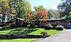 | September 8, 2017 (#100001581) | 7300 Radcliffe Dr. 38°58′34″N 76°54′50″W / 38.976224°N 76.91396°W / 38.976224; -76.91396 (Marenka House) | College Park | |
| 54 | Marietta |  | July 25, 1994 (#94000729) | 5626 Bell Station Rd. 38°57′56″N 76°47′57″W / 38.965556°N 76.799167°W / 38.965556; -76.799167 (Marietta) | Glenn Dale | Federal brick house begun about 1812. |
| 55 | Market Master's House |  | March 29, 1990 (#90000553) | 4006 48th St. 38°56′21″N 76°56′13″W / 38.939167°N 76.936944°W / 38.939167; -76.936944 (Market Master's House) | Bladensburg | An 18th-century vernacular Colonial-era stone dwelling with 20th-century additions. |
| 56 | Melford |  | April 6, 1988 (#88000271) | 17100 block of Melford Boulevard; Science Drive in Maryland Science & Technology Center 38°57′35″N 76°42′34″W / 38.959722°N 76.709444°W / 38.959722; -76.709444 (Melford) | Bowie | Greek Revival style plantation home built in the 1840s. |
| 57 | Melwood Park |  | October 8, 1976 (#76002169) | 10908 Old Marlboro Pike 38°48′45″N 76°49′01″W / 38.8125°N 76.816944°W / 38.8125; -76.816944 (Melwood Park) | Upper Marlboro | Brick dwelling believed to have been built by Ignatius Digges (1707-1785) ca. 1750. |
| 58 | Montpelier |  | April 17, 1970 (#70000852) | 2.1 miles east of Laurel on Maryland Route 197 39°03′48″N 76°50′42″W / 39.063333°N 76.845°W / 39.063333; -76.845 (Montpelier) | Laurel | Georgian style home most likely constructed between 1781 and 1785; opened as a public tourist attraction in 1985. |
| 59 | Mount Hope | 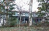 | November 29, 1978 (#78003180) | 1 Cheverly Circle 38°55′20″N 76°54′47″W / 38.922222°N 76.913056°W / 38.922222; -76.913056 (Mount Hope) | Cheverly | Frame house built in two stages; home of Chverly's founder Robert Marshall. |
| 60 | Mount Lubentia |  | July 9, 1987 (#87001033) | 603 Largo Rd. 38°52′55″N 76°48′59″W / 38.881944°N 76.816389°W / 38.881944; -76.816389 (Mount Lubentia) | Largo | Federal-style brick house built about 1798. |
| 61 | Mount Pleasant |  | November 29, 1972 (#72001482) | Mt. Pleasant Rd. 38°50′34″N 76°42′40″W / 38.8428°N 76.7111°W / 38.8428; -76.7111 (Mount Pleasant) | Upper Marlboro | Georgian dwelling in brick built about 1750. |
| 62 | Mount Rainier Historic District |  | September 7, 1990 (#90001319) | Roughly bounded by Arundel St., 37th St., Bladensburg Rd., and Eastern Ave. 38°56′21″N 76°57′42″W / 38.9392°N 76.9617°W / 38.9392; -76.9617 (Mount Rainier Historic District) | Mount Rainier | Community of modestly scaled, detached, single-family, frame houses developed ca. 1900-1940. |
| 63 | Moyaone Reserve |  | October 7, 2020 (#100005659) | Roughly bounded by Bryan Point Rd., Piscataway Park, Overlook Dr./Old Landing Rd., and Farmington Rd. West 38°41′27″N 77°01′25″W / 38.6909°N 77.0237°W / 38.6909; -77.0237 (Moyaone Reserve) | Accokeek | |
| 64 | National Archives Archeological Site |  | August 22, 1996 (#96000901) | Address Restricted | College Park | Remains from prehistoric settlements during the Late Archaic period, c. 4000-1500 B.C. |
| 65 | New Town Center |  | October 23, 2018 (#100002683) | 6505 & 6525 Belcrest Rd., 3700 East-West Hwy. 38°58′04″N 76°57′10″W / 38.9677°N 76.9529°W / 38.9677; -76.9529 (New Town Center) | Hyattsville | |
| 66 | North Brentwood Historic District |  | November 21, 2003 (#03001174) | Roughly bounded by 39th Pl., Allison St., Rhode Island Ave., and Webster St. 38°56′41″N 76°57′08″W / 38.9447°N 76.9522°W / 38.9447; -76.9522 (North Brentwood Historic District) | North Brentwood | Earliest incorporated African American community in the county; working-class suburban community developed 1891-1950. |
| 67 | Nottingham Site | Upload image | May 12, 1975 (#75002083) | Address Restricted | Upper Marlboro | May correspond to the village of Mattpament depicted on John Smith’s 1608 map. |
| 68 | O'Dea House |  | June 4, 1987 (#87000899) | 5804 Ruatan St. 38°59′41″N 76°54′47″W / 38.9947°N 76.9131°W / 38.9947; -76.9131 (O'Dea House) | Berwyn Heights | Queen Anne-style dwelling built in 1888. |
| 69 | Old Town College Park |  | December 4, 2012 (#12000993) | Roughly bounded by Yale, & Columbia Aves., Calvert Rd., & UM Campus 38°58′50″N 76°56′02″W / 38.9806°N 76.9340°W / 38.9806; -76.9340 (Old Town College Park) | College Park | |
| 70 | Oxon Cove Park |  | September 2, 2003 (#03000869) | Government Farm Rd. 38°48′08″N 77°00′28″W / 38.8022°N 77.0078°W / 38.8022; -77.0078 (Oxon Cove Park) | Oxon Hill | Property developed as a plantation, an institutional agricultural complex, and a farm museum. |
| 71 | Oxon Hill Manor | 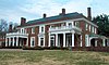 | June 9, 1978 (#78003117) | 6701 Oxon Hill Rd. 38°47′47″N 77°00′19″W / 38.7964°N 77.0053°W / 38.7964; -77.0053 (Oxon Hill Manor) | Oxon Hill | neo-Georgian house designed in 1928 for Sumner Welles. |
| 72 | Peace Cross |  | September 8, 2015 (#15000572) | Annapolis Rd. & Baltimore Ave. 38°56′22″N 76°56′27″W / 38.9394°N 76.9409°W / 38.9394; -76.9409 (Peace Cross) | Bladensburg | AKA the World War I memorial |
| 73 | Piscataway Park |  | October 15, 1966 (#66000144) | East of the Potomac River and south of Piscataway Creek 38°41′05″N 77°03′05″W / 38.6847°N 77.0514°W / 38.6847; -77.0514 (Piscataway Park) | Accokeek | Location of Marshall Hall and the National Colonial Farm. |
| 74 | Piscataway Village Historic District |  | December 15, 2011 (#11000919) | Bounded by Piscataway Cr., Piscataway Rd. & Livingston Rd. 38°41′47″N 76°58′31″W / 38.6965°N 76.9752°W / 38.6965; -76.9752 (Piscataway Village Historic District) | Clinton vicinity | |
| 75 | Pleasant Hills |  | August 6, 1980 (#80004334) | 7001 Croom Station Rd. 38°47′35″N 76°45′51″W / 38.7931°N 76.7642°W / 38.7931; -76.7642 (Pleasant Hills) | Upper Marlboro | Brick dwelling with Greek Revival detailing, constructed ca. 1810. |
| 76 | Pleasant Prospect | 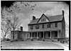 | April 30, 1976 (#76002168) | 12806 Woodmore Rd. 38°56′04″N 76°47′00″W / 38.9344°N 76.7833°W / 38.9344; -76.7833 (Pleasant Prospect) | Mitchellville | Brick dwelling built by Isaac Duckett in 1798. |
| 77 | Ridgeley School |  | May 1, 2015 (#14001093) | 8507 Central Ave. 38°53′20″N 76°51′37″W / 38.8888°N 76.8604°W / 38.8888; -76.8604 (Ridgeley School) | Capitol Heights | |
| 78 | Ridgley Methodist Episcopal Church |  | March 14, 2005 (#05000149) | 8900 Central Ave. 38°53′35″N 76°51′09″W / 38.8931°N 76.8525°W / 38.8931; -76.8525 (Ridgley Methodist Episcopal Church) | Landover | One-story frame church constructed in 1921; part of the Multiple Property Submission for the African-American Historic Resources of Prince George's County, Maryland. |
| 79 | Riverdale Park Historic District |  | December 23, 2002 (#02001608) | Roughly bounded by Tuckerman St., Taylor Rd., Oglethorpe St., the B&O railroad tracks, Madison St. and Baltimore Ave. 38°57′59″N 76°56′12″W / 38.9664°N 76.9367°W / 38.9664; -76.9367 (Riverdale Park Historic District) | Riverdale Park | Early railroad suburb northeast of Washington, D.C. developed starting in 1889. |
| 80 | Riversdale | 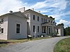 | April 11, 1973 (#73002166) | Riverdale Rd. between 18th and Taylor Sts. 38°57′37″N 76°55′55″W / 38.9603°N 76.9319°W / 38.9603; -76.9319 (Riversdale) | Riverdale Park | Five-part, large-scale late Georgian mansion with Federal interior, built between 1801 and 1807. |
| 81 | St. Ignatius Church | 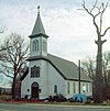 | June 27, 1974 (#74002201) | 2317 Brinkley Rd. 38°48′16″N 76°58′01″W / 38.8044°N 76.9669°W / 38.8044; -76.9669 (St. Ignatius Church) | Oxon Hill | Catholic parish church constructed between 1890 and 1891. |
| 82 | St. John's Church | 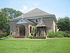 | April 8, 1974 (#74002202) | 9801 Livingston Rd. 38°45′18″N 77°00′04″W / 38.755°N 77.001111°W / 38.755; -77.001111 (St. John's Church) | Fort Washington | Oldest church site the county dating to 1692; church structure dates to 1767-1768. |
| 83 | St. Mary's Beneficial Society Hall |  | March 14, 2005 (#05000150) | 14825 Pratt St. 38°49′11″N 76°44′53″W / 38.819722°N 76.748056°W / 38.819722; -76.748056 (St. Mary's Beneficial Society Hall) | Upper Marlboro | Multi-purpose building constructed in 1892; part of the Multiple Property Submission for the African-American Historic Resources of Prince George's County, Maryland. |
| 84 | Saint Mary's Rectory |  | September 10, 1987 (#87001572) | 16305 Saint Mary's Church Rd. 38°35′05″N 76°43′22″W / 38.584722°N 76.722778°W / 38.584722; -76.722778 (Saint Mary's Rectory) | Aquasco | Frame dwelling built in 1849 and enlarged to twice its size in 1856. |
| 85 | St. Matthew's Church | 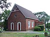 | April 10, 1972 (#72001481) | Addison Rd. and 62nd Pl. 38°54′06″N 76°54′34″W / 38.901667°N 76.909444°W / 38.901667; -76.909444 (St. Matthew's Church) | Seat Pleasant | Brick Episcopal church also known as Addison Chapel. |
| 86 | St. Paul's Parish Church | 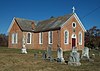 | September 15, 1977 (#77001521) | 13500 Baden Westwood Road off Maryland Route 381 38°39′40″N 76°46′20″W / 38.661111°N 76.772222°W / 38.661111; -76.772222 (St. Paul's Parish Church) | Brandywine | Brick Episcopal church dating to 1733. |
| 87 | St. Thomas' Church |  | December 13, 2000 (#00001504) | 14300 St. Thomas Church Rd. 38°44′56″N 76°45′24″W / 38.748889°N 76.756667°W / 38.748889; -76.756667 (St. Thomas' Church) | Upper Marlboro | Brick Episcopal church constructed between 1742 and 1745. |
| 88 | St. Thomas' Episcopal Parish Historic District |  | December 30, 2011 (#11000963) | From east side of Croom Rd. along north & south sides of St. Thomas Church Rd., eastward for about 1500 ft. 38°44′51″N 76°45′29″W / 38.747469°N 76.758103°W / 38.747469; -76.758103 (St. Thomas' Episcopal Parish Historic District) | Upper Marlboro vicinity | |
| 89 | Harry Smith House | 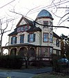 | May 4, 1993 (#93000342) | 4707 Oliver St. 38°57′39″N 76°56′01″W / 38.960833°N 76.933611°W / 38.960833; -76.933611 (Harry Smith House) | Riverdale Park | Queen Anne-style frame dwelling, built in 1890. |
| 90 | Snow Hill |  | August 13, 1974 (#74002200) | 13301 Laurel-Bowie Road (Maryland 197), Maryland Route 197 39°04′32″N 76°50′35″W / 39.075556°N 76.843056°W / 39.075556; -76.843056 (Snow Hill) | Laurel | Late Georgian style house built between 1799 and 1801. |
| 91 | Spacecraft Magnetic Test Facility |  | October 3, 1985 (#85002811) | Goddard Space Flight Center 39°00′24″N 76°49′31″W / 39.006667°N 76.825278°W / 39.006667; -76.825278 (Spacecraft Magnetic Test Facility) | Greenbelt | Built in 1966 to allow the evaluation of magnetic movement in spacecraft. |
| 92 | Suitland Parkway | 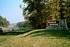 | June 2, 1995 (#95000604) | From the Anacostia River in the District of Columbia to Pennsylvania Ave. in Prince George's County 38°50′29″N 76°55′17″W / 38.841389°N 76.921389°W / 38.841389; -76.921389 (Suitland Parkway) | Suitland | Part of the Multiple Property Submission for the Parkways of the National Capital Region. |
| 93 | Sunnyside | 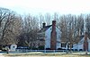 | May 29, 1987 (#87000840) | 16005 Dr. Bowen Rd. 38°35′05″N 76°43′41″W / 38.584722°N 76.728056°W / 38.584722; -76.728056 (Sunnyside) | Aquasco | Frame dwelling dating to 1844. |
| 94 | Surratt House |  | March 30, 1973 (#73002164) | 9110 Brandywine Rd. 38°45′53″N 76°53′52″W / 38.764722°N 76.897778°W / 38.764722; -76.897778 (Surratt House) | Clinton | Home owned by Mary Surratt that served as an arms and ammunition stop for John Wilkes Booth during his flight after shooting Lincoln; now operated as house museum. |
| 95 | John H. Traband House |  | March 22, 1984 (#84001856) | 14204 Old Marlboro Pike 38°49′08″N 76°45′32″W / 38.818889°N 76.758889°W / 38.818889; -76.758889 (John H. Traband House) | Upper Marlboro | Queen Anne influenced frame structure built between 1895 and 1897. |
| 96 | University Park Historic District |  | October 10, 1996 (#96001084) | Bounded by Baltimore Ave., Maryland Route 410, and Adelphi Rd. 38°58′17″N 76°56′36″W / 38.971389°N 76.943333°W / 38.971389; -76.943333 (University Park Historic District) | University Park | Middle-class, single-family residential neighborhood developed in the early part of the 20th century. |
| 97 | Upper Marlboro Residential Historic District | Upload image | December 12, 2012 (#12001026) | Bounded by 14204 Old Marlboro Pike, 14519 Elm & 14508 Main Sts., Western Branch & 5600 Old Crain Hwy. 38°48′56″N 76°45′16″W / 38.815619°N 76.754526°W / 38.815619; -76.754526 (Upper Marlboro Residential Historic District) | Upper Marlboro | |
| 98 | US Post Office-Hyattsville Main | 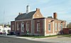 | July 24, 1986 (#86001906) | 4325 Gallatin St. 38°57′10″N 76°56′29″W / 38.952778°N 76.941389°W / 38.952778; -76.941389 (US Post Office-Hyattsville Main) | Hyattsville | Colonial Revival building constructed in 1935. |
| 99 | Villa DeSales | 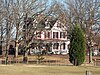 | July 14, 1988 (#88001063) | 22410 Aquasco Rd. 38°34′58″N 76°43′19″W / 38.582778°N 76.721944°W / 38.582778; -76.721944 (Villa DeSales) | Aquasco | Frame High Victorian Gothic dwelling built in 1877-1878. |
| 100 | George Washington House | 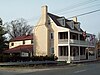 | August 7, 1974 (#74002198) | Baltimore Ave. at Upshur St. 38°56′28″N 76°56′29″W / 38.941111°N 76.941389°W / 38.941111; -76.941389 (George Washington House) | Bladensburg | Brick structure constructed in 1732; also known as Indian Queen Tavern. |
| 101 | Waverly | 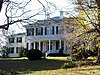 | June 2, 1987 (#87000800) | 8901 Duvall Rd. 38°45′59″N 76°44′14″W / 38.766389°N 76.737222°W / 38.766389; -76.737222 (Waverly) | Croom | Italianate style frame house constructed in 1855. |
| 102 | West Riverdale Historic District |  | December 23, 2002 (#02001609) | Roughly bounded by Maryland Route 410, 44th Place, the Hyattsville city limits, and 43rd St. 38°57′48″N 76°56′31″W / 38.963333°N 76.941944°W / 38.963333; -76.941944 (West Riverdale Historic District) | Riverdale Park | Diverse residential community that includes the former Eugene Leland Memorial Hospital. |
| 103 | Williams Plains | 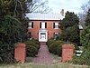 | November 28, 1980 (#80004329) | Maryland Route 3 in White Marsh Recreational Park 38°58′35″N 76°43′19″W / 38.976389°N 76.721944°W / 38.976389; -76.721944 (Williams Plains) | Bowie | Early to mid-19th century brick dwelling. |
| 104 | Woodstock | 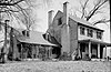 | September 21, 1987 (#87001573) | 8706 SE. Crain Highway 38°46′10″N 76°48′07″W / 38.769444°N 76.801944°W / 38.769444; -76.801944 (Woodstock) | Upper Marlboro | Mid-19th century plantation house with decorative elements in the Greek Revival style. |
| 105 | Woodyard Archeological Site |  | December 19, 1974 (#74002199) | Woodyard Rd.[7] 38°47′04″N 76°50′49″W / 38.78442°N 76.84702°W / 38.78442; -76.84702 (Woodyard Archeological Site) | Clinton | Site of a large brick mansion known as "The Woodyard" and built in the 18th century. |
| 106 | Wyoming | 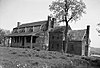 | January 24, 1980 (#80004330) | South of Clinton on Thrift Rd. 38°43′38″N 76°55′09″W / 38.727222°N 76.919167°W / 38.727222; -76.919167 (Wyoming) | Clinton | Frame dwelling dating to the 18th century; ancestral home of the Marbury family. |
See also
Wikimedia Commons has media related to National Register of Historic Places in Prince George's County, Maryland.
- List of National Historic Landmarks in Maryland
- National Register of Historic Places listings in Maryland
References
- ^ The latitude and longitude information provided in this table was derived originally from the National Register Information System, which has been found to be fairly accurate for about 99% of listings. Some locations in this table may have been corrected to current GPS standards.
- ^ National Park Service, United States Department of the Interior, "National Register of Historic Places: Weekly List Actions", retrieved May 10, 2024.
- ^ Numbers represent an alphabetical ordering by significant words. Various colorings, defined here, differentiate National Historic Landmarks and historic districts from other NRHP buildings, structures, sites or objects.
- ^ "National Register Information System". National Register of Historic Places. National Park Service. April 24, 2008.
- ^ The eight-digit number below each date is the number assigned to each location in the National Register Information System database, which can be viewed by clicking the number.
- ^ Dillon, James (July 30, 1976), National Register of Historic Places Inventory — Nomination Form for Federal Properties: Defenses of Washington (Civil War) (PDF), archived (PDF) from the original on February 15, 2017, retrieved February 18, 2019.
- ^ Location derived from the Maryland Historical Trust; the NRIS lists the site as "Address Restricted"
- v
- t
- e

by county
 Category:National Register of Historic Places in Maryland
 Portal:National Register of Historic Places


| ||
|---|---|---|
| Administration |  | |
| Landmarks & major employers | ||
| Transportation |
| |
| Culture & history |
| |
| Higher education | ||
| Parks & natural areas | ||


