National Register of Historic Places listings in Orange County, Florida

This is a list of the National Register of Historic Places listings in Orange County, Florida.
This is intended to be a complete list of the properties and districts on the National Register of Historic Places in Orange County, Florida, United States. The locations of National Register properties and districts for which the latitude and longitude coordinates are included below, may be seen in an online map.[1]
There are 57 properties and districts listed on the National Register in the county. Another 2 properties were once listed but have been removed.
This National Park Service list is complete through NPS recent listings posted May 10, 2024.[2]
Map all coordinates using OpenStreetMap
Download coordinates as:
- KML
- GPX (all coordinates)
- GPX (primary coordinates)
- GPX (secondary coordinates)
| Alachua - Baker - Bay - Bradford - Brevard - Broward - Calhoun - Charlotte - Citrus - Clay - Collier - Columbia - DeSoto - Dixie - Duval - Escambia - Flagler - Franklin - Gadsden - Gilchrist - Glades - Gulf - Hamilton - Hardee - Hendry - Hernando - Highlands - Hillsborough (Tampa) - Holmes - Indian River - Jackson - Jefferson - Lafayette - Lake - Lee - Leon - Levy - Liberty - Madison - Manatee - Marion - Martin - Miami-Dade (Miami) - Monroe - Nassau - Okaloosa - Okeechobee - Orange - Osceola - Palm Beach - Pasco - Pinellas - Polk - Putnam - St. Johns - St. Lucie - Santa Rosa - Sarasota - Seminole - Sumter - Suwannee - Taylor - Union - Volusia - Wakulla - Walton - Washington |
Current listings
| [3] | Name on the Register[4] | Image | Date listed[5] | Location | City or town | Description |
|---|---|---|---|---|---|---|
| 1 | 1890 Windermere School | 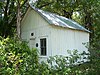 | June 5, 2003 (#03000509) | 113 West Seventh Avenue 28°29′35″N 81°32′07″W / 28.493056°N 81.535278°W / 28.493056; -81.535278 (1890 Windermere School) | Windermere | |
| 2 | All Saints Episcopal Church |  | January 7, 2000 (#99001647) | 338 East Lyman Avenue 28°35′40″N 81°20′55″W / 28.594444°N 81.348611°W / 28.594444; -81.348611 (All Saints Episcopal Church) | Winter Park | |
| 3 | Apopka Seaboard Air Line Railway Depot | 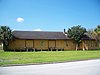 | March 15, 1993 (#93000134) | 36 East Station Street 28°40′11″N 81°30′39″W / 28.669722°N 81.510833°W / 28.669722; -81.510833 (Apopka Seaboard Air Line Railway Depot) | Apopka | |
| 4 | S. Howard Atha House |  | September 2, 2009 (#09000672) | 1101 West Princeton Street 28°34′17″N 81°23′41″W / 28.571389°N 81.394722°W / 28.571389; -81.394722 (S. Howard Atha House) | Orlando | |
| 5 | Atlantic Coast Line Station | 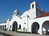 | July 28, 2022 (#100007973) | 1400 Sligh Blvd. 28°31′36″N 81°22′55″W / 28.526639°N 81.382041°W / 28.526639; -81.382041 (Atlantic Coast Line Station) | Orlando | |
| 6 | Baptist Terrace Apartments | Upload image | July 13, 2022 (#100007476) | 414 East Pine St. 28°32′28″N 81°22′18″W / 28.541115°N 81.371682°W / 28.541115; -81.371682 (Baptist Terrace Apartments) | Orlando | |
| 7 | Robert Bruce Barbour House |  | December 31, 2008 (#08001244) | 656 Park Avenue North 28°36′10″N 81°21′04″W / 28.602667°N 81.351056°W / 28.602667; -81.351056 (Robert Bruce Barbour House) | Winter Park | |
| 8 | Edward Hill Brewer House |  | April 22, 1982 (#82002378) | 240 Trismen Terrace 28°36′03″N 81°20′33″W / 28.600833°N 81.3425°W / 28.600833; -81.3425 (Edward Hill Brewer House) | Winter Park | |
| 9 | J. J. Bridges House |  | January 26, 1984 (#84000932) | 704 South Kuhl Avenue 28°31′59″N 81°22′38″W / 28.533056°N 81.377222°W / 28.533056; -81.377222 (J. J. Bridges House) | Orlando | |
| 10 | Carroll Building |  | March 4, 1993 (#93000135) | 407-409 South Park Avenue 28°40′17″N 81°30′34″W / 28.671389°N 81.509444°W / 28.671389; -81.509444 (Carroll Building) | Apopka | |
| 11 | Church of the Good Shepherd |  | March 28, 2011 (#11000144) | 331 Lake Avenue 28°37′11″N 81°22′05″W / 28.619722°N 81.368056°W / 28.619722; -81.368056 (Church of the Good Shepherd) | Maitland | part of the Florida's Carpenter Gothic Churches MPS |
| 12 | Comstock-Harris House |  | January 13, 1983 (#83001432) | 724 Bonita Drive 28°36′19″N 81°20′08″W / 28.605278°N 81.335556°W / 28.605278; -81.335556 (Comstock-Harris House) | Winter Park | |
| 13 | Downtown Winter Park Historic District |  | May 3, 2011 (#11000158) | Roughly Canton Ave, Center St, Comstock Ave, New York Ave, 28°35′50″N 81°21′07″W / 28.597222°N 81.351944°W / 28.597222; -81.351944 (Downtown Winter Park Historic District) | Winter Park | |
| 14 | Eatonville Historic District |  | February 3, 1998 (#97001214) | Roughly bounded by Wymore Road, Eaton Street, Fords and East Avenues, and Ruffel and Clark Streets 28°37′04″N 81°22′52″W / 28.617778°N 81.381111°W / 28.617778; -81.381111 (Eatonville Historic District) | Eatonville | |
| 15 | First Church of Christ Scientist |  | June 3, 1980 (#80000956) | 24 North Rosalind Avenue 28°32′34″N 81°22′35″W / 28.542778°N 81.376389°W / 28.542778; -81.376389 (First Church of Christ Scientist) | Orlando | |
| 16 | Gary-Morgan House |  | March 2, 2015 (#15000062) | 1041 Osceola Ave. 28°35′52″N 81°20′18″W / 28.5979°N 81.3384°W / 28.5979; -81.3384 (Gary-Morgan House) | Winter Park | |
| 17 | Siegmund and Marilyn Goldman House |  | February 4, 2019 (#100003411) | 1670 Huron Trail 28°38′04″N 81°20′53″W / 28.6345°N 81.3481°W / 28.6345; -81.3481 (Siegmund and Marilyn Goldman House) | Maitland | Designed by architect Nils M. Schweizer in 1964. |
| 18 | Griffin Park Historic District |  | July 18, 1996 (#96000784) | Roughly bounded by Avondale and South Division Avenues, Carter Street, and Interstate 4 28°31′58″N 81°23′10″W / 28.532778°N 81.386111°W / 28.532778; -81.386111 (Griffin Park Historic District) | Orlando | |
| 19 | Holden-Parramore Historic District |  | September 23, 2009 (#09000746) | Bounded by West Church Street, South Division Avenue, Long Street, McFall Avenue, and South Parramore Avenue 28°32′18″N 81°23′13″W / 28.538322°N 81.386917°W / 28.538322; -81.386917 (Holden-Parramore Historic District) | Orlando | |
| 20 | John N. Huttig Estate |  | January 21, 1993 (#91001776) | 435 Peachtree Road 28°33′14″N 81°23′10″W / 28.553889°N 81.386111°W / 28.553889; -81.386111 (John N. Huttig Estate) | Orlando | Demolished in 2005, entry gate and garden cottage remain |
| 21 | Interlachen Avenue Historic District |  | November 30, 2011 (#11000861) | Roughly bounded by S. Knowles, E. New England, S. Interlachen Aves., E. Morse Blvd., Lincoln & E. Canton Aves. 28°35′58″N 81°20′55″W / 28.599444°N 81.348611°W / 28.599444; -81.348611 (Interlachen Avenue Historic District) | Winter Park | |
| 22 | Jack Kerouac House |  | February 6, 2013 (#12001254) | 1418 Clouser Ave. 28°33′52″N 81°23′30″W / 28.564528°N 81.391547°W / 28.564528; -81.391547 (Jack Kerouac House) | Orlando | |
| 23 | Knowles Memorial Chapel |  | December 8, 1997 (#97001448) | 1000 Holt Avenue 28°35′32″N 81°20′54″W / 28.592222°N 81.348333°W / 28.592222; -81.348333 (Knowles Memorial Chapel) | Winter Park | On the Rollins College campus |
| 24 | Lake Adair-Lake Concord Historic District |  | December 30, 2011 (#11000958) | Roughly Golfview St., Edgewater Ct., Alameda St., & Peachtree Rd. 28°33′23″N 81°23′28″W / 28.556349°N 81.391053°W / 28.556349; -81.391053 (Lake Adair-Lake Concord Historic District) | Orlando | |
| 25 | Lake Eola Heights Historic District |  | January 16, 1992 (#91001912) | Roughly bounded by Hillcrest Street, North Hyer Avenue, Ridgewood Street, and North Magnolia Avenue 28°32′57″N 81°22′15″W / 28.549167°N 81.370833°W / 28.549167; -81.370833 (Lake Eola Heights Historic District) | Orlando | |
| 26 | Lake Ivanhoe Historic Residential District |  | December 20, 2010 (#10001042) | Roughly Orlando St., Interstate 4, Lakeview St., Edgewater Dr. 28°34′01″N 81°22′55″W / 28.566944°N 81.381944°W / 28.566944; -81.381944 (Lake Ivanhoe Historic Residential District) | Orlando | |
| 27 | Lake Lawsona Historic District |  | April 3, 2019 (#100003410) | Bounded by South & Robinson Sts., Summerlin & Hampton Aves. 28°32′34″N 81°21′41″W / 28.5429°N 81.3614°W / 28.5429; -81.3614 (Lake Lawsona Historic District) | Orlando | |
| 28 | James Laughlin House | 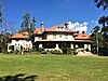 | June 28, 2016 (#16000423) | 5538 Sydonie Dr. 28°44′30″N 81°36′04″W / 28.741803°N 81.601101°W / 28.741803; -81.601101 (James Laughlin House) | Zellwood | |
| 29 | Maitland Art Center |  | November 17, 1982 (#82001036) | 231 West Packwood Avenue 28°37′32″N 81°22′03″W / 28.625556°N 81.3675°W / 28.625556; -81.3675 (Maitland Art Center) | Maitland | 1937 art gallery is one of the few examples of Mayan Revival architecture in the Southeast. Designated as a National Historic Landmark on August 25, 2014 (Reference No. 14000920). |
| 30 | Mitchell-Tibbetts House |  | November 7, 1991 (#91001661) | 21 East Orange Street 28°40′40″N 81°30′40″W / 28.677778°N 81.511111°W / 28.677778; -81.511111 (Mitchell-Tibbetts House) | Apopka | |
| 31 | Mizell-Leu House Historic District |  | December 29, 1994 (#94001495) | 1730 North Forest Avenue 28°34′03″N 81°21′26″W / 28.5675°N 81.357222°W / 28.5675; -81.357222 (Mizell-Leu House Historic District) | Orlando | |
| 32 | Ocoee Christian Church | 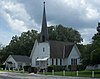 | March 28, 1997 (#97000277) | 15 South Bluford Avenue 28°34′07″N 81°32′40″W / 28.568611°N 81.544444°W / 28.568611; -81.544444 (Ocoee Christian Church) | Ocoee | |
| 33 | Old Orlando Railroad Depot |  | April 22, 1976 (#76000604) | Depot Place and West Church Street 28°32′22″N 81°22′50″W / 28.539444°N 81.380556°W / 28.539444; -81.380556 (Old Orlando Railroad Depot) | Orlando | |
| 34 | Orlando Utilities Commission Administration Building |  | June 7, 2012 (#12000321) | 500 S. Orange St. 28°32′12″N 81°22′43″W / 28.536609°N 81.378688°W / 28.536609; -81.378688 (Orlando Utilities Commission Administration Building) | Orlando | Now the Aloft Hotel |
| 35 | Palm Cottage Gardens |  | November 7, 2000 (#00000982) | 2267 Hempel Avenue 28°32′01″N 81°31′20″W / 28.533611°N 81.522222°W / 28.533611; -81.522222 (Palm Cottage Gardens) | Gotha | |
| 36 | Cal Palmer Memorial Building |  | November 29, 1995 (#95001364) | 502 Main Street 28°29′43″N 81°32′07″W / 28.495278°N 81.535278°W / 28.495278; -81.535278 (Cal Palmer Memorial Building) | Windermere | |
| 37 | Dr. P. Phillips House |  | July 10, 1979 (#79000685) | 135 Lucerne Circle, Northeast 28°32′08″N 81°22′34″W / 28.535556°N 81.376111°W / 28.535556; -81.376111 (Dr. P. Phillips House) | Orlando | |
| 38 | Albin Polasek House and Studio |  | May 2, 2000 (#99000767) | 633 Osceola Avenue 28°35′47″N 81°20′39″W / 28.596389°N 81.344167°W / 28.596389; -81.344167 (Albin Polasek House and Studio) | Winter Park | |
| 39 | Rogers Building |  | July 7, 1983 (#83001433) | 37-39 South Magnolia Avenue 28°32′34″N 81°22′14″W / 28.542778°N 81.370556°W / 28.542778; -81.370556 (Rogers Building) | Orlando | |
| 40 | Rosemere Historic District |  | October 21, 2009 (#09000844) | Roughly bounded by East Harvard Street, North Orange Avenue, Cornell Avenue, and East Vanderbilt Street 28°34′10″N 81°22′26″W / 28.569444°N 81.373889°W / 28.569444; -81.373889 (Rosemere Historic District) | Orlando | |
| 41 | Annie Russell Theatre |  | July 15, 1998 (#98000863) | 1000 Holt Avenue 28°35′33″N 81°20′53″W / 28.5925°N 81.348056°W / 28.5925; -81.348056 (Annie Russell Theatre) | Winter Park | On the Rollins College campus |
| 42 | Ryan & Company Lumber Yard |  | February 25, 1993 (#93000074) | 215 East Fifth Street 28°40′18″N 81°30′27″W / 28.671667°N 81.5075°W / 28.671667; -81.5075 (Ryan & Company Lumber Yard) | Apopka | |
| 43 | Luther F. Tilden House |  | November 15, 1996 (#96001337) | 940 Tildenville School Road 28°33′28″N 81°36′37″W / 28.557778°N 81.610278°W / 28.557778; -81.610278 (Luther F. Tilden House) | Winter Garden | |
| 44 | Tinker Building |  | July 17, 1980 (#80000957) | 16-18 West Pine Street 28°32′27″N 81°22′47″W / 28.540833°N 81.379722°W / 28.540833; -81.379722 (Tinker Building) | Orlando | |
| 45 | Tinker Field |  | May 14, 2004 (#04000456) | 1610 West Church Street 28°32′27″N 81°24′16″W / 28.540833°N 81.404444°W / 28.540833; -81.404444 (Tinker Field) | Orlando | |
| 46 | Twin Mounds Archeological District | Upload image | January 19, 1992 (#91001957) | Address Restricted | Sorrento | |
| 47 | Waite-Davis House | 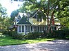 | August 2, 1990 (#90001127) | 5 South Central Avenue 28°40′39″N 81°30′41″W / 28.6775°N 81.511389°W / 28.6775; -81.511389 (Waite-Davis House) | Apopka | |
| 48 | Thomas Picton Warlow Sr. House |  | October 8, 2009 (#09000808) | 701 Driver Avenue 28°35′30″N 81°23′05″W / 28.591667°N 81.384722°W / 28.591667; -81.384722 (Thomas Picton Warlow Sr. House) | Winter Park | |
| 49 | William H. Waterhouse House |  | February 2, 1983 (#83001434) | 820 South Lake Lily Drive 28°37′15″N 81°22′02″W / 28.620833°N 81.367222°W / 28.620833; -81.367222 (William H. Waterhouse House) | Maitland | |
| 50 | Well'sbuilt Hotel |  | February 4, 2000 (#00000006) | 511 West South Street 28°32′17″N 81°23′09″W / 28.538056°N 81.385833°W / 28.538056; -81.385833 (Well'sbuilt Hotel) | Orlando | |
| 51 | Windermere Town Hall |  | June 3, 1994 (#94000539) | 520 Main Street 28°29′42″N 81°32′10″W / 28.495°N 81.536111°W / 28.495; -81.536111 (Windermere Town Hall) | Windermere | |
| 52 | Winter Garden Downtown Historic District |  | August 1, 1996 (#96000850) | Roughly bounded by Woodland, Tremaine, Henderson, and Lake View Streets 28°33′56″N 81°35′08″W / 28.565556°N 81.585556°W / 28.565556; -81.585556 (Winter Garden Downtown Historic District) | Winter Garden | |
| 53 | Winter Garden Historic Residential District |  | August 1, 1996 (#96000849) | Roughly bounded by Plant, Boyd, Tilden, and Central Streets 28°34′01″N 81°35′25″W / 28.566944°N 81.590278°W / 28.566944; -81.590278 (Winter Garden Historic Residential District) | Winter Garden | |
| 54 | Winter Park Country Club and Golf Course |  | September 17, 1999 (#99001148) | 761 Old England Avenue 28°36′15″N 81°21′12″W / 28.604167°N 81.353333°W / 28.604167; -81.353333 (Winter Park Country Club and Golf Course) | Winter Park | |
| 55 | Withers-Maguire House |  | April 2, 1987 (#87000579) | 16 East Oakland Avenue 28°34′15″N 81°32′38″W / 28.570833°N 81.543889°W / 28.570833; -81.543889 (Withers-Maguire House) | Ocoee | |
| 56 | Woman's Club of Ocoee |  | February 14, 2011 (#11000002) | 10 North Lakewood Avenue 28°34′11″N 81°32′33″W / 28.569722°N 81.5425°W / 28.569722; -81.5425 (Woman's Club of Ocoee) | Ocoee | Clubhouses of Florida's Woman's Clubs MPS |
| 57 | Woman's Club of Winter Park |  | May 4, 1995 (#95000537) | 419 Interlachen Avenue 28°35′39″N 81°20′57″W / 28.594167°N 81.349167°W / 28.594167; -81.349167 (Woman's Club of Winter Park) | Winter Park |
Former listings
| [3] | Name on the Register | Image | Date listed | Date removed | Location | City or town | Description |
|---|---|---|---|---|---|---|---|
| 1 | George R. Newell House |  | December 30, 1974 (#75002163) | June 11, 1976 | 624 S. Lake Ave. | Orlando | A Late Victorian house from 1885. Demolished February 1975. |
| 2 | The Parsonage | Upload image | October 2, 1973 (#73000595) | January 27, 1977 | Fairbanks Ave. at Chase Ave. | Winter Park | Demolished December 21, 1976.[6][7] |
See also
Wikimedia Commons has media related to National Register of Historic Places in Orange County, Florida.
- List of National Historic Landmarks in Florida
- National Register of Historic Places listings in Florida
References
- ^ The latitude and longitude information provided in this table was derived originally from the National Register Information System, which has been found to be fairly accurate for about 99% of listings. Some locations in this table may have been corrected to current GPS standards.
- ^ National Park Service, United States Department of the Interior, "National Register of Historic Places: Weekly List Actions", retrieved May 10, 2024.
- ^ a b Numbers represent an alphabetical ordering by significant words. Various colorings, defined here, differentiate National Historic Landmarks and historic districts from other NRHP buildings, structures, sites or objects.
- ^ "National Register Information System". National Register of Historic Places. National Park Service. March 13, 2009.
- ^ The eight-digit number below each date is the number assigned to each location in the National Register Information System database, which can be viewed by clicking the number.
- ^ "Archived copy" (PDF). Archived from the original (PDF) on 2016-10-29. Retrieved 2016-10-29.
{{cite web}}: CS1 maint: archived copy as title (link) - ^ "Rollins Architecture: A Pictorial Profile of Current and Historical Buildings by rollins_archives". issuu. p. 11. Retrieved 2016-10-29.
- v
- t
- e
by county
- Alachua
- Baker
- Bay
- Bradford
- Brevard
- Broward
- Calhoun
- Charlotte
- Citrus
- Clay
- Collier
- Columbia
- DeSoto
- Dixie
- Duval
- Escambia
- Flagler
- Franklin
- Gadsden
- Gilchrist
- Glades
- Gulf
- Hamilton
- Hardee
- Hendry
- Hernando
- Highlands
- Hillsborough
- Holmes
- Indian River
- Jackson
- Jefferson
- Lake
- Lee
- Leon
- Levy
- Liberty
- Madison
- Manatee
- Marion
- Martin
- Miami-Dade
- Monroe
- Nassau
- Okaloosa
- Okeechobee
- Orange
- Osceola
- Palm Beach
- Pasco
- Pinellas
- Polk
- Putnam
- Santa Rosa
- Sarasota
- Seminole
- St. Johns
- St. Lucie
- Sumter
- Suwannee
- Taylor
- Union
- Volusia
- Wakulla
- Walton
- Washington

Municipalities and communities of Orange County, Florida, United States | ||
|---|---|---|
County seat: Orlando | ||
| Cities |  | |
| Towns | ||
| CDPs |
| |
| Unincorporated communities | ||
| Footnotes | ‡This populated place also has portions in an adjacent county or counties | |
| ||


