National Register of Historic Places listings in Onondaga County, New York
Map all coordinates using OpenStreetMap
Download coordinates as:
- KML
- GPX (all coordinates)
- GPX (primary coordinates)
- GPX (secondary coordinates)
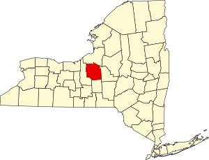
This is a list of the properties and districts listed on the National Register of Historic Places listings in Onondaga County, New York. The locations of National Register properties and districts (at least for all showing latitude and longitude coordinates below) may be seen in a map by clicking on "Map of all coordinates".[1] There are 172 properties and districts listed on the National Register in the county. Of those, 55 are outside Syracuse, and are listed here, while the rest are covered in National Register of Historic Places listings in Syracuse, New York. One property, the New York State Barge Canal, spans the city and the remainder of the county.
This National Park Service list is complete through NPS recent listings posted May 3, 2024.[2]
| Albany (Albany) – Allegany – Bronx – Broome – Cattaraugus – Cayuga – Chautauqua – Chemung – Chenango – Clinton – Columbia – Cortland – Delaware – Dutchess (Poughkeepsie, Rhinebeck) – Erie (Buffalo) – Essex – Franklin – Fulton – Genesee – Greene – Hamilton – Herkimer – Jefferson – Kings – Lewis – Livingston – Madison – Monroe (Rochester) – Montgomery – Nassau – New York (Below 14th Street, 14th to 59th Streets, 59th to 110th Streets, Above 110th Street, Islands) – Niagara (Niagara Falls) – Oneida – Onondaga (Syracuse) – Ontario – Orange – Orleans – Oswego – Otsego – Putnam – Queens – Rensselaer – Richmond – Rockland – St. Lawrence – Saratoga – Schenectady – Schoharie – Schuyler – Seneca – Steuben – Suffolk – Sullivan – Tioga – Tompkins – Ulster – Warren – Washington – Wayne – Westchester (Northern, Southern, New Rochelle, Peekskill, Yonkers) – Wyoming – Yates |
Current listings
Syracuse
Remainder of county
| [3] | Name on the Register | Image | Date listed[4] | Location | City or town | Description |
|---|---|---|---|---|---|---|
| 1 | Alvord House |  | August 27, 1976 (#76001257) | Fred Sehr Park, North of Syracuse on Berwick Road 43°05′19″N 76°08′01″W / 43.088611°N 76.133611°W / 43.088611; -76.133611 (Alvord House) | Salina | Stone farmhouse of Alvord family, merchants in the salt manufacturing business of the Salina area in the early 19th century.[5] |
| 2 | Baldwinsville Village Hall |  | May 9, 1997 (#97000421) | 16 W. Genesee St. 43°09′32″N 76°20′03″W / 43.158889°N 76.334167°W / 43.158889; -76.334167 (Baldwinsville Village Hall) | Baldwinsville | |
| 3 | Borodino District School #8 |  | January 4, 2007 (#06001206) | 1845 Rose Hill Rd. 42°51′40″N 76°20′16″W / 42.861111°N 76.337778°W / 42.861111; -76.337778 (Borodino District School #8) | Borodino | |
| 4 | Borodino Hall |  | July 28, 2006 (#06000647) | 1861 E. Lake Rd. 42°51′31″N 76°20′20″W / 42.858611°N 76.338889°W / 42.858611; -76.338889 (Borodino Hall) | Borodino | |
| 5 | Dan Bradley House |  | December 12, 1978 (#78001889) | 59 South St. 42°58′35″N 76°20′24″W / 42.976389°N 76.34°W / 42.976389; -76.34 (Dan Bradley House) | Marcellus | |
| 6 | Brook Farm | Upload image | December 18, 2003 (#03001304) | 2870 W. Lake Rd. 42°54′58″N 76°25′47″W / 42.916111°N 76.429722°W / 42.916111; -76.429722 (Brook Farm) | Skaneateles | |
| 7 | Camillus Cutlery Company Headquarters |  | August 28, 2018 (#100002836) | 54 W Genesee St. 43°02′20″N 76°18′31″W / 43.0390°N 76.3087°W / 43.0390; -76.3087 (Camillus Cutlery Company Headquarters) | Camillus Village | Well-preserved 1925 daylight factory built for company that relocated upstate from New York City. |
| 8 | Camillus Union Free School |  | May 28, 1991 (#91000628) | Jct. of First and LeRoy Sts. 43°02′26″N 76°18′21″W / 43.040556°N 76.305833°W / 43.040556; -76.305833 (Camillus Union Free School) | Camillus Village | |
| 9 | Carley Onondaga Site | Upload image | January 10, 2011 (#10001127) | Address Restricted | Pompey | |
| 10 | Christ Church and Manlius Village Cemeteries |  | January 25, 2007 (#06001298) | East Seneca St. 43°00′09″N 75°58′12″W / 43.0025°N 75.97°W / 43.0025; -75.97 (Christ Church and Manlius Village Cemeteries) | Manlius | |
| 11 | Church of the Good Shepherd |  | May 8, 1997 (#97000113) | NY 11A, south of its junction with Webster Rd., on the Onondaga Reservation 42°56′42″N 76°09′43″W / 42.945°N 76.161944°W / 42.945; -76.161944 (Church of the Good Shepherd) | Onondaga Indian Reservation | |
| 12 | Community Place |  | April 20, 1979 (#79001611) | S of Skaneateles at 725 Sheldon Rd. 42°58′58″N 76°27′17″W / 42.982778°N 76.454722°W / 42.982778; -76.454722 (Community Place) | Skaneateles | |
| 13 | Mrs. I. L. Crego House |  | June 27, 2007 (#07000631) | 7979 Crego Rd. 43°09′21″N 76°21′13″W / 43.155833°N 76.353611°W / 43.155833; -76.353611 (Mrs. I. L. Crego House) | Baldwinsville | |
| 14 | Delphi Baptist Church | 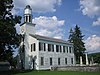 | August 24, 1979 (#79001610) | Oran-Delphi Rd. 42°52′38″N 75°54′48″W / 42.877222°N 75.913333°W / 42.877222; -75.913333 (Delphi Baptist Church) | Delphi Falls | |
| 15 | Delphi Village School |  | May 22, 1986 (#86001152) | East Rd. 42°52′31″N 75°54′54″W / 42.875278°N 75.915°W / 42.875278; -75.915 (Delphi Village School) | Delphi Falls | |
| 16 | Drover's Tavern |  | April 18, 2003 (#03000265) | 4065 Pompey Hollow Rd. 42°58′04″N 75°54′57″W / 42.967778°N 75.915833°W / 42.967778; -75.915833 (Drover's Tavern) | Oran | |
| 17 | Elbridge Hydraulic Industry Archeological District | Upload image | June 15, 1982 (#82003391) | Address Restricted | Elbridge | |
| 18 | Elbridge Village Historic District |  | January 24, 2002 (#01001494) | Roughly along NY 5 bet. Skaneatetes Creek and Carpenter's Brook 43°02′06″N 76°26′49″W / 43.035°N 76.446944°W / 43.035; -76.446944 (Elbridge Village Historic District) | Elbridge | |
| 19 | Charles Estabrook Mansion |  | April 26, 1996 (#96000487) | 7262 E. Genesee St. 43°01′42″N 76°01′16″W / 43.028333°N 76.021111°W / 43.028333; -76.021111 (Charles Estabrook Mansion) | Fayetteville | |
| 20 | Fabius Village Historic District |  | November 22, 2000 (#00001409) | Roughly bounded by N. West St., Mill St., Keeney St., and Fabius Town Line 42°50′05″N 75°59′12″W / 42.8347°N 75.9867°W / 42.8347; -75.9867 (Fabius Village Historic District) | Fabius | |
| 21 | First Baptist Church of Camillus | 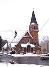 | June 8, 2001 (#01000573) | 23 Genesee St. 43°02′19″N 76°18′29″W / 43.0386°N 76.3081°W / 43.0386; -76.3081 (First Baptist Church of Camillus) | Camillus Village | |
| 22 | James and Lydia Canning Fuller House | 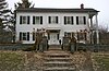 | July 3, 2003 (#03000595) | W. Genesee St. 42°56′41″N 76°26′22″W / 42.9447°N 76.4394°W / 42.9447; -76.4394 (James and Lydia Canning Fuller House) | Skaneateles | |
| 23 | Genesee Street Hill-Limestone Plaza Historic District |  | July 29, 1982 (#82003392) | Roughly both sides of Genesee St., from Chapel St. to Limestone Plaza 43°01′46″N 76°00′36″W / 43.0294°N 76.01°W / 43.0294; -76.01 (Genesee Street Hill-Limestone Plaza Historic District) | Fayetteville | |
| 24 | Lucius Gleason House |  | May 10, 1990 (#90000693) | 314 Second St. 43°06′13″N 76°12′37″W / 43.1036°N 76.2103°W / 43.1036; -76.2103 (Lucius Gleason House) | Liverpool | |
| 25 | Hazelhurst | 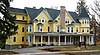 | May 28, 2010 (#10000302) | 150 E. Genesee St. 42°56′39″N 76°25′08″W / 42.9442°N 76.4189°W / 42.9442; -76.4189 (Hazelhurst) | Skaneateles | |
| 26 | Gen. Orrin Hutchinson House | 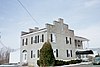 | April 13, 1973 (#73001233) | 4311 W. Seneca Tpke. 42°59′41″N 76°12′57″W / 42.9947°N 76.2158°W / 42.9947; -76.2158 (Gen. Orrin Hutchinson House) | Onondaga | |
| 27 | Indian Castle Village Site | Upload image | January 10, 2011 (#10001126) | Address Restricted | Manlius | |
| 28 | Dr. John Ives House |  | August 29, 1985 (#85001938) | 6575 E. Seneca Turnpike 42°59′27″N 76°04′04″W / 42.9908°N 76.0678°W / 42.9908; -76.0678 (Dr. John Ives House) | Jamesville | |
| 29 | Jordan Village Historic District |  | September 15, 1983 (#83001753) | Roughly bounded by N. Main, S. Main, Elbridge, Clinton, Hamilton, Lawrence, and Mechanic Sts. 43°03′55″N 76°28′25″W / 43.0653°N 76.4736°W / 43.0653; -76.4736 (Jordan Village Historic District) | Jordan | |
| 30 | Kelsey-Davey Farm |  | April 16, 1980 (#80004277) | NE of Skaneateles on Old Seneca Tpke. 42°59′01″N 76°23′23″W / 42.9836°N 76.3897°W / 42.9836; -76.3897 (Kelsey-Davey Farm) | Skaneateles | |
| 31 | Lakeview Cemetery |  | March 13, 2017 (#100000755) | W. Genesee St. near Kane Ave. 42°56′38″N 76°26′24″W / 42.9440°N 76.4401°W / 42.9440; -76.4401 (Lakeview Cemetery) | Skaneateles | 19th century public cemetery that took in earlier burial grounds and includes one of the few extant Cass Gilbert buildings outside New York City |
| 32 | Liverpool Cemetery |  | May 26, 2015 (#15000267) | 225 6th St. 43°06′33″N 76°12′35″W / 43.1093°N 76.20963°W / 43.1093; -76.20963 (Liverpool Cemetery) | Liverpool | Mid-19th century cemetery is final resting place of many residents, particularly immigrants |
| 33 | Manlius Village Historic District |  | November 6, 1973 (#73001232) | Pleasant, Franklin, North, Clinton, and E. Seneca Sts. 43°00′11″N 75°58′31″W / 43.0031°N 75.9753°W / 43.0031; -75.9753 (Manlius Village Historic District) | Manlius | |
| 34 | Martisco Station |  | April 5, 2007 (#07000292) | Martisco Rd., N of Lyons Rd. 43°01′02″N 76°20′09″W / 43.0172°N 76.3358°W / 43.0172; -76.3358 (Martisco Station) | Martisco | |
| 35 | Mottville Cemetery |  | April 22, 2021 (#100006476) | 4275 Jordan Rd. 42°58′41″N 76°26′40″W / 42.9780°N 76.4444°W / 42.9780; -76.4444 (Mottville Cemetery) | Skaneateles | Cemetery |
| 35 | Mycenae Schoolhouse |  | August 11, 1983 (#83001754) | NY 5 43°02′48″N 75°56′01″W / 43.0467°N 75.9336°W / 43.0467; -75.9336 (Mycenae Schoolhouse) | Manlius | |
| 36 | New York State Barge Canal |  | October 15, 2014 (#14000860) | Linear across county 43°09′21″N 76°20′01″W / 43.1559°N 76.3336°W / 43.1559; -76.3336 (New York State Barge Canal) | Baldwinsville, Cicero, Clay, Elbridge, Geddes, Liverpool, Lysander, Salina, Van Buren | Successor to Erie Canal approved by state voters in early 20th century to compete with railroads. |
| 37 | Nine Mile Creek Aqueduct |  | May 17, 1976 (#76001256) | NE of Camillus on Thompson Rd. 43°03′32″N 76°17′09″W / 43.0589°N 76.2858°W / 43.0589; -76.2858 (Nine Mile Creek Aqueduct) | Camillus | |
| 38 | Oran Community Church |  | January 24, 2002 (#01001503) | 8560 Cazenovia Rd, NY 92 42°58′44″N 75°56′09″W / 42.9789°N 75.9358°W / 42.9789; -75.9358 (Oran Community Church) | Pompey | |
| 39 | Oran District No. 22 Schoolhouse |  | August 6, 1998 (#98001002) | Jct. of NY 92 and Delphi Rd. 42°58′43″N 75°56′06″W / 42.9786°N 75.935°W / 42.9786; -75.935 (Oran District No. 22 Schoolhouse) | Oran, in Pompey | |
| 40 | Oswego-Oneida Streets Historic District |  | July 29, 1982 (#82003390) | Oswego, East and West Sts., and Sunset Terr. 43°09′41″N 76°20′08″W / 43.1614°N 76.3356°W / 43.1614; -76.3356 (Oswego-Oneida Streets Historic District) | Baldwinsville | |
| 41 | Pompey Centre District No. 10 Schoolhouse |  | August 6, 1998 (#98001007) | 8354 US 20 42°55′25″N 75°56′58″W / 42.923611°N 75.949444°W / 42.923611; -75.949444 (Pompey Centre District No. 10 Schoolhouse) | Pompey Center, in Pompey | |
| 42 | Robinson Site (AO67-02-0001) | Upload image | March 28, 1985 (#85000660) | Address Restricted | Brewerton | |
| 43 | Saint Mark's Church |  | March 9, 1997 (#97000114) | 6492 E. Seneca Trnpk. 42°59′28″N 76°04′21″W / 42.991111°N 76.0725°W / 42.991111; -76.0725 (Saint Mark's Church) | Jamesville | |
| 44 | Shepard Family Houses |  | December 22, 2015 (#15000923) | 28 W. Genesee & 6 Hannum Sts. 42°56′44″N 76°25′55″W / 42.945498°N 76.432049°W / 42.945498; -76.432049 (Shepard Family Houses) | Skaneateles | Houses of prominent local family, built 1848 and 1901 respectively, and carriage house which is now a bakery. |
| 45 | Shepard Settlement Cemetery |  | November 29, 2010 (#10000938) | Stump & Foster Rds 42°59′42″N 76°23′40″W / 42.9951°N 76.3945°W / 42.9951; -76.3945 (Shepard Settlement Cemetery) | Shepard Settlement | |
| 46 | Skaneateles Historic District |  | May 10, 1984 (#84002818) | Jordan, Fennell, E. and W. Genesee Sts. 42°57′14″N 76°25′36″W / 42.953889°N 76.426667°W / 42.953889; -76.426667 (Skaneateles Historic District) | Skaneateles | |
| 47 | Reuel E. Smith House |  | July 27, 1979 (#79001612) | 28 W. Lake St. 42°56′31″N 76°26′05″W / 42.941944°N 76.434722°W / 42.941944; -76.434722 (Reuel E. Smith House) | Skaneateles | Designed by Alexander Jackson Davis |
| 48 | Levi Snell House |  | August 20, 1987 (#87001365) | 416 Brooklea Dr. 43°02′05″N 76°00′30″W / 43.034722°N 76.008333°W / 43.034722; -76.008333 (Levi Snell House) | Fayetteville | |
| 49 | Solvay Public Library | 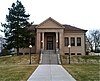 | October 31, 2007 (#07001124) | 615 Woods Rd. 43°03′27″N 76°12′26″W / 43.0575°N 76.207222°W / 43.0575; -76.207222 (Solvay Public Library) | Solvay | |
| 50 | Southwood Two-Teacher School |  | April 6, 2000 (#00000349) | 4621 Barker Hill Rd. 42°59′42″N 76°06′34″W / 42.995°N 76.109444°W / 42.995; -76.109444 (Southwood Two-Teacher School) | Jamesville | |
| 51 | Stone Arabia School |  | April 12, 2007 (#07000289) | 6453 NY 31 43°10′39″N 76°04′31″W / 43.1775°N 76.075278°W / 43.1775; -76.075278 (Stone Arabia School) | Cicero | |
| 52 | Tefft-Steadman House |  | October 31, 2007 (#07001125) | 18 North St. 42°59′18″N 76°20′23″W / 42.988333°N 76.339722°W / 42.988333; -76.339722 (Tefft-Steadman House) | Marcellus | |
| 53 | Whig Hill and Dependencies |  | May 12, 1975 (#75001217) | E. of Plainville at jct. of W. Genesee and Gates Rds. 43°09′33″N 76°26′01″W / 43.159167°N 76.433611°W / 43.159167; -76.433611 (Whig Hill and Dependencies) | Plainville | |
| 54 | Wilcox Octagon House |  | July 28, 1983 (#83001756) | 5420 W. Genesee St. 43°02′28″N 76°16′42″W / 43.041111°N 76.278333°W / 43.041111; -76.278333 (Wilcox Octagon House) | Camillus |
See also
Wikimedia Commons has media related to National Register of Historic Places in Onondaga County, New York.
- National Register of Historic Places listings in New York
- List of National Historic Landmarks in New York
References
- ^ The latitude and longitude information provided in this table was derived originally from the National Register Information System, which has been found to be fairly accurate for about 99% of listings. Some locations in this table may have been corrected to current GPS standards.
- ^ National Park Service, United States Department of the Interior, "National Register of Historic Places: Weekly List Actions", retrieved May 3, 2024.
- ^ Numbers represent an alphabetical ordering by significant words. Various colorings, defined here, differentiate National Historic Landmarks and historic districts from other NRHP buildings, structures, sites or objects.
- ^ The eight-digit number below each date is the number assigned to each location in the National Register Information System database, which can be viewed by clicking the number.
- ^ Cornelia E. Brooke (September 3, 1975). "National Register of Historic Places Registration: Alvord House". New York State Office of Parks, Recreation and Historic Preservation. Retrieved 2008-08-03. Note: Accompanying this are: "Accompanying two photos, from 1974". and "Accompanying nomination correspondence".
External links
- A list of the above sites, with street addresses and other information, is available at Onondaga County, NY listing of National Register of Historic Places.Com, a private site serving up NRHP information.
- The Greek Revival in Syracuse is an online book of Greek Revival architecture in Syracuse.
- v
- t
- e
U.S. National Register of Historic Places in New York

by county
- Albany
- Allegany
- Bronx
- Broome
- Cattaraugus
- Cayuga
- Chautauqua
- Chemung
- Chenango
- Clinton
- Columbia
- Cortland
- Delaware
- Dutchess
- Erie
- Essex
- Franklin
- Fulton
- Genesee
- Greene
- Hamilton
- Herkimer
- Jefferson
- Kings (Brooklyn)
- Lewis
- Livingston
- Madison
- Monroe
- Montgomery
- Nassau
- New York (Manhattan)
- Niagara
- Oneida
- Onondaga
- Ontario
- Orange
- Orleans
- Oswego
- Otsego
- Putnam
- Queens
- Rensselaer
- Richmond (Staten Island)
- Rockland
- Saratoga
- Schenectady
- Schoharie
- Schuyler
- Seneca
- St. Lawrence
- Steuben
- Suffolk
- Sullivan
- Tioga
- Tompkins
- Ulster
- Warren
- Washington
- Wayne
- Westchester
- Wyoming
- Yates
by city
 Category
 List
List National Register of Historic Places Portal


