Mount Olivet, Marshall County, West Virginia
Unincorporated community in West Virginia
40°01′09″N 80°41′42″W / 40.01917°N 80.69500°W / 40.01917; -80.69500 United States
 West Virginia
 Marshall
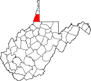
Mount Olivet is an unincorporated community in Marshall County, West Virginia, United States. Mount Olivet is 2 miles (3.2 km) south of Bethlehem.
References
- ^ U.S. Geological Survey Geographic Names Information System: Mount Olivet, Marshall County, West Virginia
- v
- t
- e
Municipalities and communities of Marshall County, West Virginia, United States
County seat: Moundsville
- Benwood
- Cameron
- Glen Dale
- McMechen
- Moundsville
- Wheeling‡
communities
- Adaline
- Allendale
- Alley Grove
- Andersonville
- Bannen
- Bellton
- Big Run
- Calis
- Captina
- Clouston
- Cresap
- Dallas
- Denver Heights
- Fairview
- Georgetown
- Glen Easton
- Golden
- Kausooth
- Kent
- Knoxville
- Limestone
- Lynn Camp
- Majorsville
- McKeefrey
- Millsboro
- Mount Olivet
- Mozart‡
- Natrium
- New Vrindaban
- Pleasant Valley
- Rocklick
- Rosbys Rock
- Saint Joseph
- Sand Hill
- Sherrard
- Viola
- Wolf Run
- Woodlands
- Woodruff
‡This populated place also has portions in an adjacent county or counties
- West Virginia portal
- United States portal
 | This article about a location in Marshall County, West Virginia is a stub. You can help Wikipedia by expanding it. |
- v
- t
- e


