Little Cacapon Mountain
Mountain in West Virginia, United States
39°21′00″N 78°36′37″W / 39.3500986°N 78.6102908°W / 39.3500986; -78.6102908[1]Little Cacapon Mountain (locally /kəˈkeɪpən/ kə-KAY-pən or locally /ˈkeɪpən/ KAY-pən) is a mountain ridge of the Ridge-and-valley Appalachians in Hampshire County, West Virginia, United States. The mountain takes its name from the Little Cacapon River, a Potomac River tributary that lies on its western flanks. Little Cacapon Mountain reaches its highest point of 1,575 feet (480 m) in the vicinity of Barnes Mill. It spans from the Frenchburg area, where it is joined by Chestnut Oak Ridge, to the Slanesville Pike where Crooked Run forms a gap between Little Cacapon Mountain and Queens Ridge near Higginsville.
Gallery
-
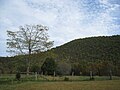 Little Cacapon Mountain viewed from Ginevan Cemetery near Little Cacapon
 -
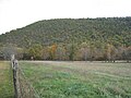 Little Cacapon Mountain viewed from Ginevan Cemetery near Little Cacapon
 -
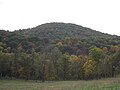 Little Cacapon Mountain viewed from Ginevan Cemetery near Little Cacapon


References
- ^ "Little Cacapon Mountain". Geographic Names Information System. United States Geological Survey, United States Department of the Interior. Retrieved 2009-01-19.
External links
![]() Media related to Little Cacapon Mountain at Wikimedia Commons
Media related to Little Cacapon Mountain at Wikimedia Commons
- v
- t
- e
- Allegheny Mountain
- Back Allegheny Mountain
- Bald Knob
- Barton Knob
- Cheat Mountain
- Droop Mountain
- Elleber Ridge
- Gaudineer Knob
- Knobly Mountain
- Laurel Mountain
- Mount Porte Crayon
- North Fork Mountain
- North Mountain
- Peters Mountain
- River Knobs
- Reddish Knob
- Shavers Fork Mountain Complex
- Shavers Mountain
- Shenandoah Mountain
- Sleepy Creek Mountain
- Snowshoe Mountain
- Spring Gap Mountain
- Spruce Knob
- Spruce Mountain
- Thorny Flat
- White Top
- Blue Ridge Mountain
- Raven Rocks
Appalachians
- Baker Mountain
- Bear Garden Mountain
- Big Schloss
- Cacapon Mountain
- Castle Mountain (Hampshire County)
- Castle Mountain (Pendleton County)
- Cooper Mountain
- Great North Mountain
- High Knob
- Horsepen Mountain
- Keeney Knob
- Little Cacapon Mountain
- Mill Creek Mountain
- Nathaniel Mountain
- New Creek Mountain
- North River Mountain
- Patterson Creek Mountain
- Saddle Mountain
- Schaffenaker Mountain
- Short Mountain
- South Branch Mountain
- Third Hill Mountain
- Bickett Knob
- Bickle Knob
- Black Mountain
- Black Rock
- Buffalo Bull Knob
- Burner Mountain
- Caesar Mountain
- Calders Peak
- Camp Hill
- Close Mountain
- Cottle Knob
- Day Mountain
- Dorsey Knob
- Evick Knob
- Greenwood Mountain
- Gregg Knob
- Gunstock Knob
- Gwinn Mountain
- Honsocker Knob
- Hump Mountain
- Ice Mountain
- Limestone Mountain
- Michael Mountain
- Paddy Knob
- Pifer Mountain
- Pinnickinnick Mountain
- See All
- Sewell Mountain
- Socrates Mountain
- Tallery Mountain
- Twin Sugars
- Ugly Mountain
- Viney Mountain
- Weaver Knob
 | This article is about a location in Hampshire County, West Virginia is a stub. You can help Wikipedia by expanding it. |
- v
- t
- e


