Listed buildings in Sheffield S2
The S2 district lies within the City of Sheffield, South Yorkshire, England. The district contains 69 listed buildings that are recorded in the National Heritage List for England. Of these, four are listed at Grade II*, the middle grade, and the others are at Grade II, the lowest grade. The district is in the east of the city of Sheffield, and covers the areas of Arbourthorne, Highfield, Hyde Park, Manor, Norfolk Park, Park Hill, Wybourn and part of Heeley.
For neighbouring areas, see listed buildings in Sheffield City Centre, listed buildings in S4, listed buildings in S7, listed buildings in S8, listed buildings in S9, listed buildings in S12, listed buildings in S13 and listed buildings in S14.
Key
Map all coordinates using OpenStreetMap
Download coordinates as:
- KML
- GPX (all coordinates)
- GPX (primary coordinates)
- GPX (secondary coordinates)
| Grade | Criteria[1] |
|---|---|
| II* | Particularly important buildings of more than special interest |
| II | Buildings of national importance and special interest |
Buildings
| Name and location | Street | Photograph | Date | Notes | Grade |
|---|---|---|---|---|---|
| Sheffield Manor Ruins 53°22′27″N 1°26′12″W / 53.37422°N 1.43662°W / 53.37422; -1.43662 (MANOR HOUSE (REMAINS)) | Manor Lane | 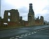 | About 1510 | II | |
| Sheffield Manor Turret House 53°22′26″N 1°26′17″W / 53.37386°N 1.43797°W / 53.37386; -1.43797 (TURRET HOUSE 150 METRES WEST OF MANOR HOUSE RUINS) | Manor Lane |  | About 1574 | II* | |
| Heeley Cruck Barn 53°21′39″N 1°28′11″W / 53.36078°N 1.46960°W / 53.36078; -1.46960 (CRUCK FRAMED BARN) | Wilson Place |  | About 1600 | II | |
| The Albion 53°22′16″N 1°28′38″W / 53.37117°N 1.47711°W / 53.37117; -1.47711 (THE ALBION PUBLIC HOUSE) | London Road | 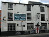 | Late 18th century | II | |
| Ruin east of Sheffield Manor 53°22′27″N 1°26′07″W / 53.37420°N 1.43530°W / 53.37420; -1.43530 (DETACHED RUIN 50 METRES EAST OF MANOR HOUSE) | Manor Lane | Late 18th century | II | ||
| 11–17 St Barnabas Road 53°22′02″N 1°28′29″W / 53.36716°N 1.47474°W / 53.36716; -1.47474 (ROUNDABOUT HOSTEL AND ATTACHED BOUNDARY WALL) | St Barnabas Road |  | Late 18th century | II | |
| Sheaf House 53°22′03″N 1°28′15″W / 53.36759°N 1.47071°W / 53.36759; -1.47071 (SHEAF HOUSE PUBLIC HOUSE) | Bramall Lane |  | About 1800 | II | |
| White Lion 53°21′36″N 1°28′24″W / 53.36006°N 1.47344°W / 53.36006; -1.47344 (THE WHITE LION PUBLIC HOUSE) | London Road |  | About 1800 | II | |
| Shrewsbury Hospital 53°22′38″N 1°27′25″W / 53.37733°N 1.45689°W / 53.37733; -1.45689 (SHREWSBURY HOSPITAL ALMSHOUSES, CHAPEL, CHAPLAINS HOUSE, INFIRMARY AND WALL) | Norfolk Road | 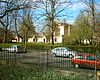 | 1825 | Designed by Woodhead and Hurst | II |
| Shrewsbury Hospital Lodges and Gateways 53°22′39″N 1°27′24″W / 53.37761°N 1.45668°W / 53.37761; -1.45668 (PAIR OF LODGES AND GATEWAYS AT REAR OF SHREWSBURY HOSPITAL ALMSHOUSES) | Norfolk Road | 1825 | Designed by Woodhead and Hurst | II | |
| Heeley Institute 53°21′38″N 1°28′07″W / 53.36061°N 1.46860°W / 53.36061; -1.46860 (FORMER WESLEYAN METHODIST CHAPEL) | Gleadless Road |  | 1826 | II | |
| Beech Hill 53°22′17″N 1°27′28″W / 53.37146°N 1.45778°W / 53.37146; -1.45778 (BEECH HILL WITH ATTACHED COACH HOUSE AND STABLE COURTYARD) | Norfolk Park Road |  | About 1830 | Designed by Woodhead & Hirst | II |
| St Mary's 53°22′21″N 1°28′18″W / 53.37245°N 1.47168°W / 53.37245; -1.47168 (CHURCH OF ST MARY) | Bramall Lane |  | 1830 | Designed by Joseph and Robert Potter | II* |
| Cholera Monument 53°22′33″N 1°27′33″W / 53.37578°N 1.45921°W / 53.37578; -1.45921 (Cholera Monument) | Norfolk Road |  | 1835 | Designed by Matthew Ellison Hadfield | II |
| St John the Evangelist 53°23′02″N 1°27′14″W / 53.38385°N 1.45388°W / 53.38385; -1.45388 (CHURCH OF ST JOHN THE EVANGELIST) | Bernard Road |  | 1838 | Designed by Matthew Ellison Hadfield | II |
| Queen's Tower 53°22′06″N 1°27′26″W / 53.36820°N 1.45722°W / 53.36820; -1.45722 (QUEENS TOWER) | Park Grange Road | 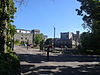 | 1839 | II | |
| Queen's Tower Lodge and Walls 53°22′06″N 1°27′35″W / 53.36826°N 1.45973°W / 53.36826; -1.45973 (FORMER LODGE AND SCREEN WALLS TO QUEENS TOWER) | East Bank Road |  | 1839 | II | |
| Queen's Tower Service Wing and Cottage 53°22′07″N 1°27′25″W / 53.36855°N 1.45702°W / 53.36855; -1.45702 (SERVICE WING AND COTTAGE AT QUEENS TOWER) | Park Grange Road | | 1839 | II | |
| Queen's Tower Stable Court 53°22′06″N 1°27′22″W / 53.36840°N 1.45622°W / 53.36840; -1.45622 (SQUASH CLUB, FORMER STABLE COURT TO EAST OF QUEENS TOWER) | Park Grange Road | | 1839 | II | |
| Queen's Tower Terrace Wall, Gateway and Stair 53°22′05″N 1°27′26″W / 53.36805°N 1.45731°W / 53.36805; -1.45731 (TERRACE WALL, GATEWAY AND STAIR TO WEST OF QUEENS TOWER) | Park Grange Road | 1839 | II | ||
| Arbourthorne Cottages (NE) 53°22′02″N 1°26′50″W / 53.36722°N 1.44736°W / 53.36722; -1.44736 (ARBOURTHORNE COTTAGES NORTH EAST) | St Aidan's Avenue |  | About 1841 | II | |
| Arbourthorne Cottages (SW) 53°22′01″N 1°26′52″W / 53.36702°N 1.44770°W / 53.36702; -1.44770 (ARBOURTHORNE COTTAGES SOUTH WEST) | St Aidan's Avenue |  | About 1841 | II | |
| Norfolk Park Entrance Lodge 53°22′24″N 1°27′00″W / 53.37328°N 1.44988°W / 53.37328; -1.44988 (ENTRANCE LODGE TO NORFOLK PARK) | Granville Road |  | 1841 | II | |
| Norfolk Park West Lodge 53°22′19″N 1°27′25″W / 53.37197°N 1.45684°W / 53.37197; -1.45684 (WEST LODGE TO NORFOLK PARK) | Norfolk Park Road |  | 1841 | II | |
| Norfolk Park West Lodge Gateway and Wall 53°22′19″N 1°27′26″W / 53.37182°N 1.45711°W / 53.37182; -1.45711 (GATEWAY AND SCREEN WALL AT WEST LODGE TO NORFOLK PARK) | Norfolk Park Road |  | 1841 | II | |
| Christ Church, Heeley 53°21′39″N 1°28′04″W / 53.36072°N 1.46779°W / 53.36072; -1.46779 (CHRIST CHURCH) | Gleadless Road |  | 1848 | Designed by Joseph Mitchell | II |
| Christ Church Wall and Gates 53°21′37″N 1°28′05″W / 53.36034°N 1.46793°W / 53.36034; -1.46793 (BOUNDARY WALL AND GATES TO CHRIST CHURCH) | Gleadless Road |  | 1848 | II | |
| Columbia Place 53°22′32″N 1°27′50″W / 53.37561°N 1.46398°W / 53.37561; -1.46398 (COLUMBIA PLACE) | Suffolk Road |  | About 1849 | II | |
| 19 Shrewsbury Road 53°22′37″N 1°27′38″W / 53.37682°N 1.46048°W / 53.37682; -1.46048 (NUMBER 19 AND ATTACHED ENCLOSURE WALL) | Shrewsbury Road | 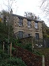 | About 1850 | II | |
| Wharf House 53°23′03″N 1°27′37″W / 53.38421°N 1.46016°W / 53.38421; -1.46016 (12 AND 13, WHARF STREET) | Wharf Street | 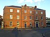 | About 1850 | II | |
| John Shortridge Memorial 53°21′38″N 1°28′04″W / 53.36042°N 1.46764°W / 53.36042; -1.46764 (MEMORIAL TO JOHN SHORTRIDGE 15 METRES SOUTH WEST OF CHRIST CHURCH) | Gleadless Road |  | 1869 | Within Christ Church graveyard | II |
| Lowfield School 53°21′52″N 1°28′20″W / 53.36451°N 1.47216°W / 53.36451; -1.47216 (LOWFIELD JUNIOR AND INFANT SCHOOLS AND ATTACHED CARETAKERS HOUSE) | London Road |  | 1874 | Designed by Innocent and Brown | II |
| Lowfield School Walls, Railings and Gates 53°21′50″N 1°28′20″W / 53.36402°N 1.47221°W / 53.36402; -1.47221 (BOUNDARY WALLS, RAILINGS AND GATES TO LOWFIELD JUNIOR AND INFANT SCHOOLS) | London Road |  | 1874 | Designed by Innocent and Brown | II |
| Kenilworth Works 53°22′16″N 1°28′32″W / 53.37099°N 1.47547°W / 53.37099; -1.47547 (KENILWORTH WORKS) | Boston Street |  | Late 19th century | II | |
| Murray Building 53°22′19″N 1°28′29″W / 53.37199°N 1.47471°W / 53.37199; -1.47471 (MURRAY BUILDING) | Boston Street |  | Late 19th century | II | |
| Nunnery Station Horses Sick Bay 53°23′07″N 1°27′00″W / 53.38521°N 1.45012°W / 53.38521; -1.45012 (Horses sick bay at Nunnery Goods Station (station not included)) | Bernard Road |  | Late 19th century | II | |
| Sewer Gas Lamp 53°22′07″N 1°28′34″W / 53.36873°N 1.47610°W / 53.36873; -1.47610 (SEWER GAS LAMP AT JUNCTION WITH LONDON ROAD) | Alderson Road |  | Late 19th century | At junction with London Road | II |
| Sewer Gas Lamp 53°22′10″N 1°28′06″W / 53.36938°N 1.46826°W / 53.36938; -1.46826 (SEWER GAS LAMP NORTH OF JUNCTION WITH CHERRY STREET) | Lancing Road |  | Late 19th century | At junction with Cherry Street | II |
| Wardonia Works 53°22′18″N 1°28′16″W / 53.37163°N 1.47115°W / 53.37163; -1.47115 (WARDONIA WORKS) | Clough Road |  | Late 19th century | II | |
| Highfield Library 53°22′01″N 1°28′29″W / 53.36690°N 1.47468°W / 53.36690; -1.47468 (HIGHFIELD LIBRARY AND ADJOINING LIBRARIANS HOUSE) | London Road | 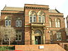 | 1876 | Designed by E. Mitchell Gibbs | II |
| Lamp Standard 53°22′25″N 1°27′01″W / 53.37354°N 1.45018°W / 53.37354; -1.45018 (LAMP STANDARD AT ENTRANCE TO NORFOLK PARK) | Granville Road |  | About 1876 | At entrance to Norfolk Park | II |
| Manor Lodge School 53°22′23″N 1°26′36″W / 53.37313°N 1.44337°W / 53.37313; -1.44337 (MANOR LODGE SCHOOL ADJOINING CARETAKERS HOUSE AND BOUNDARY WALL) | City Road | 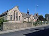 | 1876 | Designed by Innocent and Brown | II |
| Norfolk Park Gateway and Walls 53°22′24″N 1°27′01″W / 53.37332°N 1.45016°W / 53.37332; -1.45016 (GATEWAY AND SCREEN WALLS AT ENTRANCE TO NORFOLK PARK) | Granville Road | | About 1876 | II | |
| St Barnabas House 53°22′00″N 1°28′27″W / 53.36675°N 1.47428°W / 53.36675; -1.47428 (ST BARNABAS HOUSE) | Highfield Place |  | 1876 | Designed by Flockton & Abbot | II |
| Lowfield School Rear Range 53°21′52″N 1°28′18″W / 53.36441°N 1.47172°W / 53.36441; -1.47172 (REAR RANGE TO LOWERFIELD JUNIOR AND INFANT SCHOOLS) | London Road |  | 1877 | Designed by Innocent and Brown | II |
| Portland Works 53°22′12″N 1°28′27″W / 53.36995°N 1.47415°W / 53.36995; -1.47415 (PORTLAND WORKS) | Randall Street | 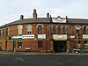 | 1877 | II* | |
| Edmund Road Drill Hall Bollards and Kerb 53°22′20″N 1°28′02″W / 53.37216°N 1.46713°W / 53.37216; -1.46713 (BOLLARDS AND KERB OUTSIDE ENTRANCE TO FORMER DRILL HALL) | Edmund Road |  | 1878 | II | |
| City Road Cemetery Gatehouse, Offices and Walls 53°22′10″N 1°26′28″W / 53.36938°N 1.44100°W / 53.36938; -1.44100 (GATEHOUSE OFFICES LODGES AND SCREEN WALLS AT CITY ROAD CEMETERY) | City Road |  | 1879 | Designed by Matthew Hadfield and Son | II |
| Edmund Road Drill Hall 53°22′19″N 1°28′02″W / 53.37186°N 1.46723°W / 53.37186; -1.46723 (EDMUND ROAD DRILL HALL) | Edmund Road | 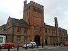 | 1879 | Designed by Matthew Ellison Hadfield | II |
| Highfield Trinity Church 53°21′59″N 1°28′27″W / 53.36628°N 1.47409°W / 53.36628; -1.47409 (HIGHFIELD TRINITY ANGLICAN AND METHODIST CHURCH AND BOUNDARY WALL) | London Road |  | 1879 | Designed by John Dodsley Webster | II |
| Heeley Bank Community Centre and School 53°21′42″N 1°27′47″W / 53.36175°N 1.46308°W / 53.36175; -1.46308 (HEELEY BANK COMMUNITY CENTRE AND ADJOINING INFANT SCHOOL) | Heeley Bank Road | 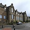 | 1880 | Designed by Edward Robert Robson | II |
| Heeley Bank Community Centre Wall, Railing and Gates 53°21′42″N 1°27′48″W / 53.36177°N 1.46329°W / 53.36177; -1.46329 (BOUNDARY WALL RAILING AND GATES AT HEELEY BANK COMMUNITY CENTRE) | Heeley Bank Road |  | 1880 | Designed by Edward Robert Robson | II |
| Stag Works 53°22′14″N 1°28′27″W / 53.37047°N 1.47414°W / 53.37047; -1.47414 (STAG WORKS) | John Street |  | About 1880 | II | |
| City Road Cemetery Crematorium and Chapels 53°22′08″N 1°26′22″W / 53.36898°N 1.43949°W / 53.36898; -1.43949 (CREMATORIUM AND ADJOINING CHAPELS AT CITY ROAD CEMETERY) | City Road |  | 1881 | Designed by Matthew Hadfield and Son | II |
| City Road Cemetery North West Lodge, Gateway and Wall 53°22′21″N 1°26′18″W / 53.37237°N 1.43829°W / 53.37237; -1.43829 (NORTH WEST LODGE GATEWAY AND BOUNDARY WALL AT CITY ROAD CEMETERY) | City Road |  | 1881 | Designed by Matthew Hadfield and Son | II |
| Anns Road Schools 53°21′41″N 1°28′07″W / 53.36143°N 1.46868°W / 53.36143; -1.46868 (ANNS ROAD NURSERY JUNIOR AND INFANT SCHOOLS CARETAKERS HOUSE AND WALLS) | Anns Road | 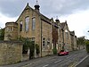 | 1890 | Designed by C. J. Innocent | II |
| Nunnery Station Boundary Wall and Gateway 53°23′07″N 1°27′01″W / 53.38532°N 1.45025°W / 53.38532; -1.45025 (STABLES BOUNDARY WALL AND GATEWAY AT NUNNERY GOODS STATION (NOT INCLUDED)) | Bernard Road | About 1890 | II | ||
| Chinese Christian Church 53°21′42″N 1°28′10″W / 53.36157°N 1.46932°W / 53.36157; -1.46932 (ST ANDREWS METHODIST CHURCH AND SUNDAY SCHOOL WITH STEPS AND WALL) | Anns Road |  | 1896 | II | |
| Victoria Methodist Church 53°22′33″N 1°27′07″W / 53.37594°N 1.45208°W / 53.37594; -1.45208 (Victoria Methodist Church and adjoining Sunday school) | Stafford Road |  | 1899 | II | |
| Victoria Methodist Church Wall, Gates and Railing 53°22′33″N 1°27′08″W / 53.37584°N 1.45234°W / 53.37584; -1.45234 (BOUNDARY WALL, GATES AND RAILING TO VICTORIA METHODIST CHURCH) | Stafford Road | | 1899 | II | |
| City Road Cemetery Roman Catholic Chapel 53°22′17″N 1°26′13″W / 53.37150°N 1.43698°W / 53.37150; -1.43698 (ROMAN CATHOLIC MORTUARY CHAPEL AT CITY ROAD CEMETERY) | City Road |  | 1900 | Designed by Charles Hadfield | II |
| Former Sheffield Savings Bank 53°21′50″N 1°28′18″W / 53.36393°N 1.47177°W / 53.36393; -1.47177 (TRUSTEE SAVINGS BANK) | Queens Road |  | 1900 | II | |
| Wesley House 53°21′59″N 1°28′26″W / 53.36643°N 1.47395°W / 53.36643; -1.47395 (WESLEY HOUSE AND BOUNDARY RAILINGS) | Highfield Place |  | 1906 | II | |
| Belgian War Memorial 53°22′18″N 1°26′14″W / 53.37155°N 1.43716°W / 53.37155; -1.43716 (BELGIAN WAR MEMORIAL AT CITY ROAD CEMETERY) | City Road |  | About 1920 | Within City Road Cemetery | II |
| City Road Cemetery War Memorial 53°22′11″N 1°26′20″W / 53.36971°N 1.43880°W / 53.36971; -1.43880 (WAR MEMORIAL 80 METRES NORTH EAST OF CREMATORIUM AT CITY ROAD CEMETERY) | City Road |  | About 1920 | Designed by Reginald Blomfield | II |
| St Aidan and St Luke 53°22′20″N 1°26′38″W / 53.37232°N 1.44380°W / 53.37232; -1.44380 (CHURCH OF ST AIDAN AND ST LUKE) | City Road |  | 1933 | Designed by Flockton & Son | II |
| St Aidan and St Luke Wall and Gate Piers 53°22′21″N 1°26′39″W / 53.37247°N 1.44415°W / 53.37247; -1.44415 (BOUNDARY WALL AND GATE PIERS TO CHURCH OF ST AIDAN AND ST LUKE) | City Road | | 1933 | Designed by Flockton & Son | II |
| City Road Cemetery Blitz Grave 53°22′09″N 1°26′09″W / 53.36914°N 1.43591°W / 53.36914; -1.43591 (THE BLITZ GRAVE 200 METRES EAST OF THE CREMATORIUM AT CITY ROAD CEMETERY) | City Road | 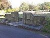 | About 1941 | II | |
| Park Hill Flats 53°22′46″N 1°27′34″W / 53.37946°N 1.45933°W / 53.37946; -1.45933 (PARK HILL) | Duke Street |  | 1961 | Designed by Jack Lynn and Ivor Smith | II* |
References
- [1] – A list of all the listed buildings within Sheffield City Council's boundary is available to download from this page.
Sources
- Historic England. "Listed Buildings". Retrieved 1 August 2022.
- v
- t
- e
- Abbeydale Industrial Hamlet Housing
- Arts Tower and Library
- Beauchief Abbey
- Beauchief Hall
- Beehive Works
- Bishops' House
- Botanical Gardens Glasshouses
- Broom Hall
- Butchers Wheel
- City Hall
- Cornish Place
- Cutlers' Hall
- Darnall Works
- Ecclesfield Priory
- Endcliffe Hall
- Fair House Farmhouse
- General Cemetery
- Globe Works
- Green Lane Works Gateway
- Heritage House
- King Edward VII Upper School
- Leah's Yard
- Little Matlock Rolling Mill
- Loxley United Reformed Church
- Lyceum Theatre
- Manor Lodge Turret House
- Mappin Art Gallery
- The Mount
- Mount Pleasant
- Norton Hall
- Oakes Park
- Old Hall Farmhouse
- Old Queen's Head
- Onesacre Hall
- Paradise Square
- Park Hill Flats
- St James, Midhopestones
- St James, Norton
- St John, Ranmoor
- St Mary, Bramall Lane
- St Mary the Virgin, Beighton
- St Paul, Wordsworth Avenue
- Sharrow Mills
- Victoria Quays Terminal Warehouse
- War Memorial
- Well Meadow Street Crucible Furnace
- Whitley Hall Hotel
- Wicker Arches


