Kiglapait Mountains

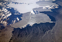
The Kiglapait Mountains lie north of Nain, in northern Labrador, south of the Torngat and Kaumajet Mountains. Not as high as those ranges, they still boast very rugged terrain and many peaks with high prominence values. The name means "dog-tooth."
| Rank | Name | m | ft |
|---|---|---|---|
| 1 | Man O'War Peak | 1050 | 3445 |
| 2 | Peak 3400 (14E/2) | 1036+ | 3400+ |
| 3 | Peak 3300 (14E/1) | 1006+ | 3300+ |
| 4 | Peak 3300 (14E/2) | 1006+ | 3300+ |
| 5 | Peak 3200 (14E/1) | 975+ | 3200 |
| 6 | Peak 3100 (14E/1) | 945+ | 3100+ |
| 7 | Peak 3000#1 (14D/16) | 914+ | 3000+ |
| 8 | Aupalukitak Mountain | 914+ | 3000+ |
| 9 | Mount Thoresby | 914+ | 3000+ |
| 10 | Peak 3000#2 (14D/16) | 914+ | 3000+ |
External links
- "Kiglapait Mountains 2500-foot Peaks". Peakbagger.com.
- Photo gallery, Aerial photos of Kiglapait Mountains by Doc Searls
57°06′00″N 61°34′57″W / 57.10000°N 61.58250°W / 57.10000; -61.58250
- v
- t
- e
Mountains of Newfoundland and Labrador
- Bishop's Mitre
- Brave Mountain
- Cod Island
- Anguille Mountains
- The Cabox
- Gros Morne
- Lewis Hills
- Mount Musgrave
- Pic a Tenerife
| Selamiut Range | |
|---|---|
| Others |
- Annieopsquotch Mountains
- Kiglapait Mountains
- Mealy Mountains
- Mount Sylvester
- Peter Snout
 | This Labrador location article is a stub. You can help Wikipedia by expanding it. |
- v
- t
- e


