Khashtarak
40°56′19″N 45°10′47″E / 40.93861°N 45.17972°E / 40.93861; 45.17972
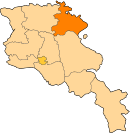
Place in Tavush, Armenia
Khashtarak Խաշթառակ | |
|---|---|
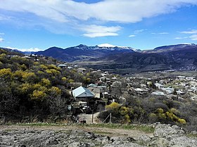
 A view of Khashtarak and surrounding nature | |
  Khashtarak  Khashtarak | |
| Coordinates: 40°56′19″N 45°10′47″E / 40.93861°N 45.17972°E / 40.93861; 45.17972 | |
| Country | Armenia |
| Province | Tavush |
| Municipality | Ijevan |
| Population (2011)[1] | |
| • Total | 1,771 |
| Time zone | UTC+4 (AMT) |
| Khashtarak at GEOnet Names Server | |
Khashtarak (Armenian: Խաշթառակ) is a village in the Ijevan Municipality of the Tavush Province of Armenia. Within the village is a recently built church, and close by, to the west and the southeast of the village are some abandoned medieval settlements with khachkars.
Education and health care
There have been several charitable activities organized by the Armenia Fund in Khashtarak in recent times. The medical center of the village, the kindergarten and the public-education school were all renovated by the efforts of diaspora Armenians.
Gallery
-
 A view of Khashtarak
 -
 St. David Church in Khashtarak
 -
 Houses in Khashtarak
 -
 One of the three cross-symbols of Khashtarak
 -
 A view of Khashtarak and surrounding nature
 -
 A view of Khashtarak
 -
 Landscape around Khashtarak
 -
 WWII monument in Khashtarak


References
- ^ Statistical Committee of Armenia. "The results of the 2011 Population Census of Armenia" (PDF).
External links
Wikimedia Commons has media related to Khashtarak.
- Report of the results of the 2001 Armenian Census, Statistical Committee of Armenia
- v
- t
- e
 Tavush Province
Capital: Ijevan
Portal:
 Geography


