Kangasniemi
Municipality in Southern Savonia, Finland

Coat of arms

Location of Kangasniemi in Finland
 Finland
 (2018-01-01)[1]
(2023-12-31)[2]
Kangasniemi is a municipality in the Southern Savonia region, Finland. The municipality has a population of 5,114 (31 December 2023)[2] and covers an area of 1,326.75 square kilometres (512.26 sq mi) of which 256.86 km2 (99.17 sq mi) is water.[1] The population density is 4.78 inhabitants per square kilometre (12.4/sq mi).
Kangasniemi is located on the Finnish national road 13, 50 km (31 mi) northwest of Mikkeli and 63 km (39 mi) southeast of Jyväskylä. Distance to the national capital, Helsinki is 250 km (160 mi). Its neighbour municipalities are Hankasalmi, Hirvensalmi, Joutsa, Mikkeli, Pieksämäki and Toivakka.
There are almost 3600 (May 2014) summer houses, and summer guests redouble the number of inhabitants during the summer months.
The municipality is unilingually Finnish.
History
The municipality was founded in 1867.
Nature
There are more than 1,550 kilometres (960 mi) of shoreline. The largest lakes are Puulavesi and Kyyvesi. Some other lakes are Mallos and Synsiä. In 1997, Kangasniemi was voted the most beautiful municipality in Finland by television show.[citation needed]
Economy
Kangasniemi has large forest resources, approximately 12,000,000 cubic metres (420,000,000 cu ft), and the yearly growth is approximately 500,000 m3 (18,000,000 cu ft). There is also Puula golf field.[citation needed]
Famous natives
- Emilie Björkstén, poet
- Hilding Ekelund, architect
- Otto Manninen, writer, poet and translator
- Tepa Reinikainen, shot putter
- Hiski Salomaa, singer and songwriter
- Virpi Sarasvuo, née Kuitunen, cross-country skier
- Sami Sarjula, actor
- Martti Tolamo, athlete
Gallery
-
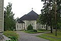 Church
 -
 Läsäkoski canal
 -
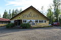 Syvälahden lava


See also
References
- ^ a b "Area of Finnish Municipalities 1.1.2018" (PDF). National Land Survey of Finland. Retrieved 30 January 2018.
- ^ a b c "Population growth biggest in nearly 70 years". Population structure. Statistics Finland. 26 April 2024. ISSN 1797-5395. Retrieved 29 April 2024.
- ^ "Population according to age (1-year) and sex by area and the regional division of each statistical reference year, 2003–2020". StatFin. Statistics Finland. Retrieved 2 May 2021.
- ^ a b "Luettelo kuntien ja seurakuntien tuloveroprosenteista vuonna 2023". Tax Administration of Finland. 14 November 2022. Retrieved 7 May 2023.
External links
![]() Media related to Kangasniemi at Wikimedia Commons
Media related to Kangasniemi at Wikimedia Commons ![]() Kangasniemi travel guide from Wikivoyage
Kangasniemi travel guide from Wikivoyage
- Municipality of Kangasniemi – Official website
- The Finnish Association for Persons with Intellectual Disabilities Official website
Places adjacent to Kangasniemi | ||||||||||||||||
|---|---|---|---|---|---|---|---|---|---|---|---|---|---|---|---|---|
| ||||||||||||||||


- v
- t
- e

| Authority control databases: Geographic |
|
|---|
 | This Eastern Finland location article is a stub. You can help Wikipedia by expanding it. |
- v
- t
- e


