Hokkaido Koma-ga-take
Andesitic stratovolcano on the island of Hokkaido
You can help expand this article with text translated from the corresponding article in Japanese. Click [show] for important translation instructions.
- Machine translation, like DeepL or Google Translate, is a useful starting point for translations, but translators must revise errors as necessary and confirm that the translation is accurate, rather than simply copy-pasting machine-translated text into the English Wikipedia.
- Consider adding a topic to this template: there are already 3,614 articles in the main category, and specifying
|topic=will aid in categorization. - Do not translate text that appears unreliable or low-quality. If possible, verify the text with references provided in the foreign-language article.
- You must provide copyright attribution in the edit summary accompanying your translation by providing an interlanguage link to the source of your translation. A model attribution edit summary is
Content in this edit is translated from the existing Japanese Wikipedia article at [[:ja:北海道駒ヶ岳]]; see its history for attribution. - You may also add the template
{{Translated|ja|北海道駒ヶ岳}}to the talk page. - For more guidance, see Wikipedia:Translation.


Mount Hokkaidō-Komagatake
Hokkaidō, Japan
50000:1 室蘭
Hokkaidō Koma-ga-take (北海道駒ヶ岳, Hokkaidō Koma-ga-take), also Oshima Koma-ga-take (渡島駒ヶ岳), Oshima Fuji (渡島富士), or just Koma-ga-take (駒ヶ岳) is a 1,131 metres (3,711 ft) andesitic stratovolcano[1] on the border between Mori, Shikabe, and Nanae, all within the Oshima Subprefecture of Hokkaidō, Japan.
Occurrence of volcanic activity started some 30,000 years ago. Following roughly 5,000 years of dormancy, volcanic activity at Mount Koma-ga-take restarted in 1640,[2] triggering the Kan'ei Great Famine.[citation needed] Since then, there have been at least 50 recorded volcanic events at Mount Koma-ga-take.[3]
-
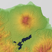 Relief Map
 -
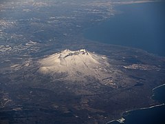
 Viewed from NW.
 -
 Viewed from ESE.


See also
- Komagatake
References
- ^ "HOKKAIDO KOMA-GA-TAKE". Quaternary Volcanoes of Japan. Geological Survey of Japan, AIST. 2006. Archived from the original on 2012-12-19. Retrieved 2009-06-22.
- ^ Takahashi, Ryo (March 2022). "Mineralogical and geochemical investigations for subvolcanic hydrothermal alteration environments at an active volcano: An example of Hokkaido-Komagatake volcano, Japan". Journal of Volcanology and Geothermal Research. 423. Bibcode:2022JVGR..42307497T. doi:10.1016/j.jvolgeores.2022.107497. S2CID 246616567. Retrieved January 10, 2024.
- ^ 神沼克伊,小山悦郎 日本の火山を科学する 日本列島津々浦々、あなたの身近にある108の活火山とは? ソフトバンククリエイティブ 2011. ISBN 978-4797361308.
- Geographical Survey Institute
- Teikoku's Complete Atlas of Japan, Teikoku Shoin Co., Ltd., Tokyo 1990, ISBN 4-8071-0004-1
External links
 Media related to Mount Hokkaido-Koma at Wikimedia Commons
- Hokkaido-Komagatake - Japan Meteorological Agency (in Japanese)
- "Hokkaido-Komagatake: National catalogue of the active volcanoes in Japan" (PDF). - Japan Meteorological Agency
- Hokkaido-Komagatake Volcano - Geological Survey of Japan
- Hokkaido-Komagatake - Smithsonian Institution: Global Volcanism Program
Authority control databases | |
|---|---|
| National |
|
| Geographic |
|
- v
- t
- e


