Hamilton Lea
Human settlement in England
- Hamilton Lea
- Charnwood
- Leicestershire
- East Midlands
- Charnwood
- List of places
- UK
- England
- Leicestershire
Hamilton Lea is a village and civil parish on the edge of Leicester, Leicestershire, England.[1][2]
Geography
Hamilton Lea is a part of the more recent Hamilton development, which spilled over the Leicester city boundary into the Borough of Charnwood around Catteric Way and the northern stretches of Laverton Road and Hackness Road.[3]
At 9.689 km² or 3.74 square miles, Hamilton Lea is the smallest inhabited civil parish in the United Kingdom by area, and the second smallest overall, after Chester Castle.[4]
Demographics
In the 2021 census, the Hamilton Lea had 1,168 inhabitants. The majority of residents, at 58%, were from a South Asian background, followed by 28% from a White background and the remainder were Black, Arab or mixed race. Hinduism was the most practiced religion in Hamilton Lea with 33% of the population identifying as Hindu. Christians and Muslims each made up 20% of the population followed by Sikhs at 8%, with the remaining 17% identifying as having no religion.[5] In 2021, the parish has 248 dwellings. [6] The population density was 120.5 people per km².
Governance
Hamilton Lea is part Charnwood Borough Council's South Charnwood Villages ward[7] and Leicestershire County Council's Thurmaston Ridgemere electoral division.
The Hamilton Lea civil parish was formed on 1 April 2019, from part of the Barkby Thorpe civil parish. As of 2024, Hamilton Lea has not established a parish council and holds an annual parish meeting, which all registered electors can attend.[8]
Gallery
-
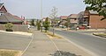 Laverton Road
 -
 Hamilton Lea under construction
 -
 Hamilton Lane forms the eastern boundary of the parish
 -
 Public Footpath to the abandoned historic village of Hamilton


References
- ^ "Hamilton Lea (Parish, United Kingdom) - Population Statistics, Charts, Map and Location". www.citypopulation.de. Archived from the original on 20 July 2021. Retrieved 20 July 2021.
- ^ "Local government and public involvement in Health Act 2007" (PDF). 31 July 2018. Archived (PDF) from the original on 20 July 2021. Retrieved 20 July 2021.
- ^ "Hamilton Lea - MapIt". Mapit.mysociety.org. Archived from the original on 20 July 2021. Retrieved 20 July 2021.
- ^ "Standard Area Measurements (2020) for Parishes and Non-Civil Parished Areas in England and Wales". Office for National Statistics. Retrieved 18 August 2023.
- ^ "Hamilton Lea (Parish, United Kingdom) - Population Statistics, Charts, Map and Location". www.citypopulation.de. Archived from the original on 20 July 2021. Retrieved 20 July 2021.
- ^ https://democracy.leics.gov.uk/documents/s170276/Annual%20Report%20202021.pdf
- ^ https://www.lgbce.org.uk/sites/default/files/2023-04/charnwood_it_so_0.pdf
- ^ "First Hamilton Lea parish meeting - Council news - Communication and news - Charnwood Borough Council". Charnwood.gov.uk. 28 January 2020. Archived from the original on 20 July 2021. Retrieved 20 July 2021.
External links
- Hamilton Lea Parish Meeting
 Media related to Hamilton Lea at Wikimedia Commons


