Hadzhidimovo
Place in Blagoevgrad, Bulgaria
Hadzhidimovo Хаджидимово | |
|---|---|
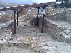 Ruins of an ancient fortress near Hadzhidimovo | |
| 41°31′19″N 23°52′8.4″E / 41.52194°N 23.869000°E / 41.52194; 23.869000 | |
| Country |  Bulgaria Bulgaria |
| Province (Oblast) | Blagoevgrad |
| Government | |
| Area | |
| • Total | 333 km2 (129 sq mi) |
| Elevation | 485 m (1,591 ft) |
| Population | |
| • Total | 4,560 |
| Area code | 07528 |
Hadzhidimovo (Bulgarian: Хаджидимово [xɐˈd͡ʒidimovo]) is a small town and the centre of Hadzhidimovo Municipality in Blagoevgrad Province, south-western Bulgaria.
It is located in the southernmost part of Bulgaria, bordering on Greece in the Chech region.
Geography
The town lies in the Mesta River valley, surrounded by the heights of Rila, Pirin, Slavyanka, Shilka, Bozdag, and the Western Rhodopes Mountains.
Although the town is located in a Mediterranean climate region, temperatures quite often fall below 0 °C in winter, and the summers are hot with temperatures sometimes reaching 45 °C.
History
Hadzhidimovo was formed through the merger of the villages of Gorna Singartia and Dolna Singartia. Throughout the 19th century, researchers listed the two villages as having a predominantly ethnic Bulgarian population with a Turkish minority.[1]
For a while after the merger, the settlement was known as Zhostovo, after Bulgarian general Konstantin Zhostov who was born in nearby Gaytaninovo. Today, it bears the name of leftist Internal Macedonian Revolutionary Organization (IMRO) revolutionary Dimo Hadzhidimov since 1951. Hadzhidimovo was proclaimed a town in 1996.
Transportation
The municipality is crossed by the II-19 highway from Gotse Delchev, Koprivlen, and Sadovo to the Greek border at Ilinden.
References
Wikimedia Commons has media related to Hadzhidimovo.
- ^ Македония и Одринско. Статистика на населението от 1873 г., Македонски научен институт, София, 1995, стр. 126-127.
- Description of Hadzhidimovo on en.journey.bg Archived 2020-09-18 at the Wayback Machine
- Description on www.guide-bulgaria.com
- v
- t
- e
- Sofia (capital)

- Balchik
- Bankya
- Berkovitsa
- Byala Slatina
- Cherven Bryag
- Chirpan
- Elhovo
- Etropole
- Gotse Delchev
- Harmanli
- Ihtiman
- Karnobat
- Kavarna
- Knezha
- Kostinbrod
- Kozloduy
- Mezdra
- Nesebar
- Novi Iskar
- Novi Pazar
- Panagyurishte
- Parvomay
- Pavlikeni
- Peshtera
- Pomorie
- Popovo
- Provadia
- Radnevo
- Radomir
- Rakovski
- Razlog
- Stamboliyski
- Svilengrad
- Aksakovo
- Bansko
- Belene
- Belogradchik
- Beloslav
- Bobov Dol
- Bozhurishte
- Byala, Ruse Province
- Chepelare
- Devin
- Devnya
- Dolni Chiflik
- Dryanovo
- Dulovo
- Elena
- Elin Pelin
- Galabovo
- General Toshevo
- Hisarya
- Isperih
- Kostenets
- Kotel
- Krichim
- Krumovgrad
- Kubrat
- Kuklen
- Levski
- Lukovit
- Lyaskovets
- Lyubimets
- Madan
- Momchilgrad
- Omurtag
- Oryahovo
- Perushtitsa
- Pirdop
- Rakitovo
- Saedinenie
- Septemvri
- Simeonovgrad
- Simitli
- Slivnitsa
- Sopot, Plovdiv Province
- Sredets
- Straldzha
- Svoge
- Tervel
- Teteven
- Topolovgrad
- Tryavna
- Tsarevo
- Tutrakan
- Tvarditsa
- Varshets
- Veliki Preslav
- Yakoruda
- Zlatitsa
- Zlatograd
- Aheloy
- Apriltsi
- Ardino
- Banya
- Batak
- Batanovtsi
- Belitsa
- Belovo
- Borovo
- Bratsigovo
- Bregovo
- Breznik
- Byala
- Chernomorets
- Dalgopol
- Debelets
- Dobrinishte
- Dolna Banya
- Dolna Mitropoliya
- Dolna Oryahovitsa
- Dolni Dabnik
- Dospat
- Dragoman
- Dunavtsi
- Dve Mogili
- Dzhebel
- Glodzhevo
- Godech
- Gulyantsi
- Gurkovo
- Hadzhidimovo
- Ignatievo*
- Iskar
- Ivaylovgrad
- Kableshkovo
- Kalofer
- Kameno
- Kaspichan
- Kilifarevo
- Klisura
- Kocherinovo
- Koprivshtitsa
- Kostandovo
- Koynare
- Kresna
- Kran
- Krivodol
- Kula
- Laki
- Letnitsa
- Loznitsa
- Maglizh
- Malko Tarnovo
- Marten
- Мizia
- Nedelino
- Nikolaevo
- Nikopol
- Obzor
- Opaka
- Pavel Banya
- Polski Trambesh
- Pordim
- Pravets
- Primorsko
- Rila
- Roman
- Rudozem
- Sadovo
- Sapareva Banya
- Sarnitsa
- Shabla
- Shivachevo
- Slavyanovo
- Slivo Pole
- Smyadovo
- Sozopol
- Strazhitsa
- Strelcha
- Sungurlare
- Suvorovo
- Sveti Vlas
- Tran
- Trastenik
- Tsar Kaloyan
- Ugarchin
- Valchedram
- Valchi Dol
- Varbitsa
- Vetovo
- Vetren
- Yablanitsa
- Zavet
- Zlataritsa
- city status after the census of 01.02.2011: Ignatievo, Kran
| ||
|---|---|---|
Capital: Hadzhidimovo | ||
| Villages |  | |
| Landmarks |
| |
| Culture | ||
| Notable people |
| |
Authority control databases | |
|---|---|
| International |
|
| National |
|
41°31′18″N 23°52′8″E / 41.52167°N 23.86889°E / 41.52167; 23.86889
 | This Smolyan Province, Bulgaria location article is a stub. You can help Wikipedia by expanding it. |
- v
- t
- e


