Greny
Part of Petit-Caux in Normandy, France
Location of Greny

49°56′51″N 1°18′25″E / 49.9475°N 1.3069°E / 49.9475; 1.3069
1
(2019)[1]
76630
(avg. 125 m or 410 ft)
Greny is a former commune in the Seine-Maritime department in the Normandy region in northern France. On 1 January 2016, it was merged into the new commune of Petit-Caux.[2]
Geography
A small farming village, Greny is situated in the Pays de Caux, some 9 miles (14 km) east of Dieppe on the D117 road.
Heraldry
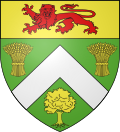 | The arms of Greny are blazoned : Vert, a chevron argent between 2 garbs and a tree, and on a chief Or a leopard gules.
|
Population
| Year | 1962 | 1968 | 1975 | 1982 | 1990 | 1999 | 2006 | 2011 |
|---|---|---|---|---|---|---|---|---|
| Population | 121 | 122 | 124 | 102 | 111 | 105 | 138 | 145 |
| From the year 1962 on: No double counting—residents of multiple communes (e.g. students and military personnel) are counted only once. | ||||||||
Places of interest
- The church of St. Anne, dating from the seventeenth century.
See also
References
Wikimedia Commons has media related to Greny.
Authority control databases | |
|---|---|
| International |
|
| National |
|
| Other |
|
- v
- t
- e


