Grand Wash Cliffs
Landform in Mohave County, Arizona
35°58′59″N 113°58′01″W / 35.983°N 113.967°W / 35.983; -113.967

class=notpageimage|
Foothills of Grand Wash Cliffs, (city-or-landform locations)The Grand Wash Cliffs[1] extend south-southeast from the Grand Canyon-Parashant National Monument in northwest Arizona west of the Shivwits Plateau south through the Grand Cliffs Wilderness and into the Lake Mead Recreation Area. The Grand Wash Cliffs cross the Grand Canyon where the Colorado River enters Lake Mead. To the south of the Grand Canyon the Grand Wash Cliffs continue past the east side of Grapevine Mesa and then southeast above and east of the Hualapai Valley forming the southwest margin of the Music Mountains.[2]
List of landforms/communities along Grand Wash Cliffs
(form north-to-south)
- Grand Wash Cliffs Wilderness (~north terminus) (Loc. dot 1)
- Squaw Canyon
- Pigeon Canyon
- Pearce Canyon
- Pearce Ferry, Lake Mead (at Colorado River)
- Meadview, Arizona (Grapevine Mesa, west, at foothills) (Loc. dot 2)
- Garnet Mountain (Loc. dot 3)
- Music Mountains (part of Hualapai Plateau elevations, east)
- Crozier, Arizona
- Valentine, Arizona (at south terminus) (Loc. dot 4)
- Peacock Mountains
- Cane Springs, Arizona (using Upper Burro Creek Wilderness coord.) (Loc. dot 5)
-
 Sunset at Meadview with Joshua trees
 -
 Cliffs, and foothills with Joshua Trees
 -
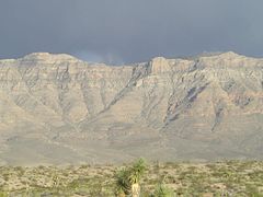
 Grand Wash Cliffs, from Pierce Ferry Road


See also
Wikimedia Commons has media related to Grand Wash Cliffs.
- Hurricane Cliffs
- Aubrey Cliffs
- Aubrey Valley
References
- GNIS data for Grand Wash Cliffs
- GNIS data for Upper Grand Wash Cliffs
- GNIS data for Grand Wash Cliffs Wilderness
External links
- Grand Wash Cliffs Wilderness, AZ at topoquest.com
- Coordinates for Upper Burro Creek Wilderness, for (Cane Springs, Arizona)
Grand Wash Cliffs Wilderness
- Grand Wash Cliffs Wilderness at wilderness.net
Geology/Geography
- Geologic Map of the Peacock Mountains and Southern Grand Wash Cliffs, map Citation [1]
- Grand Wash Basin (north Grand Wash Cliffs), maps & description, for water resources, etc.
- Geology strata (photo & graphic) of Grand Wash Cliffs, at Geologic History of the Lake Mead National Recreation Area, at 3dpark.wr.usgs.gov Archived 2010-05-28 at the Wayback Machine
- v
- t
- e
(Yavapai County)
- Boundary Cone
- Fortification Hill
- Mount Wilson
- Mount Union
- Castle Dome
- Carr Peak
- Miller Peak
- Aubrey Peak
- Hualapai Peak
- Lime Peak
- Mae West Peaks
- Four Peaks
- Mount Ord
- East End
- McDowell Peak
- Mount McDowell
- Thompson Peak
- Mount Ballard (Arizona)
- Camelback Mountain
- Mummy Mountain
- Piestewa Peak
- South Mountains
- Sunnyslope Mountain
- Ibex Peak
- Agassiz Peak
- Doyle Peak
- Fremont Peak
- Mount Bigelow
- Mount Lemmon
- Pusch Ridge
- Thimble Peak
- Mount Hopkins
- Mount Wrightson
- Mount Turnbull
- Mistake Peak
- Granite Mountain
- Black Dome
- Sentinel Peak
- Tumamoc Hill
- Apache Peak
- Black Mesa (Navajo County)
- Escudilla Mountain
- Mount Baldy
- Agathla Peak
- Agua Caliente Mountains
- Agua Dulce Mountains
- Antelope Hill
- Aquarius Mountains
- Artillery Mountains
- Atascosa Mountains
- Aubrey Hills
- Baboquivari Peak
- Balakai Mesa
- Beaver Dam Mountains
- Belmont Mountains
- Bill Williams Mountain
- Bitsihuitsos Butte
- Black Hills (Greenlee County)
- Black Mesa (Apache-Navajo Counties)
- Black Mesa (Warm Springs)
- Black Mountain (Maricopa County)
- Black Mountain (Pima County)
- Blackjack Mountains
- Bryan Mountains
- Buckskin Mountain (Arizona-Utah)
- Buckskin Mountains (La Paz County)
- Bush Head
- Cabeza Prieta Mountains
- Canelo Hills
- Carrizo Mountains
- Cerro Colorado Mountains
- Chocolate Mountains
- Copper Mountains
- Coyote Mountains
- Date Creek Mountains
- Dome Rock Mountains
- Dos Cabezas Mountains
- Etoi Ki
- Excalibur
- Galiuro Mountains
- Gavilan Peak
- Gila Bend Mountains
- Gila Mountains (Graham County)
- Gila Mountains (Yuma County)
- Goldfield Mountains
- Grand Wash Cliffs
- Granite Mountains
- Granite Wash Mountains
- Growler Mountains
- Gu Achi Peak
- Guadalupe Mountains
- Harcuvar Mountains
- Harquahala Mountains
- House Mountain
- Hunts Mesa
- Isis Temple
- John the Baptist Mountains
- Juniper Mesa
- Kaibab Plateau
- Kofa Mountains
- Laguna Mountains
- Las Guijas Mountains
- Lime Mountain (Maricopa County}
- Little Harquahala Mountains
- Little Rincon Mountains
- Lukachukai Mountains
- Madrean Sky Islands
- Mescal Mountains
- Mineral Mountains
- Moccasin Mountains
- Mohave Mountains
- Mohawk Mountains
- Mount Trumbull
- Muggins Mountains
- Mustang Mountains
- Navajo Mountain
- The Needles
- New River Mountains
- New Water Mountains
- Newton Butte
- Painted Rock Mountains
- Pajarito Mountains
- Patagonia Mountains
- Peacock Mountains
- Picacho Peak
- Picketpost Mountain
- Pinnacle Peak
- Poachie Range
- Poston Butte
- Rawhide Mountains
- Sacaton Mountains
- San Luis Mountains
- Santa Maria Mountains
- Sevenmile Mountains
- Sierra San Antonio
- Sierra Estrella
- Sierra Madre Occidental
- Sierra Pinta
- Silver Bell Mountains
- Squaw Tits
- Sugarloaf Mountain
- Sunset Mountains
- Swisshelm Mountains
- Tempe Butte
- Temple Butte
- Tinajas Altas Mountains
- Tordillo Mountain
- Tortolita Mountains
- Trigo Mountains
- Tule Mountains
- Tumacacori Mountains
- Virgin Mountains
- Vulcan's Throne
- Vulture Mountains
- Waterman Mountains
- Weaver Mountains
- West Silver Bell Mountains
- White Tank Mountains
- Wickenburg Mountains
| Authority control databases: National |
|
|---|


