Grade II* listed buildings in Leicester
Map all coordinates using OpenStreetMap
Download coordinates as:
- KML
- GPX (all coordinates)
- GPX (primary coordinates)
- GPX (secondary coordinates)
There are over 20,000 Grade II* listed buildings in England. This page show the list of these buildings in the city of Leicester.
City of Leicester
| Name | Location | Type | Completed [note 1] | Date designated | Grid ref.[note 2] Geo-coordinates | Entry number [note 3] | Image |
|---|---|---|---|---|---|---|---|
| Aylestone Hall | Aylestone, City of Leicester | House | Medieval | 23 February 1955 | SK5743101132 52°36′18″N 1°09′12″W / 52.604945°N 1.153401°W / 52.604945; -1.153401 (Aylestone Hall) | 1361408 | 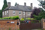 More images |
| Aylestone Old Bridge | Aylestone, City of Leicester | Bridge | 15th century | 23 February 1955 | SK5678900936 52°36′12″N 1°09′46″W / 52.603251°N 1.162914°W / 52.603251; -1.162914 (Aylestone Old Bridge) | 1074055 |  More images |
| Belgrave Hall and railings and gates in front | Belgrave, City of Leicester | House | 1709 | 5 January 1950 | SK5927707216 52°39′34″N 1°07′30″W / 52.659435°N 1.125057°W / 52.659435; -1.125057 (Belgrave Hall and railings and gates in front) | 1074030 | 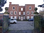 More images |
| Belgrave House, Railings and Piers in Front of Belgrave House | Belgrave, City of Leicester | House | 1776 | 5 January 1950 | SK5924807182 52°39′33″N 1°07′32″W / 52.659132°N 1.125491°W / 52.659132; -1.125491 (Belgrave House, Railings and Piers in Front of Belgrave House) | 1074033 |  More images |
| Leicester Cathedral | City of Leicester | Cathedral | 12th century to 15th century | 5 January 1950 | SK5849804454 52°38′05″N 1°08′13″W / 52.634692°N 1.137061°W / 52.634692; -1.137061 (Leicester Cathedral) | 1183725 | 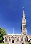 More images |
| Chantry House | City of Leicester | Chantry College | 1511 | 5 January 1950 | SK5834204099 52°37′53″N 1°08′22″W / 52.631518°N 1.139428°W / 52.631518; -1.139428 (Chantry House) | 1074791 | 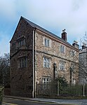 More images |
| Church of All Souls | City of Leicester | Church | 1904 | 14 March 1975 | SK5862303116 52°37′22″N 1°08′08″W / 52.622652°N 1.135451°W / 52.622652; -1.135451 (Church of All Souls) | 1074057 | 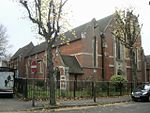 More images |
| Church of St Andrew | Aylestone, City of Leicester | Church | 13th century | 5 January 1950 | SK5718701016 52°36′14″N 1°09′25″W / 52.603928°N 1.157024°W / 52.603928; -1.157024 (Church of St Andrew) | 1074054 |  More images |
| Church of St Andrew and attached Former Schoolroom | City of Leicester | Church | 1860-62 | 14 March 1975 | SK5846303723 52°37′41″N 1°08′16″W / 52.628125°N 1.137707°W / 52.628125; -1.137707 (Church of St Andrew and attached Former Schoolroom) | 1184162 |  More images |
| Church of St James the Greater | City of Leicester | Church | 1895-1901 | 15 January 1988 | SK6002503300 52°37′27″N 1°06′53″W / 52.624153°N 1.11471°W / 52.624153; -1.11471 (Church of St James the Greater) | 1361037 |  More images |
| Church of St John the Baptist | City of Leicester | Church | 1884-1885 | 14 March 1975 | SK6022402621 52°37′05″N 1°06′43″W / 52.618028°N 1.111894°W / 52.618028; -1.111894 (Church of St John the Baptist) | 1074035 |  Upload Photo |
| Church of St Mark | City of Leicester | Church | 1869 to 1872 | 14 March 1975 | SK5905605366 52°38′34″N 1°07′43″W / 52.64283°N 1.128654°W / 52.64283; -1.128654 (Church of St Mark) | 1300759 |  More images |
| Church of St Saviour | City of Leicester | Church | 1875-77 | 14 March 1975 | SK6039004858 52°38′17″N 1°06′33″W / 52.638117°N 1.109034°W / 52.638117; -1.109034 (Church of St Saviour) | 1074774 |  More images |
| Leicester Corn Exchange | City of Leicester | Corn Exchange | 1851 | 5 January 1950 | SK5874804439 52°38′04″N 1°08′00″W / 52.634531°N 1.13337°W / 52.634531; -1.13337 (Leicester Corn Exchange) | 1361417 | 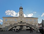 More images |
| Engineering Building, University of Leicester | City of Leicester | Faculty Building | 1961-63 | 30 March 1993 | SK5942302865 52°37′13″N 1°07′25″W / 52.620309°N 1.12368°W / 52.620309; -1.12368 (Engineering Building, University of Leicester) | 1074756 |  More images |
| Gates and Gatepiers North West of War Memorial Onto University Road | Victoria Park, City of Leicester | Gate | 1923 | 14 March 1975 | SK5940503300 52°37′27″N 1°07′26″W / 52.624221°N 1.123868°W / 52.624221; -1.123868 (Gates and Gatepiers North West of War Memorial Onto University Road) | 1361051 | 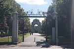 More images |
| HSBC, Granby Street, now ISKCON Leicester | City of Leicester | Bank (financial) | 1872-1874 | 20 August 1972 | SK5888704362 52°38′02″N 1°07′53″W / 52.633823°N 1.13133°W / 52.633823; -1.13133 (HSBC, Granby Street, now ISKCON Leicester) | 1074047 |  More images |
| Inglewood | City of Leicester | House | 1892 | 14 March 1975 | SK6048901836 52°36′39″N 1°06′29″W / 52.610942°N 1.108124°W / 52.610942; -1.108124 (Inglewood) | 1074805 | 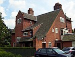 More images |
| Iron Gates in Garden at rear of Skeffington House | City of Leicester | Gate | Early 18th century | 14 March 1975 | SK5834604158 52°37′55″N 1°08′22″W / 52.632048°N 1.139359°W / 52.632048; -1.139359 (Iron Gates in Garden at rear of Skeffington House) | 1074006 |  |
| Lodges and Gates North East of War Memorial | Victoria Park, City of Leicester | Gate | 1923 | 23 February 1955 | SK5973803519 52°37′34″N 1°07′08″W / 52.626153°N 1.11891°W / 52.626153; -1.11891 (Lodges and Gates North East of War Memorial) | 1185461 |  More images |
| Melbourne Hall Free Church and attached Memorial Schools | City of Leicester | Sunday School | 1884 | 13 November 2002 | SK6010403934 52°37′47″N 1°06′48″W / 52.629843°N 1.113428°W / 52.629843; -1.113428 (Melbourne Hall Free Church and attached Memorial Schools) | 1096016 | Upload Photo |
| Monument to Edward Holdsworth at East End of Garden at Belgrave Hall including Statue of Religion | Belgrave, City of Leicester | Statue | 1761 | 14 March 1975 | SK5935707242 52°39′35″N 1°07′26″W / 52.65966°N 1.123869°W / 52.65966; -1.123869 (Monument to Edward Holdsworth at East End of Garden at Belgrave Hall including Statue of Religion) | 1361396 | Upload Photo |
| National Westminster Bank | City of Leicester | Bank (financial) | 1900-1902 | 14 March 1975 | SK5862204409 52°38′03″N 1°08′07″W / 52.634274°N 1.135237°W / 52.634274; -1.135237 (National Westminster Bank) | 1074810 | 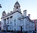 |
| Newarke Houses Museum: Skeffington House | City of Leicester | House | c. 1600 | 5 January 1950 | SK5836304116 52°37′54″N 1°08′21″W / 52.631669°N 1.139115°W / 52.631669; -1.139115 (Newarke Houses Museum: Skeffington House) | 1361423 |  |
| Newarke Wall (along north west end of gardens of Newarke Houses Museum) | City of Leicester | Boundary Wall | c. 1423 | 14 March 1975 | SK5833204154 52°37′55″N 1°08′22″W / 52.632014°N 1.139566°W / 52.632014; -1.139566 (Newarke Wall (along north west end of gardens of Newarke Houses Museum)) | 1361054 |  |
| Old Grammar School | City of Leicester | Grammar School | Built 1573 | 5 January 1950 | SK5836704607 52°38′10″N 1°08′20″W / 52.636082°N 1.138969°W / 52.636082; -1.138969 (Old Grammar School) | 1361426 | 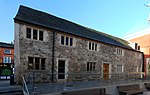 More images |
| Parish Church of St Denys | Evington, City of Leicester | Church | Late 13th century to early-mid 14th century | 5 January 1950 | SK6275902766 52°37′09″N 1°04′28″W / 52.619045°N 1.074429°W / 52.619045; -1.074429 (Parish Church of St Denys) | 1200786 |  More images |
| Parish Church of St Peter | Belgrave, City of Leicester | Church | 12th century | 5 January 1950 | SK5928607156 52°39′32″N 1°07′30″W / 52.658894°N 1.124934°W / 52.658894; -1.124934 (Parish Church of St Peter) | 1074029 |  More images |
| The Gate House, Leicester Castle | City of Leicester | Gatehouse | 1445-59 | 5 January 1950 | SK5826704207 52°37′57″N 1°08′26″W / 52.632497°N 1.140517°W / 52.632497; -1.140517 (The Gate House, Leicester Castle) | 1200573 | 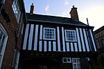 |
| Tomb of Andrew Lord Rollo to the North East of St Margaret's Church | City of Leicester | Tomb | 1765 | 16 May 1995 | SK5857005123 52°38′27″N 1°08′09″W / 52.640698°N 1.135879°W / 52.640698; -1.135879 (Tomb of Andrew Lord Rollo to the North East of St Margaret's Church) | 1250247 |  More images |
| Leicester Town Hall | City of Leicester | Town Hall | 1874-76 | 30 March 1972 | SK5879504319 52°38′00″N 1°07′58″W / 52.633447°N 1.132697°W / 52.633447; -1.132697 (Leicester Town Hall) | 1074780 | 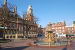 More images |
| Wyggeston House | City of Leicester | House | c. 1500 | 5 January 1950 | SK5839604429 52°38′04″N 1°08′19″W / 52.634479°N 1.138572°W / 52.634479; -1.138572 (Wyggeston House) | 1074008 | 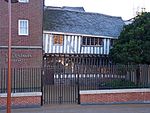 More images |
| 17 Friar Lane | City of Leicester | House | 18th century | 5 January 1950 | SK5859004319 52°38′00″N 1°08′09″W / 52.633469°N 1.135726°W / 52.633469; -1.135726 (17 Friar Lane) | 1183556 | 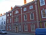 More images |
| 21 St Martins | City of Leicester | House | Early 18th century | 14 March 1975 | SK5856904423 52°38′04″N 1°08′10″W / 52.634406°N 1.136018°W / 52.634406; -1.136018 (21 St Martins) | 1361022 |  More images |
| 1, 2, 3 4–14 The Crescent | City of Leicester | House | c. 1810 | 5 January 1950 | SK5892403857 52°37′45″N 1°07′51″W / 52.62928°N 1.130873°W / 52.62928; -1.130873 (1, 2, 3 4–14 The Crescent) | 1074019 | 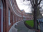 |
See also
Notes
- ^ The date given is the date used by Historic England as significant for the initial building or that of an important part in the structure's description.
- ^ Sometimes known as OSGB36, the grid reference is based on the British national grid reference system used by the Ordnance Survey.
- ^ The "List Entry Number" is a unique number assigned to each listed building and scheduled monument by Historic England.
External links
![]() Media related to Grade II* listed buildings in Leicester at Wikimedia Commons
Media related to Grade II* listed buildings in Leicester at Wikimedia Commons
- v
- t
- e
- Bedfordshire
- Berkshire
- Bristol
- Buckinghamshire
- Cambridgeshire
- Cheshire
- Cornwall
- Cumbria
- Derbyshire
- Devon
- Dorset
- Durham
- East Sussex
- East Riding of Yorkshire
- Essex
- Gloucestershire
- Greater London
- Greater Manchester
- Hampshire
- Herefordshire
- Hertfordshire
- Isle of Wight
- Kent
- Lancashire
- Leicestershire
- Lincolnshire
- Merseyside
- Norfolk
- North Yorkshire
- Northamptonshire
- Northumberland
- Nottinghamshire
- Oxfordshire
- Rutland
- Shropshire
- Somerset
- South Yorkshire
- Staffordshire
- Suffolk
- Surrey
- Tyne and Wear
- Warwickshire
- West Midlands
- West Sussex
- West Yorkshire
- Wiltshire
- Worcestershire
- Allerdale
- Amber Valley
- Ashford
- Babergh
- Barrow-in-Furness
- Basildon
- Basingstoke and Deane
- Bath and North East Somerset
- Bolsover
- Boston
- Bournemouth
- Bradford
- Braintree
- Breckland
- Brentwood
- Brighton and Hove
- Bristol
- Broadland
- Calderdale
- Cambridge
- Camden
- Canterbury
- Carlisle
- Castle Point
- Chelmsford
- Cheltenham
- Cherwell
- Cheshire East
- Cheshire West and Chester
- Chesterfield
- Chiltern
- Christchurch
- Colchester
- Copeland
- Corby
- Cotswold
- Dartford
- Daventry
- Dover
- East Cambridgeshire
- Exeter
- Mendip
- North Somerset
- North Yorkshire (district)
- Poole
- Sedgemoor
- South Somerset
- Stoke-on-Trent
- Taunton Deane
- West Somerset
- York


