Fort Tejon
United States historic place
Fort Tejon | |
California Historical Landmark No. 129[1] | |
 Fort Tejon Barracks | |
| Nearest city | Lebec, California |
|---|---|
| Built | 1854 |
| NRHP reference No. | 71000140 |
| CHISL No. | 129[1] |
| Significant dates | |
| Added to NRHP | 1971 |
| Designated CHISL | 1954 |
Fort Tejon in California is a former United States Army outpost which was intermittently active from June 24, 1854, until September 11, 1864. It is located in the Grapevine Canyon (La Cañada de las Uvas) between the San Emigdio Mountains and Tehachapi Mountains. It is in the area of Tejon Pass along Interstate 5 in Kern County, California, the main route through the mountain ranges separating the Central Valley from the Los Angeles Basin and Southern California. The fort's location protected the San Joaquin Valley from the south and west.
Purpose
The fort's mission was to suppress stock rustling and protect settlers from attacks by discontent Californios (pre-statehood residents), and Native American tribes, including the Paiute and Mojave, and to monitor the less aggressive Emigdiano living nearby. The Emigdiano, who were closely related to the Chumash of the coastal and interior lands to the west, had several villages near Fort Tejon. After the earlier Spanish and Mexican colonial Indian Reductions, they were generally cooperative with the European-American settlers and the U.S. Army.
History

At the urging of Edward Fitzgerald Beale, Superintendent of Indian Affairs in California, the U.S. Army established Fort Tejon in 1854. Fort Tejon was the headquarters of the First U.S. Dragoons until those Regular Army troops were transferred to the East in July 1861 soon after the outbreak of the American Civil War. The fort was re-occupied by California volunteer troops in 1863. Those units included Companies D, E and G of the 2nd California Volunteer Cavalry from July 6 to August 17, 1863; and Company B of the 2nd California Volunteer Infantry, which remained there until Fort Tejon was abandoned for good on September 11, 1864.[2]
The fort lay along the Stockton - Los Angeles Road. From 1858, it was a stagecoach station on the Butterfield Overland Mail, which followed the same route as far as Visalia. From 1858, Fort Tejon was the western terminus of the experimental U.S. Camel Corps, which used imported camels in an effort to carry supplies across arid regions in the Southwest. The soldiers found the camels hardy, but temperamental, and they spooked the horses used by the cavalry.[3]
The great earthquake of 1857, which became known as the Fort Tejon earthquake, was centered nearly 100 miles away. The earthquake became associated with the fort by name because the area near the epicenter was sparsely populated. The most reliable report of the event was issued from the fort, nearly 93 miles (149.7 km) distant.
Fort Tejon State Historic Park
The state historic park is listed on the National Register of Historic Places. In 1940, at the urging of local citizens, the Tejon Ranch Company deeded 5 acres (2.0 ha) to the State of California to established a state park.[4] Its original historic buildings have been documented by the Historic American Buildings Survey. Several buildings have been restored, and two are partially open to visitors. The restored barracks contain display cases of uniforms and a recreated troopers' quarters. The commanding officer's quarters have several restored and furnished rooms. Officers' quarters nearby are only stabilized in a state of arrested decay, with walls buttressed by masonry and lumber and tied together with reinforcing rods.
A quartermaster building has been reconstructed[4] and houses materials used in dragoon life and Civil War reenactments. The sites of former buildings, planned for reconstruction, are marked by split rail fences along the outlines of their foundations. A park office, containing exhibits of dragoon life and restrooms, is at the east end of the parade ground near the parking lot by Interstate 5.
The park grounds include the original barracks, where the soldiers slept, and also the grave site of Peter Lebeck, which is indicated with a historical marker. The nearby town of Lebec is named after him.[5]
Fort Tejon is the site of frequent Civil War reenactments presented by the Fort Tejon Historical Association.[6]
The park contains a number of natural features of interest, including centuries-old valley oaks[7] and California condors.[4]
1857 Fort Tejon earthquake
The Fort Tejon earthquake occurred at about 8:20 AM (Pacific time) on January 9, 1857. It ruptured the San Andreas Fault for a length of about 350 kilometers (220 mi), between Parkfield and San Bernardino. Displacement along the fault was as much as 9 meters (30 feet) in the Carrizo Plain but less along the Palmdale section of the fault, closest to Los Angeles. The amount of fault slip gives this earthquake a moment magnitude of 7.9, comparable to that of the 1906 San Francisco earthquake. Based on the (uncertain) distribution of foreshocks for this earthquake, it is assumed that the beginning of the fault rupture (the epicenter) was in the area between Parkfield and Cholame, about 60 miles northwest. Nevertheless, it is usually called the "Fort Tejon" earthquake because this was the location of the greatest damage, most of the area being unpopulated at the time.
See also
- Fort Tejon Historical Association
- California Historical Landmarks in Kern County
- California Historical Landmark
References
- ^ "Fort Tejon". Office of Historic Preservation, California State Parks. Retrieved 2012-10-07.
- ^ "2nd California Volunteer Cavalry", Civil War Archive Website, accessed 11-11-08
- ^ Slatta, Richard W. (2001). The mythical West : an encyclopedia of legend, lore, and popular culture. Santa Barbara, Calif.: ABC-CLIO. ISBN 9781576071519. OCLC 50174716.
- ^ a b c "Fort Tejon State Historic Park" (PDF). California State Parks. Retrieved 8 January 2022.
- ^ "Peter Lebeck", Historical Marker Database
- ^ Fort Tejon State Historic Park pamphlet, State of California, Department of Parks & Recreation, Sacramento, California, 1991.
- ^ "Fort Tejon State Historic Park". California Department of Parks and Recreation. Retrieved 8 January 2022.
-
 East end of the restored barracks building. The unreconstructed kitchen/mess hall is outlined by split rail fence to the left.
 -
 Barracks interior showing soldiers' quarters.
 -
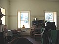 The day room in the barracks.
 -
 Uniform items on display in the day room.
 -
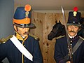 One of the several uniform displays in the barracks.
 -
 Model of Dragoon in the barracks.
 -
 View of the barracks from the front porch of the commanding officer's quarters. The split rail fence at the near end of the barracks denotes the foundation outline of another barracks yet to be reconstructed.
 -
 The quartermaster building.
 -
 The interior of the quartermaster building showing materials used during Dragoon and Civil War reenactments staged at Fort Tejon.
 -
 The restored commanding officer's quarters.
 -
 A furnished room inside the commanding officer's quarters.
 -
 The dining room inside the commanding officer's quarters.
 -
 Bedroom for the children and servant on the second floor of the commanding officer's quarters.
 -
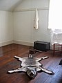 Wolf rug in the adults' bedroom on the second floor of the commanding officer's quarters.
 -
 The roof of the commanding officer's quarters receiving new shingles, showing the detail of roof construction.
 -
 Officers' quarters. This building has been stabilized but not restored, and is not open to the public. The interiors may be viewed through the wire fencing.
 -
 Detail showing the interior wall bracing needed to stabilize the structure of the officers' quarters.
 -
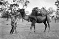 Army Camel Corp training
 -
 Army Camel Corp monument


External links
Wikimedia Commons has media related to
Fort Tejon State Historic Park.
Fort Tejon State Historic Park.
- Official Fort Tejon State Historic Park website
- The Fort Tejon Historical Association
- Historic American Buildings Survey (HABS) No. CA-39, "Fort Tejon, Highway 99, Lebec vicinity, Kern County, CA"
- HABS No. CA-39-A, "Fort Tejon, Barracks Number One"
- HABS No. CA-39-B, "Fort Tejon, Barracks Number Two"
- HABS No. CA-39-C, "Fort Tejon, Officers' Quarters"
- HABS No. CA-39-D, "Fort Tejon, Soldiers' Quarters"
- HABS No. CA-39-E, "Fort Tejon, Smokehouse"
34°52′26″N 118°53′39″W / 34.874000°N 118.89430°W / 34.874000; -118.89430
- v
- t
- e
Butterfield Overland Mail 1st Division Stations
- San Francisco – Western terminus and 1st Division headquarters, located in downtown San Francisco.
- Clarks's Station – Located 12 miles south of San Francisco in what is now San Bruno.
- Sun Water Station – Located 9 miles south of Clarks Station in what is now San Mateo.
- Redwood City – Located 9 miles south of Sun Water Station.
- Mountain View Station – Located 12 miles south of Redwood City.
- San Jose Station – Located 11 miles south of Mountain View Station in the city of San Jose.
- Seventeen Mile House – Located 17 miles south of San Jose.
- Gilroy Station – Located 13 miles south of Seventeen Mile House in what is now Gilroy, California.
- Pacheco Pass Station – Located 18 miles east of Gilroy near the top of Pacheco Pass.
- St. Louis Ranch – Located 17 miles east of Pacheco Pass.
- Lone Willow Station – Located 18 miles east of St. Louis Ranch near Los Banos.
- Temple's Ranch – Located 13 miles southeast of Lone Willow Station near Dos Palos.
- Firebaugh's Ferry – Located 15 miles southeast of Temples Ranch, on the San Joaquin River.
- Fresno City – Located 19 miles southeast of Firebaugh's Ferry.
- Elkhorn Spring Station – Located 22 miles east of Fresno City near present-day Riverdale.
- Whitmore's Ferry – Located 17 miles southeast of Elkhorn Spring Station on the Kings River.
- Head of Cross Creek Station – Located 15 miles southeast of Whitmore's Ferry.
- Visalia – Located 12 miles southeast of Cross Creek Station.
- Packwood Station – Located 12 miles east of Visalia.
- Tule River Station – Located 14 miles south of Packwood Station.
- Fountain Spring Station – Located 14 miles southeast of Tule River Station.
- Mountain House – Located 12 miles south of Fountain Spring Station.
- Posey Creek Station – Located 15 miles southwest of Mountain House, on Posey (Poso) Creek.
- Gordon's Ferry (Kern River Station) – Located 10 miles south of Posey Creek Station on the Kern River just above present-day Bakersfield.
- Kern River Slough Station – Located 12 miles south of Gordons Ferry.
- Sink of Tejon Station – Located 14 miles southwest of Kern River Slough Station.
- Fort Tejon – Located 15 miles southwest of Sink of Tejon Station, north of and below the summit of Tejon Pass.
- Reed's Station – Located 8 miles southeast of Fort Tejon, near, to the south of the summit of the Tejon Pass.
- French John's Station – Located 14 miles east southeast of Reeds Station, in the vicinity of the mouth of Cow Springs Creek Canyon.
- Mud Spring, a later station operating in 1860, 14 miles east from French Johns and 13 miles north from Clayton's Station (formerly Widow Smith's Station). [1]
- Widow Smith's Station (Clayton's Station, Major Gordon's Station) – Located 24 miles from French John's Station, in upper San Francisquito Canyon near Green Valley.
- King's Station – Located 10 miles south of Widow Smith's Station in lower San Francisquito Canyon.
- Hart's Station or Lyons Station – Located 12 miles south of King's Station, in Santa Clarita.
- Lopez Station – Located 81⁄2 miles southeast of Hart's Station, in the San Fernando Valley north of Mission San Fernando Rey de España.
- Cahuenga Station – Located 12 miles southeast of Mission San Fernando, in Cahuenga Pass, of the Santa Monica Mountains. The first station of the 1st Division, it was located 12 miles northwest of Los Angeles.
Source: "List of Butterfield Overland Mail Stations "Itinerary of the Route"" (PDF). New York Times. October 14, 1858.
- [1] Notes of a Trip to Los Angeles No. 1, Daily Alta California, Volume 12, Number 3888, 5 October 1860 — Page 1

| |
|---|---|
| Topics | |
| Lists by state |
|
| Lists by insular areas | |
| Lists by associated state | |
| Other areas | |
| Related | |
| |


