Euberta, New South Wales
Town in New South Wales, Australia
35°04′S 147°13′E / 35.067°S 147.217°E / -35.067; 147.217- 478 km (297 mi) from Sydney
- 20 km (12 mi) from Wagga Wagga
- 9 km (6 mi) from Malebo
- 6 km (4 mi) from Millwood[2]
Euberta is a farming community in the central Riverina area of New South Wales. It is situated on the old Narrandera road with Millwood 6 kilometres to its west and Malebo 9 kilometres to its east. At the 2021 census, Euberta had a population of 130 people.[1] The area is made up of rich pastoral close to the Murrumbidgee River giving graziers the ability to use central pivot and other irrigation systems to grow crops such as Lucerne.
Gallery
-
 Centre Pivot Irrigation at Euberta
 -
 Centre Pivot Irrigation (close up)
 -
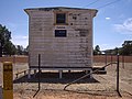
 Homestead at Euberta


-
 Euberta Telephone Exchange

Notes and references
- ^ a b Australian Bureau of Statistics (28 June 2022). "Euberta (State Suburb)". 2021 Census QuickStats. Retrieved 18 March 2023.

- ^ Travelmate Archived 24 March 2007 at the Wayback Machine[dead link]
Wikimedia Commons has media related to Euberta, New South Wales.
- v
- t
- e

Communities
- Adelong
- Adjungbilly
- Alfredtown
- Alma Park
- Ardlethan
- Ariah Park
- Ballbank
- Balldale
- Balranald
- Barellan
- Barham
- Barnes
- Barooga
- Batlow
- Beckom
- Bectric
- Beelbangera
- Beggan Beggan
- Berrigan
- Bethungra
- Bidgeemia
- Bilbul
- Binya
- Birrego
- Blighty
- Book Book
- Bookham
- Booligal
- Booroorban
- Borambola
- Boree Creek
- Bowna
- Brawlin
- Brocklesby
- Brookdale
- Brungle
- Brushwood
- Bulgandry
- Bullenbung
- Bundure
- Bungowannah
- Bunnaloo
- Buraja
- Burraboi
- Burrandana
- Burrinjuck
- Burrumbuttock
- Caldwell
- Carabost
- Carrathool
- Cavan
- Coleambally
- Collingullie
- Colinroobie
- Combaning
- Conargo
- Condoulpe
- Cookardinia
- Coolac
- Coolamon
- Cootamundra
- Coree
- Coreen
- Corobimilla
- Corowa
- Cowabbie
- Culcairn
- Cunninyeuk
- Currawarna
- Darbalara
- Darlington Point
- Daysdale
- Deniliquin
- Dilpurra
- Dirnaseer
- Downside
- Euberta
- Eurongilly
- Euston
- Ferndale
- Finley
- Frampton
- French Park
- Galore
- Ganmain
- Gidginbung
- Gerogery
- Gobarralong
- Gocup
- Gogeldrie
- Goolgowi
- Goorawin
- Grahamstown
- Greenvale
- Grong Grong
- Gulpa
- Gunbar
- Gundagai
- Hanwood
- Harefield
- Hay
- Henty
- Hillston
- Holbrook
- Hopefield
- Howlong
- Humula
- Illabo
- Illilawa
- Jerilderie
- Jindera
- Jingellic
- Jugiong
- Junee
- Junee Reefs
- Kamarah
- Khancoban
- Koraleigh
- Kyalite
- Kyeamba
- Kywong
- Lacmalac
- Ladysmith
- Langtree
- Lankeys Creek
- Laurel Hill
- Leeton
- Little Billabong
- Lockhart
- Logie Brae
- Lowesdale
- Mairjimmy
- Malebo
- Mangoplah
- Mannus
- Marinna
- Marrar
- Mathoura
- Matong
- Maude
- Mayrung
- Merriwagga
- Merungle Hill
- Methul
- Milbrulong
- Millwood
- Mirrool
- Mitta Mitta
- Moama
- Moira
- Moolpa
- Moombooldool
- Morago
- Morundah
- Morven
- Moulamein
- Mullengandra
- Mulwala
- Mundarlo
- Munderoo
- Murrami
- Muttama
- Nangus
- Narraburra
- Narrandera
- Niemur
- Nyora
- Oaklands
- Oberne
- Old Junee
- One Tree
- Osborne
- Oura
- Ournie
- Oxley
- Penarie
- Perekerten
- Pleasant Hills
- Pretty Pine
- Pulletop
- Rand
- Rankins Springs
- Rannock
- Rennie
- Rosewood
- Ryan
- Sandigo
- Sangar
- Savernake
- Sebastopol
- Speewa
- Springdale
- Stanbridge
- Stockinbingal
- Stony Crossing
- Stony Point
- Tabbita
- Table Top
- Talbingo
- Talmalmo
- Talmo
- Tantonan
- Tarcutta
- Temora
- The Rock
- Tocumwal
- Tooleybuc
- Tooma
- Tootool
- Tullakool
- Tumbarumba
- Tumblong
- Tumut
- Tuppal
- Urana
- Urangeline
- Urangeline East
- Uranquinty
- Waddi
- Wakool
- Walbundrie
- Walla Walla
- Wallendbeen
- Walleroobie
- Wamoon
- Wanganella
- Wantabadgery
- Warburn
- Warragoon
- Wee Jasper
- Welaregang
- Westby
- Whitton
- Widgelli
- Widgiewa
- Willbriggie
- Womboota
- Wondalga
- Woodend
- Woolgarlo
- Woomargama
- Wymah
- Yalgogrin South
- Yallakool
- Yanco
- Yenda
- Yerong Creek
- Yoogali
- Yuluma
- Cocoparra
- Lachlan Valley
- Livingstone
- Murray Valley
- Murrumbidgee Valley
- Oolambeyan
- Woomargama
- Yanga
Water and irrigation entities
Other watercourses
- Darling
- Edward
- Goodradigbee
- Lachlan
- Little Murray
- Murray
- Murrumbidgee
- Niemur
- Paddys
- Rufus
- Tooma
- Tumut
- Wakool
- Yass
- Murray Irrigation Area
- Murrumbidgee Irrigation Area
- Murrumbidgee Irrigation
- Riverina Water County Council
- Adelong
- Adjungbilly
- Back
- Barmedman
- Bendy
- Berthong
- Billabong
- Black Joes
- Bland
- Bowning
- Broadway
- Brooks
- Bulls Head
- Bungendore
- Burkes
- Cohen
- Dairy
- Derringullen
- Gum Flat
- Hell Hole
- Little
- Jerra Jerra
- Kindra
- Mannus
- Maragle
- Mirrool
- Mulwala Canal
- Murrumbateman
- Peelwood
- Pugilistic
- Reedy
- Sandy (Mirrool)
- Spring
- Tarcutta
- Taylors
- Tumbarumba
- Yellow Bog


