Donard Forest
54°12′11″N 5°54′07″W / 54.203°N 5.902°W / 54.203; -5.902
Donard Forest is located near Newcastle, County Down, Northern Ireland. It borders Donard Park at the foot of the Mourne Mountains. The Glen River flows through the forest where it is crossed by three stone bridges. The north east section of the forest contains a Heritage Stand of Scots and Corsican pine planted in 1927.[1] A south east section, beside the Glen River, was the former site of Donard Lodge. The lodge was built in the 1830s by the Annesley family and demolished in 1966 after falling into ruin.[2] The Annesleys planted a number of exotic trees in the area surrounding the house, including Giant Redwoods and Monkey Puzzles.[1] There is also a small stone shelter, built in 1842, a short distance from the river.
-
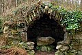 Stone Shelter within Donard Forest
 -
 Donard Forest as seen from Newcastle Promenade


References
- ^ a b "Donard Forest". NI Direct. Retrieved 17 December 2014.
- ^ Carson, Charles J. T. (2009). Technology and the Big House in Ireland, C. 1800-c. 1930. Cambria Press. pp. 123–124. ISBN 9781604976359.
- v
- t
- e
Forests and woodlands of Northern Ireland
- Ballyboley Forest
- Ballycastle Forest
- Ballypatrick Forest
- Bann Woods North Forest
- Bann Woods South Forest
- Breen Forest
- Capanagh Forest
- Carnfunnock Country Park
- Clare Forest
- Cleggan Forest
- Craigs Forest
- Garry Forest
- Glenariff Forest Park
- Glenarm Forest
- Muckamore Forest
- Portglenone Forest
- Randalstown Forest
- Slieveanorra Forest
- Tardree Forest
- Woodburn Forest
 Northern Ireland portal

- Ballymoyer Forest
- Camlough Forest
- Carnagh Forest
- Cold Brae Forest
- Drumbanagher Forest
- Fathom Forest
- The Fews Forest
- Gosford Forest Park
- Loughall Forest
- Maghery Country Park
- Seagahan Forest
- Slieve Gullion Forest Park
- Annalong Forest
- Ballysallagh Forest
- Belvoir Park Forest
- Bohill Forest
- Castleward Forest
- Castlewellan Forest Park
- Clandeboye Forest
- Donard Forest
- Drumkeeragh Forest
- Hillsborough Forest
- Hollymount Forest
- Mount Stewart Forest
- Mourne Forest
- Narrow Water Forest
- Rostrevor Forest
- Tollymore Forest Park
- Ballintempo Forest
- Belmore Forest
- Big Dog Forest
- Carnmore Forest
- Carrigan Forest
- Castle Archdale Forest
- Castlecaldwell Forest
- Clabby Forest
- Conagher Forest
- Crocknagrally Forest
- Crom Estate
- Derryline and Nann Island Forest
- Doon Forest
- Ely Lodge Forest
- Florence Court Forest Park
- Garrison Forest
- Grogey Forest
- Jenkin Forest
- Kesh Forest
- Knocks Forest
- Lough Navar Forest
- Marlbank Forest
- Necarne Forest
- Pubble Forest
- Riversdale Forest
- Sillees Forest
- Spring Grove Forest
- Tully Forest
- Tullychurry Forest
- Aghadowey Forest
- Ballykelly Forest
- Banagher Forest
- Binevenagh Forest
- Cam Forest
- Derrynoid Forest
- Downhill Forest
- Garvagh Forest
- Glenshane Forest
- Gortnamoyagh Forest
- Grange Park Forest
- Iniscarn Forest
- Learmount Forest
- Loughermore Forest
- Loughermore East Forest
- Moyola Forest
- Muff Glen Forest
- Roe Valley Country Park
- Somerset Forest
- Springwell Forest
- Aghyaran Forest
- Altmore Forest
- Baronscourt Forest
- Bradkeel Forest
- Caledon Forest
- Carrickaholten Forest
- Carrickaholten Forest
- Cookstown Forest
- Creggan Forest
- Davagh Forest
- Drum Manor Forest Park
- Dunmoyle Forest
- Fardoss Forest
- Favour Royal
- Glenderg Forest
- Goles Forest
- Gortin Glen Forest Park
- Killens Forest
- Knockmany Forest
- Lack Forest
- Ligfordrum Forest
- Lough Bradan Forest
- Moneygal Forest
- Moydamlaght Forest
- Mullaghfad Forest
- Parkanaur Forest Park
- Pigeon Top Forest
- Pomeroy Forest
- Seskinore Forest
- Slievedoo Forest
- Trillick Forest
 | This article related to the geography of County Down, Northern Ireland is a stub. You can help Wikipedia by expanding it. |
- v
- t
- e


