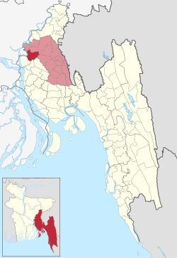
Daudkandi Upazila
Upazila in Chittagong, Bangladesh
Daudkandi দাউদকান্দি | |
|---|---|
Upazila | |
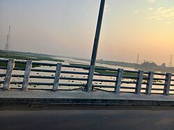 Daudkandi Bridge | |
 | |
| Coordinates: 23°32′N 90°43′E / 23.533°N 90.717°E / 23.533; 90.717 | |
| Country |  Bangladesh Bangladesh |
| Division | Chittagong |
| District | Comilla |
| Area | |
| • Total | 314.99 km2 (121.62 sq mi) |
| Population (2011) | |
| • Total | 349,910 |
| • Density | 1,100/km2 (2,900/sq mi) |
| Time zone | UTC+6 (BST) |
| Website | Official Map of Daudkandi |
Daudkandi (Bengali: দাউদকান্দি) is an upazila of Comilla District in the Division of Chittagong, Bangladesh.[1]
Geography
Daudkandi is located at 23°32′00″N 90°43′00″E / 23.5333°N 90.7167°E / 23.5333; 90.7167. It has 69,014 households and a total area of 314.99 km2 which is located at the extreme near of the upazila by the Dhaka Chittagong Highway. Daudkandi village area is within the municipality and value of property here, like the rest of the municipality, have increased significantly.
Demographics
| Religions in Daudkandi upazila (2011)[2] | ||||
|---|---|---|---|---|
| Religion | Percent | |||
| Islam | 93.44% | |||
| Hinduism | 6.54% | |||
| Other or not stated | 0.02% | |||
According to the 2011 Bangladesh census, Daudkandi Upazila had 69,014 households and a population of 349,910. 86,821 (24.81%) were under 10 years of age. Daudkandi has a literacy rate (age 7 and over) of 50.69%, compared to the national average of 51.8%, and a sex ratio of 1069 females per 1000 males. 46,256 (13.22%) lived in urban areas.[3][2]
Administration
Daudkandi Upazila is divided into Daudkandi Municipality and 16 union parishads: Baropara, Betessor, Dakshin Eliotgonj, Doulotpur, Goalmari, Gouripur, Maruka, Mohammadpur Paschim, Maligaon, Mohammadpur Purbo, Passgacia Pachim, Podua, Sundolpur, Uttar Daudkandi, Uttar Eliotgonj, and Zinglatoli. The union parishads are subdivided into 186 mauzas and 267 villages.[2]
Daudkandi Municipality is subdivided into 9 wards and 26 mahallas.[2]
| Position | Name |
|---|---|
| Upazila Chairman | Major (Retd.) Mohammad Ali |
| Vice Chairman | Tarikul Islam Noyon |
| Woman Vice Chairman | Rujina Akther |
| Upazila Nirbahi Officer (UNO) |
Notable residents
- Khondaker Mostaq Ahmad, 5th President of Bangladesh (15 August 1975 to 3 November 1975), was born at Dashpara village in 1919.[4]
- Major General (Retd.) Mohammad Shubid Ali Bhuiyan has been the Member Parliament for constituency Comilla-1 since 2009.[5][6]
- Dr. Khandaker Mosharraf Hossain, Minister of Health and Family Welfare (2001-2006)[7] and the Member of Parliament for constituency Comilla-2 from 1991 until 2006,[8] was born at Gayaspur village in 1946.[9]
- M Osman Ali, founding member of the Awami Muslim League
- Ashraf Chowdhury, Pakistan national football team, East Pakistan football team and Dhaka Mohammedan player.[10][11]
See also
References
- ^ Uddin, AKM Jasim (2012). "Daudkandi Upazila". In Islam, Sirajul; Jamal, Ahmed A. (eds.). Banglapedia: National Encyclopedia of Bangladesh (Second ed.). Asiatic Society of Bangladesh.
- ^ a b c d "Bangladesh Population and Housing Census 2011 Zila Report – Comilla" (PDF). bbs.gov.bd. Bangladesh Bureau of Statistics.
- ^ "Community Tables: Comilla district" (PDF). bbs.gov.bd. 2011.
- ^ Khan, Saleh Athar (2012). "Ahmad, Khondakar Mostaq". In Islam, Sirajul; Jamal, Ahmed A. (eds.). Banglapedia: National Encyclopedia of Bangladesh (Second ed.). Asiatic Society of Bangladesh.
- ^ "List of 9th Parliament Members". Bangladesh Parliament. Archived from the original on 2023-07-31. Retrieved 2018-02-07.
- ^ "Constituency 249_10th_En". Bangladesh Parliament.
- ^ "Ex-BNP minister Mosharraf indicted". The Daily Star. 29 October 2015.
- ^ "Parliament Election Result of 1991, 1996, 2001 Bangladesh Election Information and Statistics". Vote Monitor Networks. Archived from the original on 29 December 2008. Retrieved 4 February 2018.
- ^ "BNP leader Mosharraf's birthday today". Daily Sun. 1 October 2017.
- ^ "মরহুম আশরাফ চৌধুরী স্মরণে প্রীতি ফুটবলে আর্জেন্টিনার জয়". Daily Sangram (in Bengali). 30 January 2023. Archived from the original on 20 June 2024.
- ^ "::Sport::15th Anniversary Special". archive.thedailystar.net. Archived from the original on 11 February 2023. Retrieved 13 February 2023.
- v
- t
- e
Capital: Comilla

- Adra
- Aganagar
- Bakshaganj
- Balorampur
- Bangodda
- Baorkhola
- Bhabanipur
- Bhazon Kara
- Bhutua
- Chowara
- Daulkhar
- Dhalua
- Dulalpur
- Fultali
- Galimpur
- Gouripur
- Gunabati
- Haidarabad
- Jagatpur
- Jodda Union
- Kalakandi
- Kandirpar
- Karikandi
- Mainamati
- Majidpur
- Maniker Char
- Mokara
- Narayandia
- Nangalkot Municipality
- Paiyapathar
- Peria
- Roykot
- Satbaria
- Shahebabad
- Shilmuri North
- Shilmuri South
- Zearkandi
- Akhaura–Laksam–Chittagong line
- Comilla Airport
- Dakatia
- Gumti
- Railway stations
- Meghna
- N1
- Titas

 | This Chittagong Division location article is a stub. You can help Wikipedia by expanding it. |
- v
- t
- e


