Cossesseville
You can help expand this article with text translated from the corresponding article in French. (December 2008) Click [show] for important translation instructions.
- View a machine-translated version of the French article.
- Machine translation, like DeepL or Google Translate, is a useful starting point for translations, but translators must revise errors as necessary and confirm that the translation is accurate, rather than simply copy-pasting machine-translated text into the English Wikipedia.
- Do not translate text that appears unreliable or low-quality. If possible, verify the text with references provided in the foreign-language article.
- You must provide copyright attribution in the edit summary accompanying your translation by providing an interlanguage link to the source of your translation. A model attribution edit summary is
Content in this edit is translated from the existing French Wikipedia article at [[:fr:Cossesseville]]; see its history for attribution. - You may also add the template
{{Translated|fr|Cossesseville}}to the talk page. - For more guidance, see Wikipedia:Translation.
Commune in Normandy, France
Cossesseville | ||
|---|---|---|
Commune | ||
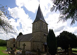 The church in Cossesseville | ||
Location of Cossesseville  | ||
(2020–2026) Laurence Serrurier[1] | | |
| Area 1 | 4.74 km2 (1.83 sq mi) | |
| Population (2021)[2] | 105 | |
| • Density | 22/km2 (57/sq mi) | |
| Time zone | UTC+01:00 (CET) | |
| • Summer (DST) | UTC+02:00 (CEST) | |
| INSEE/Postal code | 14183 /14690 | |
| Elevation | 38–201 m (125–659 ft) (avg. 150 m or 490 ft) | |
| 1 French Land Register data, which excludes lakes, ponds, glaciers > 1 km2 (0.386 sq mi or 247 acres) and river estuaries. | ||
Cossesseville (French pronunciation: [kɔsɛsvil]) is a commune in the Calvados department in the Normandy region in northwestern France.
Geography
The commune is part of the area known as Suisse Normande.[3]
The commune is made up of the following collection of villages and hamlets, La Sauvagère, Le Jardin, Le Fouc, Le Bout Dessous and Cossesseville.[4]
The River Orne plus two streams The Orival and Val la Here are the three watercourses that flow through the commune.
Neighbouring communes[4] | |
|---|---|


Population
| Year | Pop. | ±% |
|---|---|---|
| 1962 | 123 | — |
| 1968 | 125 | +1.6% |
| 1975 | 99 | −20.8% |
| 1982 | 83 | −16.2% |
| 1990 | 90 | +8.4% |
| 1999 | 88 | −2.2% |
| 2008 | 108 | +22.7% |
See also
References
- ^ "Répertoire national des élus: les maires". data.gouv.fr, Plateforme ouverte des données publiques françaises (in French). 2 December 2020.
- ^ "Populations légales 2021". The National Institute of Statistics and Economic Studies. 28 December 2023.
- ^ "Map of Suiss Normande" (PDF).
- ^ a b "Cossesseville · 14690, France". Cossesseville · 14690, France.
Wikimedia Commons has media related to Cossesseville.
- v
- t
- e
 Communes of the Calvados department
- Ablon
- Agy
- Amayé-sur-Orne
- Amayé-sur-Seulles
- Amfreville
- Angerville
- Anisy
- Annebault
- Arganchy
- Argences
- Arromanches-les-Bains
- Asnelles
- Asnières-en-Bessin
- Auberville
- Aubigny
- Audrieu
- Aure sur Mer
- Aurseulles
- Authie
- Les Authieux-sur-Calonne
- Auvillars
- Avenay
- Balleroy-sur-Drôme
- Banneville-la-Campagne
- Banville
- Barbery
- Barbeville
- Barneville-la-Bertran
- Baron-sur-Odon
- Barou-en-Auge
- Basly
- Basseneville
- Bavent
- Bayeuxsubpr
- Bazenville
- La Bazoque
- Beaufour-Druval
- Beaumais
- Beaumesnil
- Beaumont-en-Auge
- Bellengreville
- Belle Vie en Auge
- Benerville-sur-Mer
- Bénouville
- Bény-sur-Mer
- Bernesq
- Bernières-d'Ailly
- Bernières-sur-Mer
- Beuvillers
- Beuvron-en-Auge
- Biéville-Beuville
- Blainville-sur-Orne
- Blangy-le-Château
- Blay
- Blonville-sur-Mer
- Le Bô
- La Boissière
- Bonnebosq
- Bonnemaison
- Bonneville-la-Louvet
- Bonneville-sur-Touques
- Bonnœil
- Bons-Tassilly
- Bougy
- Boulon
- Bourgeauville
- Bourguébus
- Branville
- Brémoy
- Bretteville-le-Rabet
- Bretteville-sur-Laize
- Bretteville-sur-Odon
- Le Breuil-en-Auge
- Le Breuil-en-Bessin
- Le Brévedent
- Bréville-les-Monts
- Bricqueville
- Brucourt
- Bucéels
- Le Bû-sur-Rouvres
- Cabourg
- Caenpref
- Cagny
- Cahagnes
- Cahagnolles
- La Caine
- Cairon
- La Cambe
- Cambes-en-Plaine
- Cambremer
- Campagnolles
- Campigny
- Canapville
- Canchy
- Canteloup
- Carcagny
- Cardonville
- Carpiquet
- Cartigny-l'Épinay
- Le Castelet
- Castillon
- Castillon-en-Auge
- Castine-en-Plaine
- Caumont-sur-Aure
- Cauvicourt
- Cauville
- Cernay
- Cesny-aux-Vignes
- Cesny-les-Sources
- Chouain
- Cintheaux
- Clarbec
- Clécy
- Cléville
- Colleville-Montgomery
- Colleville-sur-Mer
- Colombelles
- Colombières
- Colombiers-sur-Seulles
- Colomby-Anguerny
- Combray
- Commes
- Condé-en-Normandie
- Condé-sur-Ifs
- Condé-sur-Seulles
- Coquainvilliers
- Cordebugle
- Cordey
- Cormelles-le-Royal
- Cormolain
- Cossesseville
- Cottun
- Courcy
- Courseulles-sur-Mer
- Courtonne-la-Meurdrac
- Courtonne-les-Deux-Églises
- Courvaudon
- Crépon
- Cresserons
- Cresseveuille
- Creully sur Seulles
- Cricquebœuf
- Cricqueville-en-Auge
- Cricqueville-en-Bessin
- Cristot
- Crocy
- Croisilles
- Crouay
- Culey-le-Patry
- Cussy
- Cuverville
- Damblainville
- Danestal
- Deauville
- Démouville
- Le Détroit
- Deux-Jumeaux
- Dialan sur Chaîne
- Dives-sur-Mer
- Donnay
- Douville-en-Auge
- Douvres-la-Délivrande
- Dozulé
- Drubec
- Ducy-Sainte-Marguerite
- Ellon
- Émiéville
- Englesqueville-en-Auge
- Englesqueville-la-Percée
- Épaney
- Épinay-sur-Odon
- Épron
- Équemauville
- Eraines
- Ernes
- Escoville
- Espins
- Esquay-Notre-Dame
- Esquay-sur-Seulles
- Esson
- Estrées-la-Campagne
- Éterville
- Étréham
- Évrecy
- Falaise
- Fauguernon
- Le Faulq
- Feuguerolles-Bully
- Fierville-les-Parcs
- Firfol
- Fleury-sur-Orne
- La Folie
- La Folletière-Abenon
- Fontaine-Étoupefour
- Fontaine-Henry
- Fontaine-le-Pin
- Fontenay-le-Marmion
- Fontenay-le-Pesnel
- Formentin
- Formigny La Bataille
- Foulognes
- Fourches
- Fourneaux-le-Val
- Le Fournet
- Fourneville
- Frénouville
- Le Fresne-Camilly
- Fresné-la-Mère
- Fresney-le-Puceux
- Fresney-le-Vieux
- Fumichon
- Gavrus
- Géfosse-Fontenay
- Genneville
- Gerrots
- Giberville
- Glanville
- Glos
- Gonneville-en-Auge
- Gonneville-sur-Honfleur
- Gonneville-sur-Mer
- Goustranville
- Gouvix
- Grainville-Langannerie
- Grainville-sur-Odon
- Grandcamp-Maisy
- Grangues
- Graye-sur-Mer
- Grentheville
- Grimbosq
- Guéron
- Hermanville-sur-Mer
- Hermival-les-Vaux
- Hérouville-Saint-Clair
- Hérouvillette
- Heuland
- La Hoguette
- Honfleur
- L'Hôtellerie
- Hotot-en-Auge
- Hottot-les-Bagues
- La Houblonnière
- Houlgate
- Ifs
- Isigny-sur-Mer
- Les Isles-Bardel
- Janville
- Jort
- Juaye-Mondaye
- Juvigny-sur-Seulles
- Laize-Clinchamps
- Landelles-et-Coupigny
- Landes-sur-Ajon
- Langrune-sur-Mer
- Léaupartie
- Leffard
- Lessard-et-le-Chêne
- Lingèvres
- Lion-sur-Mer
- Lisieuxsubpr
- Lison
- Lisores
- Litteau
- Livarot-Pays-d'Auge
- Les Loges
- Les Loges-Saulces
- Longues-sur-Mer
- Longueville
- Longvillers
- Loucelles
- Louvagny
- Louvigny
- Luc-sur-Mer
- Magny-en-Bessin
- Maisoncelles-Pelvey
- Maisoncelles-sur-Ajon
- Maisons
- Maizet
- Maizières
- Malherbe-sur-Ajon
- Maltot
- Mandeville-en-Bessin
- Manerbe
- Manneville-la-Pipard
- Le Manoir
- Manvieux
- Le Marais-la-Chapelle
- Marolles
- Martainville
- Martigny-sur-l'Ante
- Mathieu
- May-sur-Orne
- Merville-Franceville-Plage
- Méry-Bissières-en-Auge
- Meslay
- Le Mesnil-au-Grain
- Le Mesnil-Eudes
- Le Mesnil-Guillaume
- Le Mesnil-Robert
- Le Mesnil-Simon
- Le Mesnil-sur-Blangy
- Le Mesnil-Villement
- Meuvaines
- Mézidon Vallée d'Auge
- Le Molay-Littry
- Les Monceaux
- Monceaux-en-Bessin
- Mondeville
- Mondrainville
- Monfréville
- Montfiquet
- Montigny
- Montillières-sur-Orne
- Montreuil-en-Auge
- Monts-en-Bessin
- Les Monts d'Aunay
- Morteaux-Coulibœuf
- Mosles
- Mouen
- Moulines
- Moulins en Bessin
- Moult-Chicheboville
- Les Moutiers-en-Auge
- Les Moutiers-en-Cinglais
- Moyaux
- Mutrécy
- Nonant
- Norolles
- Noron-l'Abbaye
- Noron-la-Poterie
- Norrey-en-Auge
- Notre-Dame-de-Livaye
- Notre-Dame-d'Estrées-Corbon
- Noues de Sienne
- Olendon
- Orbec
- Osmanville
- Ouézy
- Ouffières
- Ouilly-du-Houley
- Ouilly-le-Tesson
- Ouilly-le-Vicomte
- Ouistreham
- Parfouru-sur-Odon
- Pennedepie
- Périers-en-Auge
- Périers-sur-le-Dan
- Périgny
- Perrières
- Pertheville-Ners
- Petiville
- Pierrefitte-en-Auge
- Pierrefitte-en-Cinglais
- Pierrepont
- Le Pin
- Planquery
- Plumetot
- La Pommeraye
- Pont-Bellanger
- Pont-d'Ouilly
- Pontécoulant
- Pont-Farcy
- Pont-l'Évêque
- Port-en-Bessin-Huppain
- Ponts sur Seulles
- Potigny
- Préaux-Bocage
- Le Pré-d'Auge
- Prêtreville
- Putot-en-Auge
- Quetteville
- Ranchy
- Ranville
- Rapilly
- Repentigny
- Reux
- Reviers
- La Rivière-Saint-Sauveur
- La Roque-Baignard
- Rocques
- Rosel
- Rots
- Rouvres
- Rubercy
- Rumesnil
- Ryes
- Saint-André-d'Hébertot
- Saint-André-sur-Orne
- Saint-Arnoult
- Saint-Aubin-d'Arquenay
- Saint-Aubin-des-Bois
- Saint-Aubin-sur-Mer
- Saint-Benoît-d'Hébertot
- Saint-Côme-de-Fresné
- Saint-Contest
- Saint-Denis-de-Mailloc
- Saint-Denis-de-Méré
- Saint-Désir
- Sainte-Croix-sur-Mer
- Sainte-Honorine-de-Ducy
- Sainte-Honorine-du-Fay
- Sainte-Marguerite-d'Elle
- Sainte-Marie-Outre-l'Eau
- Saint-Étienne-la-Thillaye
- Saint-Gatien-des-Bois
- Saint-Germain-de-Livet
- Saint-Germain-du-Pert
- Saint-Germain-la-Blanche-Herbe
- Saint-Germain-Langot
- Saint-Germain-le-Vasson
- Saint-Hymer
- Saint-Jean-de-Livet
- Saint-Jouin
- Saint-Julien-sur-Calonne
- Saint-Lambert
- Saint-Laurent-de-Condel
- Saint-Laurent-sur-Mer
- Saint-Léger-Dubosq
- Saint-Louet-sur-Seulles
- Saint-Loup-Hors
- Saint-Manvieu-Norrey
- Saint-Marcouf
- Saint-Martin-aux-Chartrains
- Saint-Martin-de-Bienfaite-la-Cressonnière
- Saint-Martin-de-Blagny
- Saint-Martin-de-Fontenay
- Saint-Martin-de-la-Lieue
- Saint-Martin-de-Mailloc
- Saint-Martin-de-Mieux
- Saint-Martin-des-Entrées
- Saint-Omer
- Saint-Ouen-du-Mesnil-Oger
- Saint-Ouen-le-Pin
- Saint-Pair
- Saint-Paul-du-Vernay
- Saint-Philbert-des-Champs
- Saint-Pierre-Azif
- Saint-Pierre-Canivet
- Saint-Pierre-des-Ifs
- Saint-Pierre-du-Bû
- Saint-Pierre-du-Fresne
- Saint-Pierre-du-Jonquet
- Saint-Pierre-du-Mont
- Saint-Pierre-en-Auge
- Saint-Rémy
- Saint-Samson
- Saint-Sylvain
- Saint-Vaast-en-Auge
- Saint-Vaast-sur-Seulles
- Saint-Vigor-le-Grand
- Sallen
- Sallenelles
- Sannerville
- Saon
- Saonnet
- Sassy
- Seulline
- Soignolles
- Soliers
- Sommervieu
- Soulangy
- Souleuvre en Bocage
- Soumont-Saint-Quentin
- Subles
- Sully
- Surrain
- Surville
- Terres de Druance
- Tessel
- Thaon
- Le Theil-en-Auge
- Thue et Mue
- Thury-Harcourt-le-Hom
- Tilly-sur-Seulles
- Le Torquesne
- Touffréville
- Touques
- Tour-en-Bessin
- Tourgéville
- Tournières
- Tourville-en-Auge
- Tourville-sur-Odon
- Tracy-Bocage
- Tracy-sur-Mer
- Tréprel
- Trévières
- Troarn
- Le Tronquay
- Trouville-sur-Mer
- Trungy
- Urville
- Ussy
- Vacognes-Neuilly
- Valambray
- Valdallière
- Val d'Arry
- Val de Drôme
- Val-de-Vie
- Valorbiquet
- Valsemé
- Varaville
- Vaucelles
- Vauville
- Vaux-sur-Aure
- Vaux-sur-Seulles
- Vendes
- Vendeuvre
- Versainville
- Verson
- Ver-sur-Mer
- La Vespière-Friardel
- Le Vey
- Vicques
- Victot-Pontfol
- Vienne-en-Bessin
- Vierville-sur-Mer
- Vieux
- Vieux-Bourg
- Vignats
- Villers-Bocage
- Villers-Canivet
- Villers-sur-Mer
- Villerville
- La Villette
- Villons-les-Buissons
- Villy-Bocage
- Villy-lez-Falaise
- Vimont
- Vire Normandiesubpr
- pref: prefecture
- subpr: subprefecture
| Authority control databases: National |
|
|---|
 | This Calvados geographical article is a stub. You can help Wikipedia by expanding it. |
- v
- t
- e


